The Shephelah
There were four main passages from the Trunk Road through valleys of the Shephelah and up Judah's mountain . Cities sat on these passages according to a pattern: (1) there was a city on the coastal Trunk Road where it meets a broad valley leading east; (2) there was a city near this valley's eastern end, where an unbroken ridge or defile begins to ascend the mountain; and (3) there was a city on top. We devote a separate article to this pattern.
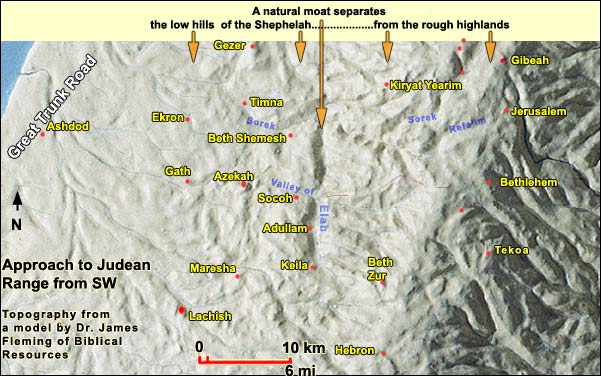
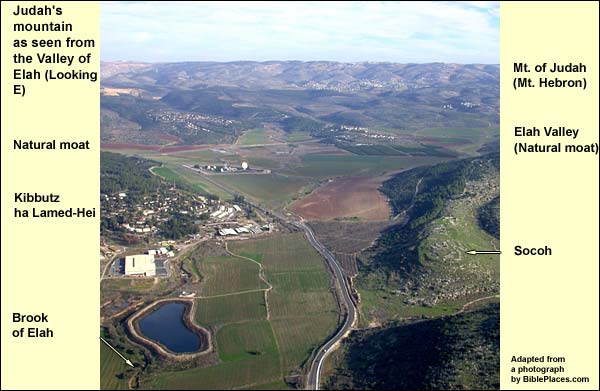
In time of war, geography protected the Judean range. First, there is a natural moat, formed by north-south valleys that separate the Shephelah from the mountain. (The Valley of Elah, where Goliath met his match, was one of these.) Second, the western flank of the mountain is extremely steep and rugged, while the few passages are narrow. Unless an army chose the northernmost route, it could not march straight up from the west as long as an enemy occupied the high ground. When we stand in the Shephelah, therefore, we seem to be very close to Judah, but if we are an army, we are still very far.
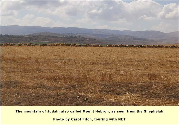
Not only is Judah's mountain protected on the west. It is protected on the east by the wilderness and on the south by the Negev desert. The heartland of Judah, in short, is a landed peninsula, easily accessible only from the plateau on its north side. (Jeremiah 1:14. "Out of the north evil will break out on all the inhabitants of the land.") The mountain is off the main international routes and difficult to farm because of its steepness. These factors dampened the interest of potential invaders. Consider, for instance, the Assyrians in 701 BC. They concentrated on Lachish and the Trunk Road to Egypt, sending only a detachment up from the west (apparently unopposed) to Jerusalem. If they had focused on Jerusalem, taking it and scattering its population as they'd done with the northern tribes, the Judeans there would have suffered the fate of the northerners: they would have lost their group identity. Who then would have been around to preserve the texts that became our Bible? (The Samaritans? Convention to the contrary, they did not yet exist). Today's world would be very different: no Bible, no Judaism, no Christianity, and no Islam.
After the Assyrians came the Babylonians. In the century between them, however, much of the First Testament was crystallized. The Babylonians did take Jerusalem and Judah, but unlike the Assyrians, they kept the exiles together. The exiled Judeans (and, starting in 538 BC, those among them who returned) were called yehudim in Hebrew, i.e. Jews. They preserved the Biblical texts. This hulk of a mountain, which protected Jerusalem from the Assyrians, has much to do with who we are.
{mospagebreak title=Shephelah Passes}
Passes through the Shephelah
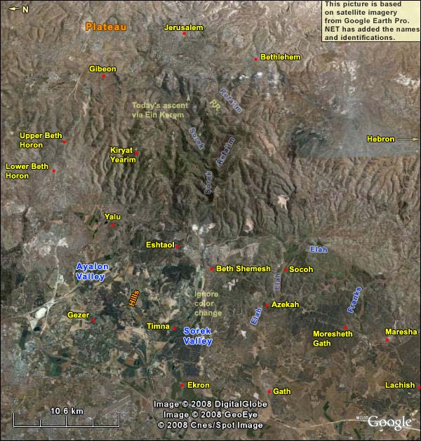
There were four main passages from the Trunk Road through valleys of the Shephelah and up Judah's mountain . Cities sat on these passages according to a pattern: (1) there was a city on the coastal Trunk Road where it meets a broad valley leading east; (2) there was a city near this valley's eastern end, where an unbroken ridge or defile begins to ascend the mountain; and (3) there was a city on top. You can find these four passages on the satellite photo below by taking the valleys as your guide: from N to S, Ayalon, Sorek, Elah and the Valley of the Franks. The middle cities on the four passages were joined by a diagonal route from NE to SW. It linked Yalu (or later the nearby Emmaus), Eshtaol, Beth Shemesh, Azekah, Moresheth Gath and Maresha.
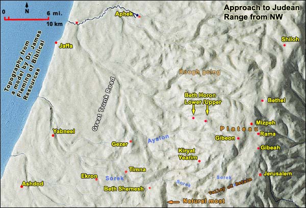
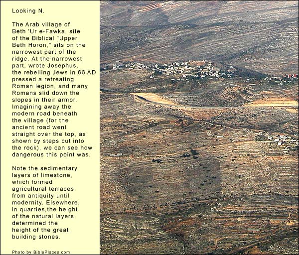
We shall now study the passages one at a time. 1.The Beth Horon ridge The northernmost passage in this system was the most famous. The city at the intersection with the Trunk Road was called Intersection, or in Hebrew: Gezer. (The traffic reached Gezer from Jaffa; in the time of the 2nd Testament, when Gezer's importance declined, Antipatris and Lydda took over its function.) Gezer guarded the entrance to the Valley of Ayalon, at whose eastern edge was the city of Yalu that gave that valley its name. (The strategic role of Yalu was later assumed by nearby Emmaus, to which we devote a separate article.) From here began the ascent of the Beth Horon ridge, which – uniquely for the area – remained unbroken up to Gibeon on the Benjamin Plateau. The latter gave access in all directions, including south to Jerusalem and east to the King's Highway .
George Adam SmithGeorge Adam Smith, The Historical Geography of the Holy Land, Jerusalem, Ariel, 1974 (30th edition) (pp. 149-154) lists the many battles that occurred up and down this passage. To name just a few:
a. On the day when the sun stood still, Joshua broke the Canaanite siege of Gibeon, his new ally, and drove the enemy down to the Shephelah: It happened, as they fled from before Israel, while they were at the descent of Beth Horon, that Yahweh cast down great stones from the sky on them as far as Azekah, and they died. There were more who died from the hailstones than those whom the children of Israel killed with the sword (Joshua 10:11).
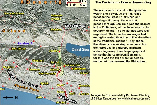
b. Although the Philistines were settled on the southern coast, the Beth Horon route was probably crucial 1 Samuel 13:16 -18. The Philistines encamped in Michmash on the east end of the plateau. Detachments came out of the camp of the Philistines in three companies: one company turned to the way that leads to Ophrah, to the land of Shual; and another company turned the way to Beth Horon; and another turned the way of the border that looks down on the valley of Zeboim toward the wilderness. in their campaign to dominate the land (not be dominated). At its top, on the plateau, was the tribe of Benjamin. The Philistines were better organized and faster than any enemy yet encountered by the Israelites. These felt they would need a standing army to meet the new threat, and that would mean having a human king. Because the tribe of Benjamin sat on the Beth Horon road, it is geographically logical that the king would come from it. His name was Saul. He and his son Jonathan drove out the Philistines, "from Michmash [off the east edge of the plateau] to Ayalon" (1 Samuel 13: 41).
d. After defeating Saul in the north, the Philistines again attempted to occupy Judah, and this time it was David who drove them down, "from Gibeon to Gezer" (2 Samuel 5: 25).
e. Up and down this route swept many of the battles between the Greeks and the Maccabees .
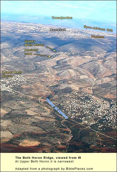
f. Roughly a millennium after David, in 66 AD, tensions between Jews and Gentiles in Caesarea Maritima reached a boiling point, and the Gentiles there massacred the Jews. Throughout the country, Jews turned on Gentiles in reprisal. Thousands died on both sides. The Roman legate in Syria, Cestius Gallus, realized he had a problem. He came with a legion at summer's end and laid siege to Jerusalem. But then, for reasons that JosephusJosephus Flavius (36 – 100 AD), Jewish general, one of two directing the revolt against Rome in Galilee. After Vespasian captured him, he prophesied the latter would be emperor. When this proved true, the Romans honored him. He then turned historian, writing The Jewish War, The Antiquities of the Jews and many other books. Because of a paragraph about John the Baptist (and maybe a sentence about Jesus), the Church preserved his works. could not fathom (and which we, therefore, don't know) he "recalled his soldiers from the place, and by despairing of any expectation of taking it, without having received any disgrace, he retired from the city, without any reason in the world" (War,Josephus Flavius, The Wars of the Jews, translated by William Whiston (II 8.7). This encouraged the Jews, who pressed his troops at the narrow place on the ridge of Beth Horon, so that the Romans lost their footing and rolled down the slopes into the ravines. Added to smaller triumphs at Masada and Jerusalem, this victory encouraged the Jews to make a full-fledged rebellion. Many who'd been sitting on the fence joined in. The first great revolt against Rome was on.
g. Again to jump a millennium: the Crusaders in 1098 came up through Ayalon and the Beth Horon ridge to take Jerusalem. After losing the Holy City, they tried again in 1192 under Richard the Lion-Hearted: "It is remarkable that when Richard decided to besiege Jerusalem, and had marched from Ashkelon to Blanchegarde [ancient Gath], instead of pursuing …[the Valley of Elah] and its narrow continuation to Bethlehem, he preferred to turn north two days' march across the Shephelah hills with his flank to the enemy, and attack his goal up the Valley of Aijalon" (George Adam SmithGeorge Adam Smith, The Historical Geography of the Holy Land, Jerusalem, Ariel, 1974 (30th edition) (p. 161). The attack failed.
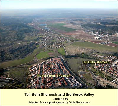
2. The Sorek Valley We head south. The next east-west passage in the pattern begins at Philistine Ekron, at the point of intersection with the coastal Trunk Road, and extends through the Valley of Sorek. The intermediate city was Beth Shemesh, east of which the Sorek winds as a narrow defile up the mountain (see the satellite photo above). When George Adam Smith wrote his great work at the end of the 19th century, the Sorek was the main road to Jerusalem. It contained the railway from Jaffa to the Holy City, as it still does today. The railway branches south into the Valley of Refa'im, where the Philistines once assembled.2 Samuel 5:17-18. When the Philistines heard that they had anointed David king over Israel, all the Philistines went up to seek David; and David heard of it, and went down to the stronghold. Now the Philistines had come and spread themselves in the valley of Rephaim.
Enlarge the picture on the right for a closer view of the Sorek defile.
Beth Shemesh means "Place of the Sun." We ascend the slight rise of the tellIn general, before the Roman period, a city needed a hill for defense, with a spring nearby. Certain proportions had to be right: the hill had to be small enough so that the population supplied by the spring would suffice to produce enough soldiers to defend a wall surrounding the hill. You needed enough good agricultural land to feed that population. (You also needed peasants in nearby villages to work the land – about ten for every aristocrat in the city.) If you wanted to engage in commerce, you had to be near a decent road. Only certain hills fulfilled these requirements, and therefore people kept building on them. That is why we find layer after layer on some few hills, called tells, while others remained unsettled. and look through the valley toward the coast. This is Samson country. (His name, Shimshon in Hebrew, derives from shemesh, "sun.) In the Sorek Valley, between Beth Shemesh and Philistine Ekron, lay the town of Timna, where Samson took a Philistine wife and killed a lion. The valley gave easy access to the land of the Philistines, and the Samson stories are largely concerned with his acts of vengeance against this people. Looking westward down its length in summer before the wheat harvest, one can imagine the devastating effect that 150 pairs of burning foxes would have on fields of grain.Judges 15: 4-5. Samson went and caught three hundred foxes, and took torches, and turned tail to tail, and put a torch in the midst between every two tails. When he had set the brands on fire, he let them go into the standing grain of the Philistines, and burnt up both the shocks and the standing grain, and also the olive groves. (And what about the foxes?!)
Samson was from the tribe of Dan. "The Amorites," we are told in Judges 1:34, "forced the children of Dan into the hill country; for they would not allow them to come down to the valley." This implies that Dan was supposed to inhabit the coastal plain but was pressed east into the Shephelah. Perhaps it did have the coast at one time, for the Song of Deborah (Judges 5:17) asks why Dan remained "in ships" instead of answering her call to battle. Judges 18 reports that the Danites weren't able to hold the land allotted them. They sent spies from Zora and Eshtaol, which are near Beth Shemesh, and later migrated to the far north. Here they conquered a city called Laish, renaming it Dan. The sequence of stories presented in Judges puts this migration after the Samson saga.
When we stand on the tell of Beth Shemesh looking west, another story comes to mind as well. The Philistines had captured the ark of the covenant (1 Samuel 4), but wherever they brought it, they had trouble: first in Ashdod, then in Gath. Finally, they sent it to Ekron. It happened, as the ark of God came to Ekron, that the Ekronites cried out, saying, 'They have brought the ark of the God of Israel to us, to kill us and our people.' They sent therefore and gathered together all the lords of the Philistines, and they said, 'Send away the ark of the God of Israel, and let it go again to its own place, that it not kill us and our people' (1 Samuel 5: 10-11).
The Philistines did not send the ark back, however, without first putting the matter to a test. They took two cows that had recently calved, tied them to a cart, and on the cart they loaded the ark, together with golden symbols of the troubles they had endured. As for the calves, they put them in a barn. They thought, if the cows do the natural thing and move toward their calves in the barn, then our troubles are not from Yahweh. However, if the cows do the unnatural thing and move away from their calves and toward the land of the Israelites, then we know that our troubles were indeed from Yahweh.
The men did so, and took two milk cows, and tied them to the cart, and shut up their calves at home; and they put the ark of Yahweh on the cart, and the coffer with the mice of gold and the images of their tumors. The cows took the straight way by the way to Beth Shemesh; they went along the highway, lowing as they went, and didn’t turn aside to the right hand or to the left; and the lords of the Philistines went after them to the border of Beth Shemesh.
They of Beth Shemesh were reaping their wheat harvest in the valley; and they lifted up their eyes, and saw the ark, and rejoiced to see it. The cart came into the field of Joshua of Beth Shemesh, and stood there, where there was a great stone: and they split the wood of the cart, and offered up the cows for a burnt offering to Yahweh. The Levites took down the ark of Yahweh, and the coffer that was with it, in which the jewels of gold were, and put them on the great stone: and the men of Beth Shemesh offered burnt offerings and sacrificed sacrifices the same day to Yahweh. When the five lords of the Philistines had seen it, they returned to Ekron the same day. (1 Samuel 6: 10-16)
After gazing too long at the ark, however, many people of Beth Shemesh were struck dead. Sensible of the danger attending so holy a thing, the Beth Shemeshites preferred not to have it. They called the highland (Gibeonite!) town of Kiryath Yearim to take it from them. This was also a safer place, up and away from the vulnerable Shephelah.
Before leaving the Sorek Valley, we should note that there was a huge city less than three miles south of Beth Shemesh in the third millennium BC, the Early Bronze Age. Occupying 14.5 hectares (36 acres), it seems similar in layout to EB Arad. Although much smaller in the Iron Age, when it was called Yarmuth, it was still powerful enough to be among the five allies Joshua 10:5. Therefore the five kings of the Amorites, the king of Jerusalem, the king of Hebron, the king of Yarmuth, the king of Lachish, the king of Eglon, gathered themselves together, and went up, they and all their armies, and encamped against Gibeon, and made war against it. that Joshua defeated on the day the sun stood still.
3. The Valley of Elah
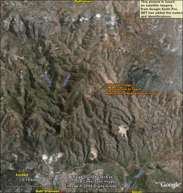
Moving south, we come to the third east-west passage through the Shephelah. Here the intersection with the plain was at Philistine Gath. The valley is that of Elah ("pistachio tree"). Where it twists and narrows there were two intermediary cities, Azekah and Socoh. Just east of the latter, the valley curves south, becoming part of the natural moat that separates the Shephelah from the Judean range. If we head due east, not following the curve, we find a ridge leading up to Bethlehem. This is the ridge that Richard the Lion-Hearted thought too narrow, preferring to march by way of Beth Horon.
According to 1 Samuel 17, the Valley of Elah was the setting for the contest between David and Goliath. We shall treat it in a separate article.
You can use the satellite photo above to see the passage from Gath to Bethlehem. Below is part of it closer up. Note that only one ridge is unbroken here. This was the route that the Philistines would have wanted to take and that Saul would have been defending. It was the way that David probably took, bringing supplies to his brothers in the army.
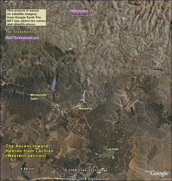
4. The Way to Hebron
We continue south to seek the fourth east-west passage through the Shephelah. (George Adam Smith counted five, but the division seems artificial.) We don't find a single broad valley, rather several possibilities. On the coast were Ashkelon and, south of it, Gaza. If you came from Egypt and headed east across the coastal plain, you would encounter a city where Tell el-Hesi is today. This may have been Eglon, which, during one of its phases at least, was powerful enough to join the confederacy against Gibeon Joshua 10:5. Therefore the five kings of the Amorites, the king of Jerusalem, the king of Hebron, the king of Yarmuth, the king of Lachish, the king of Eglon, gathered themselves together, and went up, they and all their armies, and encamped against Gibeon, and made war against it..
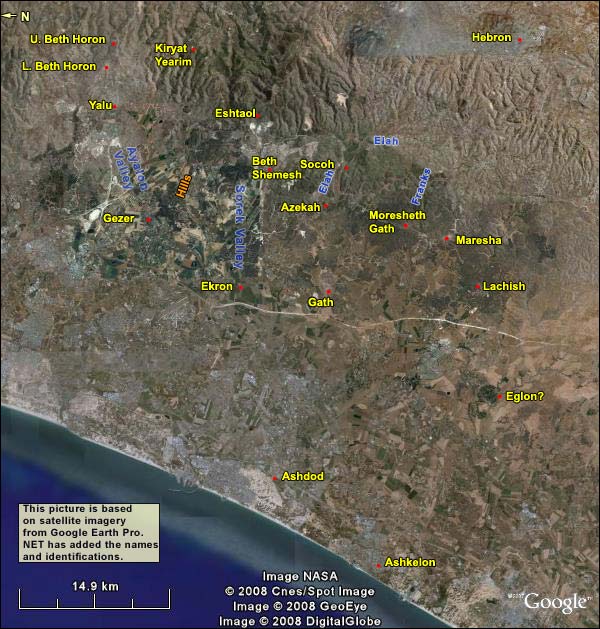
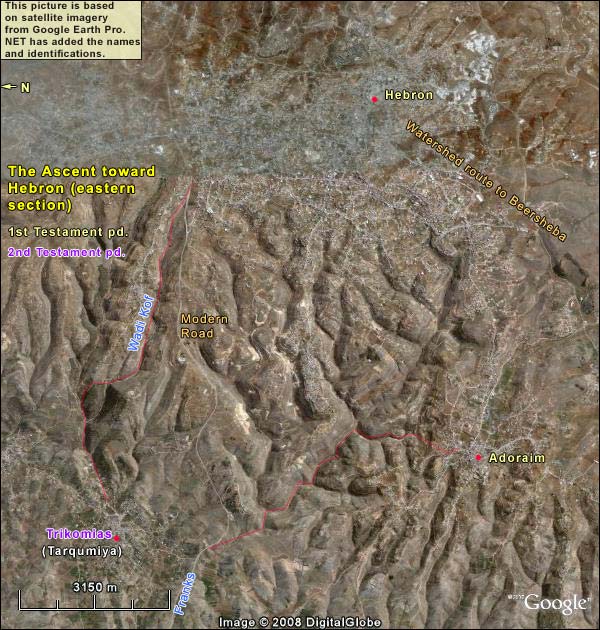
But the city at Tell el-Hesi, whatever its Biblical identity, was vulnerable compared to Lachish, which we'll discuss separately. Lachish dominated a valley leading to an intermediate city and thence up the mountain to Hebron. The intermediate city varied with the ages, shifting within a small radius. At one time it was Maresha, which was founded by Israelites as part of a defensive chain around the mountain of Judah. After Maresha's destruction in 40 BC, Beit Guvrin arose a kilometer away to dominate the route. We shall discuss Maresha/Beth Guvrin in a separate article.
That closes the list of east-west passages from the Great Trunk Road through the Shephelah to the mountain of Judah. Let us list them again from N to S, with their cities:
1. The Valley of Ayalon, from Gezer to Yalu (later Emmaus), then up the Beth Horon Ridge to the Central Benjamin Plateau and Jerusalem.
2. The Sorek Valley, from Ekron to Beth Shemesh, then up the Sorek defile to Jerusalem.
3. The Valley of Elah, from Gath to Azekah and Socoh, then up a long narrow unbroken ridge to Bethlehem and Jerusalem.
4. Valleys from Lachish to Maresha (Beit Guvrin), then the Valley of the Franks, then up through the defile of Wadi Kof or via Adoraim to Hebron.