Ein Gedi
A short hike to a waterfall and back
Most tour groups that visit Ein Gedi, including NET's, do so on a day that includes Masada, Qumran and a float in the Dead Sea. Our time here is limited, therefore, to about an hour and a half. This is enough for a leisurely hike along the David River (Nahal David). That is a very small portion, however, of all there is to see and do. Ideally, one would like two full days. Let us start with the usual hike, then move through links to more ambitious possibilities.
Soon after entering the nature reserve, we spot some caves across from us on the north side of the riverbed. Inside were found the remains of wooden coffins, decorated with inlays in the form of circles, rosettes and pomegranates They date from the early first century BC, when the HasmoneansThe Hasmoneans: family of Judah Maccabee ("the hammer") and his brothers, who revolted successfully against the Greek Empire in 167 BC. They purified and re-dedicated the Temple in Jerusalem, establishing the festival of Hanukah ("dedication"). They ruled till 63 BC, and their domain extended almost as far as King David's. ruled the land. (The access to them has since been eroded away.)
We would like to find an older and deeper cave:
It happened, when Saul was returned from following the Philistines, that it was told him, saying, “Behold, David is in the wilderness of En Gedi.”
cb(24,2); Then Saul took three thousand chosen men out of all Israel, and went to seek David and his men on the rocks of the wild goats.
cb(24,3); He came to the sheep pens by the way, where there was a cave; and Saul went in to relieve himself. Now David and his men were abiding in the innermost parts of the cave.
cb(24,4); ) More...
The closest we can come to a cave at Ein Gedi that is old enough and deep enough to fit this account is the Cave of the Cistern or Pool, which is much higher up in the canyon. This cave, however, is difficult to reach and would have been so, too, in David's day: a good hideout, but hardly a convenient WC. Limited in time and strength, we can tell the story opposite these later burial caves, using one of them as an aid to the imagination.
At the end of the account in 1 Samuel 24, we read that David went from Ein Gedi to "the stronghold" or fortress, which in Hebrew is ha-metzudah, perhaps a reference to the natural fortress, ten miles south of here, that later came to be called Masada.
And now we start our hike:
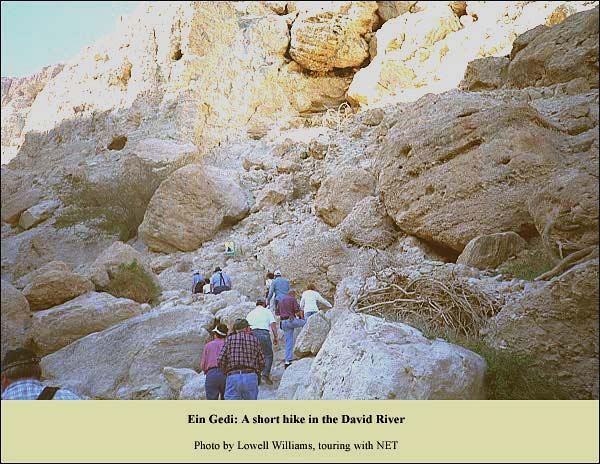
In the distance, at the last vegetation, we can just make out the pretty little waterfall toward which we are heading.
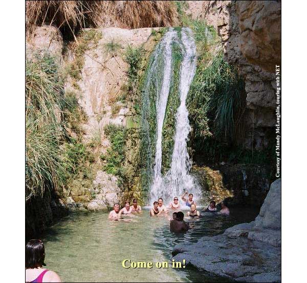
In the hot months, it is good to take a break at a water chute:
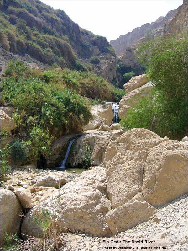
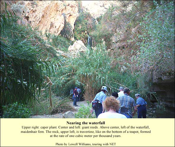
Refreshed, we continue through the lush vegetation toward a pretty little waterfall:
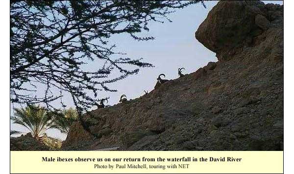
We then arrive at the waterfall. It is so pretty that no picture will do it justice (and so we refrain from posting one here). In winter, on the return, we may be observed by ibex:
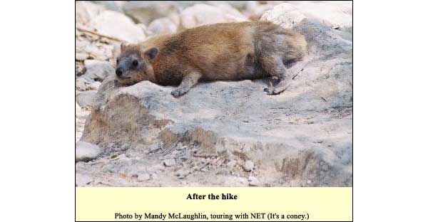
After wending our way back, it is time for a little break:
{mospagebreak title=The Bigger Picture}
Ein Gedi: The Bigger Picture
Ein Gedi includes TellIn general, before the Roman period, a city needed a hill for defense, with a spring nearby. Certain proportions had to be right: the hill had to be small enough so that the population supplied by the spring would suffice to produce enough soldiers to defend a wall surrounding the hill. You needed enough good agricultural land to feed that population. (You also needed peasants in nearby villages to work the land – about ten for every aristocrat in the city.) If you wanted to engage in commerce, you had to be near a decent road. Only certain hills fulfilled these requirements, and therefore people kept building on them. That is why we find layer after layer on some few hills, called tells, while others remained unsettled. Goren, whose oldest stratum dates from the late 7th century BC, the time of King Josiah (and the prophet Jeremiah). The finds from this level include pieces of vessels like those shown in Egyptian reliefs depicting the manufacture of perfume. The jars in the reliefs were used to collect liquid from pressed flowers. Other finds suggest commerce with Phoenicia, the great maritime trading empire of the day. We may infer, therefore, that already at the time of Ein Gedi's founding, its citizens were busy making the famous perfume called balsam, which the Phoenicians likely bought up and traded throughout the Mediterranean world.
In founding Ein Gedi, Josiah had not only commerce in mind, but defense as well. The Middle East was in turmoil during the last quarter of the 7th century BC. Under pressure of the Babylonians and the Medes, the Assyrian empire crumbled. Egypt, for its part, was preoccupied (at first) with internal problems, so that Josiah could take advantage of the vacuum to expand his realm. He encircled the Judean heartland with fortress cities, including Ein Gedi. Its specific task would have been to defend against potential Edomite attacks from the south and east. The Ein Gedi oasis was a likely target, because roads led from it across the small Judean desert to Hebron and Jerusalem. From the time of Josiah we find, therefore, not only the small city beside the oasis, but also a military lookout on the plateau high above:
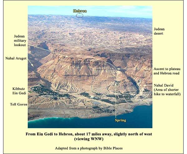
You can see the relationships by enlarging the map on the left. Note that Ein Gedi lies opposite the opening of the Arnon River on the eastern side of the Dead Sea. The gorge of the Arnon marked the northern border of Moab much of the time, as well as the southern border for Israelite settlement in Transjordan. The Dead Sea was not a barrier. We know that Ein Gedi had a harbor at the time of the Bar Kokhba revolt (its leader refers, in a letter, to a ship here), and there is no reason to rule out maritime traffic in earlier periods. We should think of Ein Gedi, then, as a point of contact between Judah and Transjordan.
Here is a view of the setting from the opposite angle, followed by a close-up of the same:
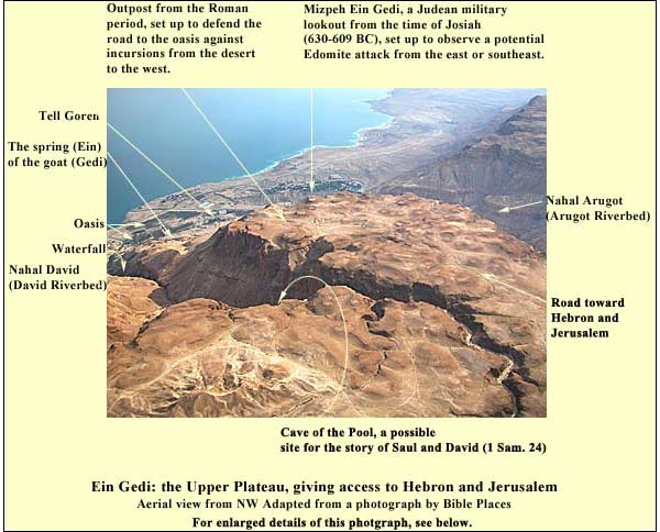
Note that the Judean lookout from Josiah's time was positioned to observe threats from the east and the south, while protecting the road from the oasis (below, left) to Hebron and the rest of Judah. In the Roman period, however, the threats did not come from the east or south. The need was rather to defend the balsam plantations against raids by tribes from the desert to the west. The military outpost was therefore placed away from the edge, beside the road. (Keel,Othmar Keel, Max Kuechler and Christoph Uehlinger, Orte und Landschaften der Bibel, Koeln: Benziger and Goettingen: Vandenhoeck and Ruprecht, 1984. Volumes I and II. p. 438.)
This is the road that David, escaping from the central highlands, would have taken with Saul on his heels. Across the chasm is a cave some 30 meters deep. It is the only cave at Ein Gedi deep enough to fit the Biblical account, although access to it is difficult. The cistern just inside its entrance has led archaeologists to call it the "Cave of the Pool." It was briefly inhabited in the Chalcolithic period, and again at the time when Josiah founded the small city below. Most of the finds, however, date from the time of the Bar Kokhba revolt. The rebels that hid from the Romans here did not share, apparently, the gruesome fate of their colleagues who used the caves in riverbeds a few miles to the south. At least there are no signs of Roman intrusion. (Source: (Keel,Othmar Keel, Max Kuechler and Christoph Uehlinger, Orte und Landschaften der Bibel, Koeln: Benziger and Goettingen: Vandenhoeck and Ruprecht, 1984. Volumes I and II. pp. 438-39.)
{mospagebreak title=Chalcolithic Temple}
Ein Gedi: A Hike to the Chalcolithic Temple
There are many possible hikes at Ein Gedi. For example, there is a one through the Arugot riverbed to a hidden waterfall. This is rather like the hike along the David River on a bigger scale. Above the David waterfall are the "sliding ponds" of the Dry Canyon, and, one level below it, the Cave of the Lovers (dodim). One can also hike up to the Judean military lookout on the upper plateau for a magnificent panorama. Or to the higher summit of Har Ishai just north of the David.
A starting point for many of these hikes is the ChalcolithicThe Chalcolithic (Copper-Stone) Age lasted from about 4000 until about 3100 BC. For the first time people were able to extract metal from ore. They managed to achieve temperatures of 1200 degrees centigrade in smelting ovens, which resulted in the separation of copper. Chalcolithic finds are numerous in this land – moreso than anywhere else in the world. temple on the first plateau above the David waterfall. It can be approached from the fall, but it is best to save the most beautiful part for the end: that is, to start from Tell Goren near the mouth of the Arugot River. On our way to the tell from the main road, we can make a brief departure to the ruins of an ancient synagogue. It belonged to the village that thrived here from the 3d century AD until the 6th. A lengthy mosaic inscription includes a curse against "anyone who reveals the secret of the city," perhaps the secret of balsam production. (For pictures of the finds from the synagogue, see this site and go to the bottom of the page.)
The plan of the hike: From Tell Goren we shall ascend by foot to the Ein Gedi Spring, then to the temple, and then (if we do not wish to hike further, or if we have only 2.5 hours) we shall descend via the Shulamit Spring to the waterfall, leaving the reserve by way of the David River.
From the tell we follow a jeep track northward, but soon after the start of its southward back-switch, we find a footpath leading north and up to the vegetation.
The spring of Ein Gedi forms a pool, around which we can sit and read the Song of Songs. It is a favorite hangout for coneys and ibex. A little to the north, on a higher rise, we find the remains of a Chalcolithic temple. Those who built it here, about 5000 years ago, chose a magnificent position:
This temple dates from the end of the period, around 3100 BC, and bears a close resemblance to one at Megiddo. It is something of a mystery on two counts. First, no trace of a Chalcolithic settlement has been found at Ein Gedi, nor indeed in the region. Second, the archaeologists saw no signs of destruction or plunder, but they found no ritual implements.
The solution to this riddle may have been found in a cave in the Mishmar Riverbed, five miles to the south. Here in 1961, archaeologists discovered, wrapped in a mat, 436 copper objects. The copper was mixed with arsenic (probably imported from northern Turkey), which made it easier to pour into molds (Mazar Amichai Mazar, Archaeology of the Land of the Bible: 10,000 - 586 B.C.E, New York: Doubleday, 1990. 74).
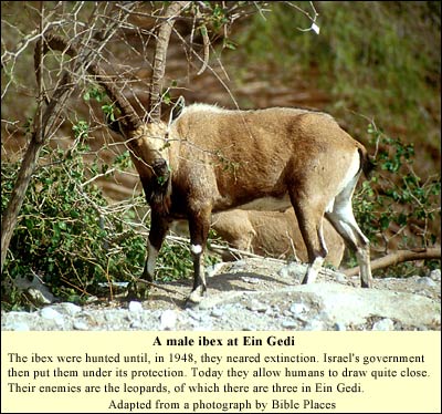
The implements, on view at the Israel Museum, include crowns, mace heads, vessels, hollow rods for use in procession, and ornamented weapons. The objects are sometimes decorated with representations of male ibex. These wild goats would have gathered at the oasis especially during the summer months, when there was less to eat and drink in the surrounding desert. We may imagine that people came here at this season to hunt, asking the deity housed in the temple to bring the ibex to them. They would fetch the ritual implements from the cave in the Mishmar Riverbed, do their dancing and hunting, return the implements and go back to wherever they had come from (the desert, perhaps, or their settlement in Beersheva, or their major center at Teleilat Ghassul in Transjordan east of Jericho).
The spring water gives rise to the oasis and hence, in a sense, to the ibex. This water was central, apparently, to the cult in the temple. In the middle of the courtyard we can see the remains of a ceremonial basin. One of the gates is directed toward the Shulamit spring, and beside it are the remains of a canal which apparently led to the basin. The other gate is directed toward the Ein Gedi spring.
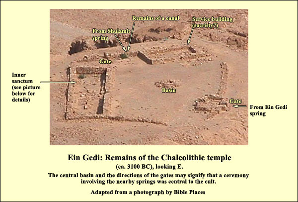
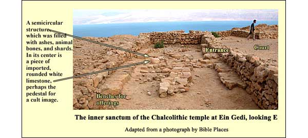
The main sanctuary is a broad room, about 20 meters long and 5 across. In the semicircular construction, the archaeologists found animal bones, pottery shards, and ashes, as well as a base of imported limestone. There were benches for offerings and more than 20 round pits, on either end, containing the ashes of these.
From the Chalcolithic temple one can find trails leading in several directions: to the Shulamit spring and down a flight of steps to the David waterfall and the exit; to the Cave of the Lovers (Dodim); to the Dry Canyon; and to the upper plateau with the Judean military lookout, affording a grand view. Be sure to leave enough time, for the Nature Reserve is strict about its closing hours.
{mospagebreak title=Logistics}
Ein Gedi: Logistics for a Visit
Telephone 08-658 4285
Ein Gedi is a Nature Reserve (no plucking, no eating except at designated sites).
Opening hours:
April-September: 8:00-17:00
October-March: 8:00-16:00
The reserve officials enforce these hours strictly in deference to the needs of the animals, which come down to drink. In winter, if you want to do the short hike to the waterfall in the David River and back, you should arrive no later than 14:30. If you want to ascend as far as the Chalcolithic temple, you'll need to arrive by 13:30. But if you plan, for example, to climb as far as the Judean military outpost on the upper plateau, you should be at the Chalcolithic temple no later than 10:00, meaning that you should arrive at Ein Gedi by 09:00. It is best to phone ahead a day in advance and check your plans with the reserve authorities.
One must have good hiking shoes, a hat and plenty of drinking water. Because of the heat and dryness, the body loses water quickly near the Dead Sea.
Nature Reserves and National Parks (Main office: 02/500-5444)