Beersheba
The well was a place for taking oaths. The Bible remembers two. The first, between Abraham and Abimelech, plays not only on the word sheva as "oath," but also on sheva as the number seven. The second oath was sworn between Isaac and the same Abimelech.
The well was at a junction of roads. While marking the southwest extreme of the Shechem-Hebron road where the desert starts, it also lay in an east-west basin formed by riverbeds. Along this basin, to the west, stand today the tellsIn general, before the Roman period, a city needed a hill for defense, with a spring nearby. Certain proportions had to be right: the hill had to be small enough so that the population supplied by the spring would suffice to produce enough soldiers to defend a wall surrounding the hill. You needed enough good agricultural land to feed that population. (You also needed peasants in nearby villages to work the land – about ten for every aristocrat in the city.) If you wanted to engage in commerce, you had to be near a decent road. Only certain hills fulfilled these requirements, and therefore people kept building on them. That is why we find layer after layer on some few hills, called tells, while others remained unsettled. of the Negev cities from the Middle Bronze 2100 BC – 1550 BC period and the Iron Age. 1200 BC – 586 BC South of this basin, the desert becomes wider, drier and more mountainous. One day's journey into it was almost too much for Elijah.1 Kings 19: 1-8. Ahab told Jezebel all that Elijah had done, and how he had killed all the prophets with the sword. Then Jezebel sent a messenger to Elijah, saying, “So let the gods do to me, and more also, if I don’t make your life as the life of one of them by tomorrow about this time!” When he saw that, he arose, and went for his life, and came to Beersheba, which belongs to Judah, and left his servant there. But he himself went a day’s journey into the wilderness, and came and sat down under a juniper tree: and he requested for himself that he might die, and said, “It is enough. Now, O Yahweh, take away my life; for I am not better than my fathers.” He lay down and slept under a juniper tree; and behold, an angel touched him, and said to him, “Arise and eat!” He looked, and behold, there was at his head a cake baked on the coals, and a jar of water. He ate and drank, and lay down again. The angel of Yahweh came again the second time, and touched him, and said, “Arise and eat, because the journey is too great for you.” He arose, and ate and drank, and went in the strength of that food forty days and forty nights to Horeb the Mount of God. He came there to a cave, and lodged there; and behold, the word of Yahweh came to him, and he said to him, “What are you doing here, Elijah?”
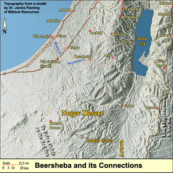
Near the "well of the oath," in various epochs, grew a town, especially in the ChalcolithicThe Chalcolithic (Copper-Stone) Age lasted from about 4000 until about 3100 BC. For the first time people were able to extract metal from ore. They managed to achieve temperatures of 1200 degrees centigrade in smelting ovens, which resulted in the separation of copper. Chalcolithic finds are numerous in this land – moreso than anywhere else in the world. period, the Iron Age, the Byzantine period and today. (The function of the ancient well has been taken over by groundwater pumps, but the source is the same mountain aquifer that extends as far north as Mt. Carmel). The town's blossoming has generally coincided with the will to press from north to south (Keel,Othmar Keel, Max Kuechler and Christoph Uehlinger, Orte und Landschaften der Bibel, Koeln: Benziger and Goettingen: Vandenhoeck and Ruprecht, 1984. Volumes I and II. p. 186). From Beersheba the aged Jacob set outGenesis 46: 1-7. Israel traveled with all that he had, and came to Beersheba, and offered sacrifices to the God of his father, Isaac. God spoke to Israel in the visions of the night, and said, “Jacob, Jacob!” He said, “Here I am.” He said, “I am God, the God of your father. Don’t be afraid to go down into Egypt, for there I will make of you a great nation. I will go down with you into Egypt. I will also surely bring you up again. Joseph will close your eyes.” Jacob rose up from Beersheba, and the sons of Israel carried Jacob, their father, their little ones, and their wives, in the wagons which Pharaoh had sent to carry him. They took their livestock, and their goods, which they had gotten in the land of Canaan, and came into Egypt—Jacob, and all his seed with him, his sons, and his sons’ sons with him, his daughters, and his sons’ daughters, and he brought all his seed with him into Egypt. with his sons toward Egypt. The kings of Judah launched from here their expeditions in quest of Arabia's riches, especially the gold of Ophir on the Red Sea. Byzantine pilgrims, in Elijah's footsteps, here began the arduous part of the journey to Sinai and St. Catherine's. The modern Israeli city (with 200,000 inhabitants) connects the rest of the land to the southern port of Eilat.
The modern city dwarfs an old well that may be the Biblical one. Called "Abraham's well," it is found in a small museum. A big tamarisk grows beside it, in memory of the one that Abraham planted. Just across the street to the south is the broad flat bed of the Beersheba River. On its banks nearby archaeologists discovered remains of six Chalcolithic settlements. Around the well, from the 11th-7th centuries BC, spread an unfortified Israelite town, whose area at times reached 22 acres.
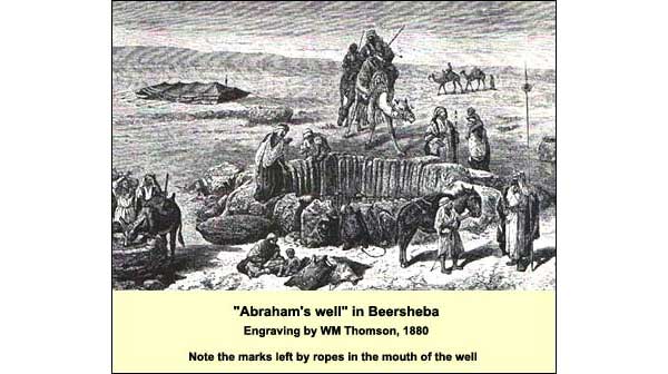
The well itself is 12 feet across and 50 feet deep. Its top 28 feet are lined with stones, set, probably, at the time of the Byzantine settlement. Below that it is hewn in bedrock. In 19th-century representations, one sees grooves in the stones, made by the ropes of the water haulers. (These top stones have had to be replaced.)
Just north of the well, on Thursday mornings, the "Bedouin market" takes place. In recent years it has undergone low-tech globalization. Off to the side, however, with luck, one can still find Bedouin buying and selling the excess from their herds. This market is the living continuation of the ancient Beersheba: a meeting place between east and west, desert and sown, where people would seal their contracts with an oath.
There is another candidate for the famous well. It too lies on the northern bank of this riverbed, but three miles to the east at Tell Sheva (see the next article).
Logistics:
Throughout the Negev, don't leave valuables in the bus or car!
"Abraham's Well" is located in a small Visitors' Center at the SW end of Hebron Road in Beersheba. The entrance is around the corner to the E, beside a large tamarisk (remembering the one that Abraham planted). Entrance is free unless you want the slide show.
For opening hours, call 08-623 4613.
{mospagebreak title=Tell Beersheba}
Tell Beersheba (Tell Sheva)
For the basic geographical position, Bible references and map, first see Beersheba.
The modern Beersheba includes "Abraham's Well," but there is another candidate. This is located three miles east at Tell Sheva (sometimes called Tell Beersheba), which sits likewise on the northern bank of the Beersheba riverbed. The tell is quite small: 2.8 acres. It contains a series of Israelite cities, one of which (from the end of the 8th century BC) has been partly reconstructed.
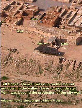
The well, oddly enough, is up on the mound, yet outside the city's single gate and protective wall. If you are going to dig a well in an unsafe place outside the wall, wouldn't you start from a point lower down, in order to be nearer the water table - that is, in order to have less to dig? As it is, this well is an extraordinary 224 feet deep (69 meters). Compare "Abraham's Well" with its 50 feet or Jacob's with 137.
A partial answer lies in two considerations. First, the well was probably dug before the building of the fortified city. Second, the city had an alternative emergency water supply.
On the first point: How can we determine when a well was dug? If the diggers penetrated through a structure, whereas the planners of another structure took the well into account - and if we know the dates of both structures - then we can say that the well was dug between these dates. (See, in general, Dating in Archaeology.) In the case of Tell Sheva, the diggers of the well dug through no structure, but the planners of the wall that protects the gate took the well into account: they were careful not to disturb it. That wall is dated to the late 10th or early 9th centuries BC. We may conclude that the well preceded it.
The diggers might have been the people of the ChalcolithicThe Chalcolithic (Copper-Stone) Age lasted from about 4000 until about 3100 BC. For the first time people were able to extract metal from ore. They managed to achieve temperatures of 1200 degrees centigrade in smelting ovens, which resulted in the separation of copper. Chalcolithic finds are numerous in this land – moreso than anywhere else in the world. era, who left pottery here. (Yet we should expect their well to have filled with windblown sand during the 2000 years when there was no settlement at the site.) Abraham might have dug it. (We have no date for him.) Or perhaps the diggers were the first 12th-century settlers, 20 or so families from the tribe of Simeon. They left grain-storage pits like those found at virtually all the small settlements from this period (see, for example, at Dan). After that, in the 11th century BC, at the time of Samuel (whose sons1 Samuel 8: 1-3. It happened, when Samuel was old, that he made his sons judges over Israel. Now the name of his firstborn was Joel; and the name of his second, Abijah: they were judges in Beersheba. His sons didn’t walk in his ways, but turned aside after lucre, and took bribes, and perverted justice. presided at Beersheba as judges), a fortified town covered half the mound. People laid out their houses in an oval, using the solid backs to form an outer wall. The well was located outside this wall on the edge of the hill. They may have dug it, but if so, wouldn't they have placed it inside their compound? The logic, then, points to the 12th century BC and the families from the tribe of Simeon.

Why didn't the diggers start lower down in the valley? Perhaps for the same reason that they chose to live where they did. The most frequent danger on this desert fringe was from nomads – for example, the Amalekites.1 Samuel 30: 1-2. It happened, when David and his men had come to Ziklag on the third day, that the Amalekites had made a raid on the South, and on Ziklag, and had struck Ziklag, and burned it with fire, and had taken captive the women and all who were therein, both small and great. They didn’t kill any, but carried them off, and went their way. Even at a time when the inhabitants lacked a wall, they had a better defensive position on the mound; they would have wanted the well nearby – not below, where an enemy could drink from or poison it.
There remains the bothersome fact that the well is on the edge of the mound, on a slightly lower level than the city. Perhaps the diggers chose this spot because it gave them the possibility of collecting runoff into it. The 8th-century planners laid out the city's streets to this end; maybe earlier planners did so too. One finds a like-positioned well at Lachish.
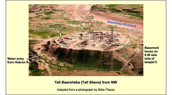
What is more, the inhabitants could do without the well in time of siege. By the 8th century BC, if not earlier, they had an emergency water system. In order to understand the latter, let us approach the tell from the air. In the photo above, we are looking southeast. Note the sharp transition from the sown to the Negev wilderness. Much of the sown is irrigated today. The source, however, is the same as that which supplied the patriarchs: local groundwater in the mountain aquifer that extends from here to the north as far as Mt. Carmel.
A yellow triangle points to the tell. The city got most of its water from the Hebron riverbed during winter rains. (Otherwise the wadi is dry.) Engineers built a dam to stop the flowing water, and they then directed it to a reservoir consisting of five cisterns
For a closer look, see the next photograph.
The reservoir can contain about 500 cubic metersOne cubic meter = 1000 liters. One liter = 1.056 liquid quarts.. The inhabitants probably kept it for emergencies, drawing from the well in times of peace. Figuring 100 people per acre, archaeologists put the population at about 300. A person can survive on one cubic meter of water annually (a thousand liters). There was enough water in the reservoir, then, to withstand a siege of more than a year.
During the same period, three miles to the west with the riverbed, there was the unfortified town of Beersheba, much bigger than this one, sometimes reaching ten times the size. What was the relationship between the two? We do not know. It seems clear, however, that the smaller, fortified Beersheba was chiefly an administrative center and military base, placed here by royal authority. In it would have lived the regional governor, his tax collectors, military officers, local guards, bureaucrats, and - we shall see - some priests. The common soldiers might have lived in long rectangular structures east of the gate. The king of Judah would have had to secure his southern border against desert nomads. This required the presence of troops to protect the main thoroughfares.
The soldiers would have also served the far flung ambitions of Solomon (r. 965-932), who sought the gold of Ophir.1 Kings 9: 26-28. King Solomon made a navy of ships in Ezion Geber, which is beside Eloth, on the shore of the Red Sea, in the land of Edom. Hiram sent in the navy his servants, sailors who had knowledge of the sea, with the servants of Solomon. They came to Ophir, and fetched from there gold, four hundred and twenty talents, and brought it to king Solomon. His emissaries needed a secure route to the port of Ezion Geber on the Red Sea, near Eilat of today. (The ancients avoided today's main route to Eilat through the Arava. It was too hot, and the mountains on both sides made the traveler vulnerable to ambush.) Solomon, or David before him, established a network of forts and outposts thrusting deep into the central Negev, as far as the Ramon Crater (Makhtesh Ramon) and the oasis of Kadesh Barnea (see map below). The "anchors" would have been the bases at Beersheba and Arad, which straddled the two southern roads leading up to Hebron.
A few years after Solomon's death, around 923 BC, Pharaoh Shishak (Sheshonk) swept through the land. It was he, apparently, who destroyed the network of forts and outposts, including the base at Tell Sheva. (Shishak left us a list of conquered cities; in the section devoted to the Negev appears the name pa'ha-q-ru-a 'i-bi-ra-ma, which may be interpreted "fortress of Abraham.") The three main centers were soon rebuilt: Beersheba, Arad and Kadesh Barnea.
It was probably Jehoshaphat of Judah (r. 870-848 BC) who restored Tell Sheva, for he too built ships at Ezion Geber1 Kings 22:48. Jehoshaphat made ships of Tarshish to go to Ophir for gold: but they didn’t go; for the ships were broken at Ezion Geber. on the Red Sea. After his death the Edomites took Ezion Geber, but in the following century, Uzziah of Judah won back Eloth2 Chronicles 26: 1-2. All the people of Judah took Uzziah, who was sixteen years old, and made him king in the place of his father Amaziah. He built Eloth, and restored it to Judah, after that the king slept with his fathers. on the Red Sea. It was he, most likely, who refortified Beersheba to secure his passage to the south. In that case, his is the city whose partial restoration we see on the tell today.
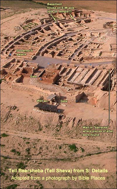
This administrative center and military base was laid out on an orderly pattern, indicating central planning. The outer row of houses doubled as a casemate wall.A wall consisting of two parallel walls, joined by buttresses that thus formed chambers. In time of need, these chambers could be filled to strengthen the wall. Otherwise they could be used for storage, or people could live in them (the Jewish rebels on Masada, for example). The inner gate, with side chambers typical of Iron Age cities, led into a courtyard, which was dominated by a large building to its left - call it the "Governor's palace." (It is the only building from this period featuring ashlarsStones cut to fit into a construction, and it seems to have had two stories.) To the right (east) of the inner gate are three long rectangular buildings, each with two rows of pillars. Such buildings are found at many sites of this time, e.g. Megiddo, Hazor, and Tell Hadar on the Sea of Galilee. Scholars debate their function: were they stables, storage chambers, shopping malls? In the easternmost room, much pottery was found, not merely storage jars but also cooking pots, dishes, and bottles. This has led to the interpretation that one or two of the rooms may have served as barracks, while the rest could have been a stable.
In one wall of the "barracks," the archaeologists noted three deliberately rounded stones (sandstone, not limestone as in the rest of the site). These proved to be the horns of an altar. (A fourth turned up with the horn broken off.) More pieces of recycled sandstone were later found. It was possible to reconstruct the altar to its height, which amounts to 1.57 meters or exactly three Egyptian royal cubits (at 524 mm. per cubit = 20.63 inches). The length and breadth are less certain. Three royal cubits was the height of the altar prescribed in the Book of Exodus.Exodus 27: 1-2. "You shall make the altar of acacia wood, five cubits long, and five cubits broad; the altar shall be foursquare: and its height shall be three cubits. You shall make its horns on its four corners; its horns shall be of one piece with it; and you shall overlay it with brass." (Compare the altar found in Arad.)
At the entrance to the site one sees a (somewhat misleading) replica of the reconstructed altar. Only the horns and the height are reliable.
How are we to understand this dramatic find? There was an Israelite sanctuary at the small Beersheba military base, just as there was at the base in Arad. Both centers were protecting Judah's southern border. They stood, respectively, on the southwestern and southeastern roads toward Hebron and Jerusalem. People did not want to rely on military force alone: they wanted divine protection, so they erected sanctuaries at their borders. This also explains the high places at Dan and Bethel on the borders of the northern kingdom. On a smaller scale, it accounts for the shrines in the gates of the cities.
Beersheba's altar was probably destroyed in a religious reform. The Bible records a reform by King Hezekiah around 715 BC and another by Josiah in 621. By most accounts, the 8th-century city was the last. The reformer, in that case, must have been Hezekiah, who "removed the high places, and broke the pillars, and cut down the Asherah: and he broke in pieces the bronze serpent that Moses had made; for in those days the children of Israel burned incense to it; and he called it Nehushtan" (2 Kings 18:4). Here too at Beersheba he dismantled the altar. One of its recovered stones, in fact, contains the engraving of a serpent!
At Arad the altar stands in its temple. No such temple was found at Beersheba. One building, however, had deep foundations: four meters, as compared with half a meter for the others. It lies on an east-west axis, like the other Israelite temples we know (in Arad, Jerusalem, and Shechem). If this was the temple in which the altar stood, Hezekiah's people tore it down to the foundations. Two of the rooms were scooped out and used as basements. It is known on the site as the basement house (captioned in some of the photos above).
Hezekiah made his religious reform as part of his revolt against Assyria. He appears to have wanted to unify the people by getting rid of their local cults and centralizing worship in Jerusalem. No one is certain how the fortified Beersheba met its end, or when exactly, but quite possibly it was one of the forty-six strong-walled cities in Judah that the Assyrian Sennacherib boasted of having destroyed (in his famous prism, column 3, line 18).
Logistics:
Throughout the Negev, don't leave valuables in the bus or car!
Tell Sheva is a national park.
Telephone: 08-646 7286
Nature Reserves and National Parks (Main office: 02/500-5444)
Opening hours:
April 1 through September 30, from 8.00 - 17.00. (Entrance until 16.00)*
October 1 through March 31, from 8.00 - 16.00. (Entrance until 15.00)*
*On Fridays and the eves of Jewish holidays, the sites close one hour earlier. For example, on a Friday in March one must enter by 14.00 and leave by 15.00.