Arad (Tell Arad)
The Early Bronze City (3000 - 2650 BC)
The Beersheba "depression" or "basin" makes for relatively easy travel from Arad (1) westward to the trunk road leading to Egypt and (2) eastward to the Dead Sea (one kilometer down). In addition, the only good road through the central mountain range splits in two at Hebron, one branch descending to Beersheba, the other to Arad. At Beersheba, however, there was no city in the Early Bronze Age (EB). With the rare exception of Jericho, we stand at the beginning of urbanization in the land. "Arad" (we don't know its name in this period) lorded it alone in the basin as an urban emporium, exchanging copper from Sinai for the wine, olive oil and grain of the north. Much of the pottery attests to Arad's connections with Egypt and the copper-producing settlements in Sinai. In the north Arad could connect to city states such as Ai, Jericho, Yarmuth, Gezer, Megiddo, Beth Shean, Hazor and Dan.
In addition to wine and olive oil, Egypt wanted asphalt for waterproofing ships and mummification, and asphalt could be had in the Dead Sea. When the earth trembled in the southern part of that deep rift, pieces of bitumen (asphalt) would break away and float to the surface. Presumably, the "Aradians" exported it to Egypt. They deposited chunks of bitumen under the floor of one of their temples - as an offering perhaps.
At the time of the earliest city here, urbanization was well underway on the Upper Euphrates, under Sumerian influence, and Egypt had just entered its first historical period. (One pottery shard at Arad is incised with the name of Narmer, first pharaoh of the first dynasty, who reigned around 3100 BC.) It was a time of population growth. On the basis of archeological surveys, the number of people in the land at this time has been estimated at 150,000 (MazarAmihai Mazar, Archaeology of the Land of the Bible: 10,000 - 586 B.C.E., New York: Doubleday, 1990 p. 112). Such growth was spurred by the domestication of livestock, which made possible a more intensive agriculture.
At Arad, for example, archaeologists found the bones of sheep and goats all over the site. There were cattle bones too, indicating use of the plow. The bones of asses testified to the main means of long-range transport. (The horse and camel were not yet domesticated.) Under Ruth Amiran, the Arad archaeologists also found carbonized wheat, barley, peas, lentils, chickpeas, flax seeds and olive pits. Here was a thriving city center, surrounded (a survey has indicated) by villages.
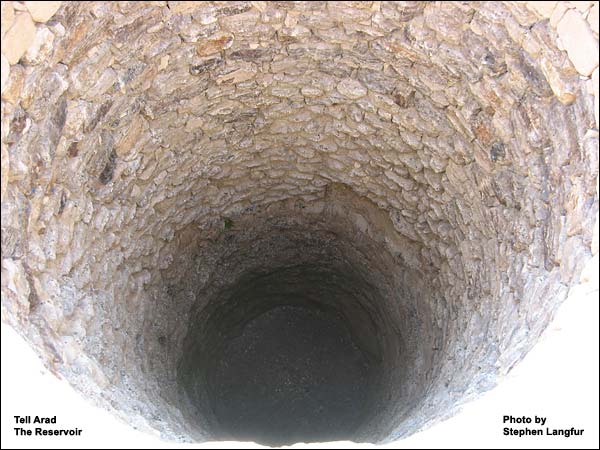
About 2850 BC, the inhabitants built a wall along the watershed of the natural amphitheater. They laid out a network of streets in such a way that all rain falling within the wall would flow downhill to the reservoir, then an open pool of about 1000 square meters. Near it they erected public buildings. The planning was meticulous, as it would have had to be to maintain 2500 people (figuring 100 per acre) despite occasional years of drought and attacks by nomadic tribes.
Except for the Israelite fortress, no one ever built here again. Nor has rainfall-erosion taken the toll it has elsewhere. The ruins, therefore, are in a good state of preservation.
Enlarge the photo, right, to see another view, from the north and closer in.
Note again the city wall running along the watershed, and how the radial pattern would enable water to flow through the streets to the reservoir. More than a kilometer long, the wall would have required a great many soldiers to defend it; no doubt the villagers took refuge in the city and provided troops as well. The wall was probably at least 12 feet high. Its two courses were filled with rubble. From it protruded 35 - 40 towers, which enabled the defenders to shoot at attackers who might try to take cover up against it. These attackers were probably desert tribes such as the later Amalekites, although there may have been occasional problems with Egypt too. The diggers found ash from a major destruction around 2800 BC. The city was then rebuilt.
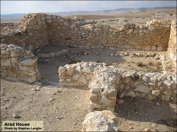
In addition to the pottery, the city's architecture illustrates its contacts with north and south. Its twin temples were similar in design to those at Megiddo in the north, also from this period. Yet the houses were very like contemporaneous dwellings found in southern Sinai.
Looking into these houses, we can get a feel of what life was like almost 5000 years ago. They all have a similar form (again, central planning at work): from an outer courtyard, where most of the daily chores took place, you took a single step down into the main room, which was rectangular with benches on the sides.
On the benches were vessels. In the middle of the room was a wooden pillar on a stone base. This pillar supported a beam that ran the length of the roof; the roofing material could span the space between each long wall and the beam. The archaeologists even found a clay model of such a house. It shows a runnel around the door, which would have directed the rain away from the opening into the street; thence it would have flowed to the reservoir. Houses of a similar plan have been found in the copper-producing EB settlements of southern Sinai, whose granite shows up in pottery shards found in Arad (as Arad pottery shows up there).
The smaller finds at Arad may be viewed at this link. Of special interest is the photograph labeled "stele": it may represent the dying and rising vegetation god. If you enlarge it, you will see two stick-like figures incised on rock. Both have hands and heads that resemble ears of grain. One is lying on a mat or bed (or in a grave?), while the other is vertical. They cross at the region of the loins, which has led some scholars to think that we have here, rather, the depiction of a heavenly union, a marriage of gods.
We are not sure what led to the city's final destruction. One or several factors may have had a part. The climate became drier in the middle of the third millennium BC. Also, Egypt became more active in southern Sinai at this time, perhaps undermining Arad's exclusivity as a trade emporium. And of course there were the ever-hungry desert nomads.
Logistics:
Throughout the Negev, don't leave valuables in the bus or car!
Arad is a national park.
Nature Reserves and National Parks (Main office: 02/500-5444)
Opening hours:
April 1 through September 30, from 8.00 - 17.00. (Entrance until 16.00)*
October 1 through March 31, from 8.00 - 16.00. (Entrance until 15.00)*
*On Fridays and the eves of Jewish holidays, the sites close one hour earlier. For example, on a Friday in March one must enter by 14.00 and leave by 15.00.
One needs a hat, good walking shoes, and plenty of water.
{mospagebreak title=Israelite Fortress}
The Israelite Fortress
Whenever the Kingdom of Judah sought to extend its reach to the Red Sea in quest of the gold of Ophir,1 Kings 9: 26-28. King Solomon made a navy of ships in Ezion Geber, which is beside Eloth, on the shore of the Red Sea, in the land of Edom. Hiram sent in the navy his servants, sailors who had knowledge of the sea, with the servants of Solomon. They came to Ophir, and fetched from there gold, four hundred and twenty talents, and brought it to king Solomon. it depended on two military bases at the gates of the desert: one at Beersheba, the other at Arad. What determined their exact placement? First, each stood in the east-west basin separating the Judean highlands in the north from the Negev desert in the south. Second, the main north-south road from Jerusalem stretched down the central mountain range, splitting into two branches near Hebron. At the intersection of its western branch with the east-west basin arose Beersheba. At the intersection of its eastern branch with the basin arose Arad. (More at Tell Arad and Beersheba.)
The same geographical factors made Arad important to Judah's foes, such as the Edomites: by capturing this spot (as well as an even bigger fortress called Ramat Negev, nine miles to the southwest), they could gain access northward to Hebron and northwest to Lachish and the Shephelah. This strategic fact gave the Judeans an additional motive to fortify the place.
After the demise of Early Bronze (EB) Arad, fifteen centuries passed and not a soul lived here. In the 11th century BC, a village arose on the high part of the tell. (Its inhabitants used some of the 1500-year-old houses.) In the 10th century, Solomon set his eyes on the gold of Ophir and replaced the village with a fortress. He may have included a temple. So thought Y. Aharoni, the site's first archaeologist, but Z. Herzog, re-assessing the finds, dates the temple to the 9th century BC. Whoever built it and used it was unaware, perhaps, of Deuteronomy 12: 13-18.Take heed to yourself that you don’t offer your burnt offerings in every place that you see; but in the place which Yahweh shall choose in one of your tribes, there you shall offer your burnt offerings, and there you shall do all that I command you.
A few years after Solomon's death, around 926 BC, Pharaoh Shishak (Sheshonk) swept through the land and destroyed many cities and bases, among them Beersheba and Arad. Both were rebuilt half a century later, probably by Judah's King Jehoshaphat,1 Kings 22:48. Jehoshaphat made ships of Tarshish to go to Ophir for gold: but they didn’t go; for the ships were broken at Ezion Geber. who, like Solomon, directed his eyes toward Ophir. The original temple probably dates to this time. Before we continue with the history, then, let us go in and have a look at it.
The Temple
The fortress we visit today, with temple intact, is largely that of the 9th and 8th centuries BC. It is a square of 52 meters on each side.
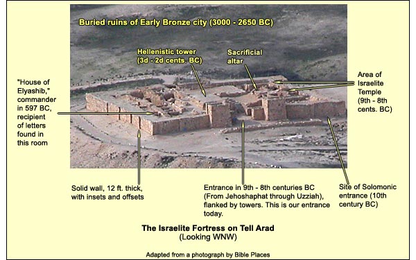
We go in through the 9th-century entrance, flanked by towers jutting out 15 feet, and ascend a few steps to stand on the remains of a Hellenistic tower (3d - 2d centuries BC), from which we can get a good overview of the Judean temple.
The temple takes up about a fifth of the precious space in the fortress. The motive for its building must have been to ensure God's presence on the border to protect the kingdom. (An earlier Kenite sanctuary?According to Judges 1: 16, Kenites made their way up from the Arava to Arad. This has led some to identify the village preceding the fortress as a Kenite establishment. Below the floor of the Judean temple, archaeologist Y. Aharoni found what he and others interpreted as an altar and, south of it, a circular high place. B. Mazar then suggested that this Kenite sanctuary may have established the holiness of the site for the Judeans. (The Kenites were a Midianite clan, and Moses had ties to the Midianites.) On re-evaluating the finds, however, Z. Herzog suggests that they may have been ordinary domestic installations: a wall and a silo. Arad's position on Judah's natural border, at the gateway to the desert, was sufficient to motivate the building of a temple: that God might be here to protect the kingdom.) Accordingly, we also find a sanctuary at Beersheba. On Judah's northern border stood, of course, the Jerusalem temple. The northern kingdom of Israel likewise had border sanctuaries: at Dan in the north and Bethel in the south. On a more local scale, cities had shrines in their gates.
The Arad temple faces west, like the one in Jerusalem and like the original "Temple of the Lord" at Shechem. In contrast, Canaanite temples from the Late Bronze Age (1550 BC – 1200 BC) had a north-south axis.
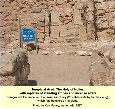
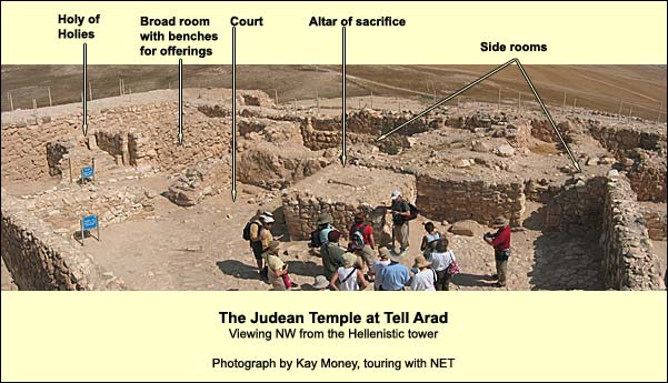
At the temple's western extremity is a niche that harbored two standing stones (matzevot). The larger was painted red. In front of them were two small altars, well preserved, traces of ash still on them. The relative positions of altars and stones suggested to the archaeologists that larger was in line with larger, smaller with smaller. (We see a replica. The originals are at the Israel Museum, where the smaller standing stone is now displayed as part of the back wall.)
This niche must have been the Holy of Holies. Its equivalent in Jerusalem, we recall, held the Ark of the Covenant, containing the tablets with the Decalogue and surmounted by the Cherubim, forming a throne for the invisible God.
Why two standing stones? One thinks of the tablets. But why the line up: large stone to large altar, small to small? A. MazarAmihai Mazar, Archaeology of the Land of the Bible: 10,000 - 586 B.C.E., New York: Doubleday, 1990 (p. 497) suggests that we have here a reference to Yahweh and his consort, Asherah, who appear together elsewhere in Israelite inscriptions. The great religious reforms had not yet occurred.
In front of the Holy of Holies are the remains of a broad room with plastered benches on the sides, probably for offerings. Coming from the east, one entered it between two pillars reminiscent of Boaz and Jachin1 Kings 7:21. He set up the pillars at the porch of the temple: and he set up the right pillar, and called its name Jachin; and he set up the left pillar, and called its name Boaz. in the Jerusalem temple; the archaeologists found their bases (not visible today). This room measures 2.7 meters from east to west and 9 meters from north to south. The latter figure is significant. Taking the common cubit at 17.5 inches, 9 meters make 20 cubits: exactly the breadth of the sanctuary in Jerusalem. The length of 2.7 meters equals 6 cubits, compared to 60 for the length in Jerusalem. Thus the basic concept of the Arad sanctuary is that of a broad-room temple, which brings the worshipper close to the deity, in contrast with the long-room form of the Jerusalem temple, which emphasizes the deity's distance, hiddenness, mysteriousness, and majesty.
East of the broad room are the remains of an open courtyard containing an altar built of unhewn stones.Deuteronomy 27: 6-7. You shall build the altar of Yahweh your God of uncut stones; and you shall offer burnt offerings thereon to Yahweh your God: and you shall sacrifice peace offerings, and shall eat there; and you shall rejoice before Yahweh your God. It measures 2.40 X 2.20 meters and stood 1.20 meters above the floor of Jehoshaphat's temple. (Uzziah later raised the floor.) These dimensions are tantalizingly close to those prescribed for the altar in the Book of Exodus.Exodus 27: 1-2. "You shall make the altar of acacia wood, five cubits long, and five cubits broad; the altar shall be foursquare: and its height shall be three cubits. You shall make its horns on its four corners; its horns shall be of one piece with it; and you shall overlay it with brass.". (The altar in the Jerusalem temple was much bigger.) On its top lies a flint flagstone sloping downward to the east. Plastered channels surround it: no doubt to collect the blood of the sacrifice. No burnt offerings were made here - the flint would have cracked in the heat, and there are no signs of burning in the surrounding clay. The altar was used for slaughter.
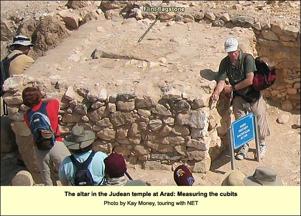
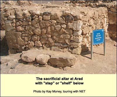
At the altar's base on the south is what looks like a step, which Aharoni interpreted as a vestige of an earlier , Solomonic altar. After probing, Herzog concluded that there was probably no previous altar. The "step" may have been a shelf for utensils, or it may have served short priests. As a single step, it would not have been a violation of Exodus 20:26.Neither shall you go up by steps to my altar, that your nakedness may not be exposed to it.’
Back to the history
Jehoshaphat's fortress was soon destroyed. It was rebuilt by Uzziah, who retook Eloth on the Red Sea from the Edomites:2 Chronicles 26: 1-2. All the people of Judah took Uzziah, who was sixteen years old, and made him king in the place of his father Amaziah. He built Eloth, and restored it to Judah, after that the king slept with his fathers. that is, he too cast his eyes toward the gold of Ophir. He raised the floor, however, so that the sacrificial altar protruded only 16 inches above it.
To secure the water supply, the builders dug reservoirs inside south of the temple. The inhabitants brought water from cisterns in the area, especially one at the site of the natural catch-basin that had served the Early Bronze city. They poured it into an opening, still visible, in the lower part of the western wall.
The date of the Arad temple's destruction is disputed. According to some scholars, in 715 BC Hezekiah undertook a major religious reform as part of an effort to "homogenize" the realm in preparation for revolt against Assyria. He centralized religious activity in Jerusalem. "He removed the high places, and broke the pillars, and cut down the Asherah" (2 Kings 18:4). Archaeologist Ze'ev Herzog reports that the temple at Arad was very carefully dismantled. "Unlike the other buildings, no indication of violent destruction is observable in the temple area. The vertical disposition of the altars and the stelae and the superb preservation of the limestone incense altars and the top of the sacrificial altar indicate that the temple was intentionally dismantled. The upper parts of the walls were torn down and the whole area was buried under a thick layer of soil." (Herzog,Ze'ev Herzog, "Arad: Iron Age Period" in Eric M. Meyers, ed.,The Oxford Encyclopedia of Archaeology in the Near East, Oxford University Press, 1996 p. 175.) Other scholars date the dismantling and burial of the temple to Josiah (621 BC) or decades after him; they see these acts either as poart of Josiah's reform (centralization of the cult) or as an attempt to protect the holy place from desecration by the Edomites or Babylonians.
Returning to the time of Hezekiah: In 701 BC, the Assyrian Sennacherib, provoked, swept down to quell the revolt. He boasted (in his famous prism, column 3, line 18) of having destroyed 46 strong-walled cities of Judah. Among them were Beersheba and Arad. Hezekiah (and Jerusalem) survived, paying tribute. His son and successor Manasseh fawned on Assyria, which let him rebuild the fortress at Arad to protect his southern border.
Manasseh's version of the fortress (with or without the temple) lasted, perhaps, through the reign of Josiah. When Pharaoh Neco had Josiah executed at Megiddo in 609, the Egyptians (concerned about the rising power of Babylon) made a last ditch effort at re-establishing power in the land. They were probably the ones who destroyed the fortress at Arad - for destroyed it was. The Judeans built it up again, with a casemateA wall consisting of two parallel walls, joined by buttresses that thus formed chambers. In time of need, these chambers could be filled to strengthen the wall. Otherwise they could be used for storage, or people could live in them (the Jewish rebels on Masada, for example). wall this time (it ran right through the former temple's broad room), in the hope of withstanding the Edomites or the Babylonians.
From this period come all or most of the Hebrew inscriptions at Arad, 131 in number. They include many inscriptions on potsherds written in carbon black ink (ostraca). There are 18 short messages to the fortress commander, Elyashib son of Eshiyahu. These date to a single month, called Tebet, which began on January 16, 597 BC, when Nebuchadnezzar "was either on his way to attack Jerusalem or was already besieging it. The month was probably the last in the fortress's existence." (Lemaire,Andre Lemaire, "Arad Inscriptions" in Eric M. Meyers, ed., The Oxford Encyclopedia of Archaeology in the Near East, Oxford University Press, 1996 p. 176.) Most of these letters order Elyashib to provide food for the "Kittim," probably Greek or Cypriot mercenaries in the Judean army. Judging from the amount of food (supplied about once a week), there were 25 or so Kittim at Arad.
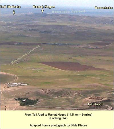
The immediate danger to Arad in 597 BC came not from the Babylonians, rather from the Edomites, who again took advantage of the fact that Judah had to concentrate its forces in the north. One of the ostraca (# 24) addressed to Elyashib reads thus: "From Arad 5 [or 50] and from Kin...[lacuna], and you shall send them to Ramat-Negev under the command of Malkiyahu-son-of-Kerab'ur and he shall place them under the command of Elisha-son-of-Jeremiah in Ramat-Negev, so that nothing happens to the city. The word of the king is binding upon you for your life! Behold, I have sent to warn you today: [Send] the men to Elisha so that Edom does not reach it."
Ramat Negev (left, identified with Tell Ira) was a larger fortress than Arad at this time, indeed the largest in the eastern Negev. Southwest of Arad, it stood on the southernmost extension of the Judaean highlands. It would have been the principal target of the Edomites in their quest for new territory. (The Edomites, for their part, were under pressure from a newly emerging people: the Nabataean Arabs.)
Tell Malhata, also pictured above, is rich in wells. It too was a Judean city at the time of the Babylonian-Edomite invasion. A third of the pottery found there was Edomite. Earlier, in the Middle Bronze Age (2000 - 1550 BC), Tell Malhata was the south-easternmost city in the land, one of a line of urban centers along what we today call the Beersheba River, which begins NW of Tell Arad and reaches the Mediterranean (under the name Besor) near Gaza.
The Edomites succeeded in occupying the Negev and the southern part of Judah, including Maresha and Hebron. The Judeans remembered their aggression and cursed them, along with Babylon, in Psalm 137:
By the rivers of Babylon, there we sat down. Yes, we wept, when we remembered Zion. We hung our harps on the willows there. For there those who led us captive asked us for songs. Those who tormented us demanded songs of joy: “Sing us one of the songs of Zion!” How can we sing Yahweh’s song in a foreign land? If I forget you, O Jerusalem, may my right hand forget its cunning. May my tongue stick to the roof of my mouth if I do not remember you; if I do not prefer Jerusalem above my highest joy. Remember, Yahweh, the children of Edom, on the day of Jerusalem; who said, “Burn it down! Burn it even to its foundation!” Daughter of Babylon, doomed to destruction, he will be happy who rewards you, as you have served us. Happy shall he be, who takes your little ones and dashes them on the rock.
Logistics: Throughout the Negev, don't leave valuables in the bus or car! Arad is a national park. Nature Reserves and National Parks (Main office: 02/500-5444) Opening hours: April 1 through September 30, from 8.00 - 17.00. (Entrance until 16.00)* October 1 through March 31, from 8.00 - 16.00. (Entrance until 15.00)* *On Fridays and the eves of Jewish holidays, the sites close one hour earlier. For example, on a Friday in March one must enter by 14.00 and leave by 15.00. One needs a hat, good walking shoes, and plenty of water.