Early Jerusalem

Here is a satellite view from directly overhead. Note the scale (lower left).
The original Jerusalem was on the spur of a hill protected by deep valleys. These were the Kidron and and to its west an unnamed valley.Called the Tyropoeon or Cheesemakers Valley by Josephus Flavius, but the expression may have been a euphemism relating to the same smell that would later give the Dung Gate its name. Cheese would not have been made in the city, rather at the sites where the livestock lived. The latter has been largely filled in by garbage and sewage, but in antiquity it was deep. The 2009 excavations show that it angles southwest from the Dung Gate; there is evidence of habitation on the hill's western slope as early as the 9th century BC. A third valley stretched from the early city's southern tip westward. This is the Hinnom, Gai B'neh Hinnom in Hebrew, which came to be called Gehenna (associated with hell).Gai B'neh Hinnom in Greek became Gehenna – an equivalent of hell. The association may have arisen out of 2 Kings 23:10, which lists the reforms of King Josiah: "He defiled Topheth, which is in the valley of the children of Hinnom, that no man might make his son or his daughter to pass through the fire to Molech." (Cf. Isaiah 30:33 and Jeremiah 7: 31-33). The associaton with hell became further established in Jewish apocalyptic literature: 4 Ezra 7:36, "The furnace of Gehenna shall be made manifest, and over against it the Paradise of Delight."
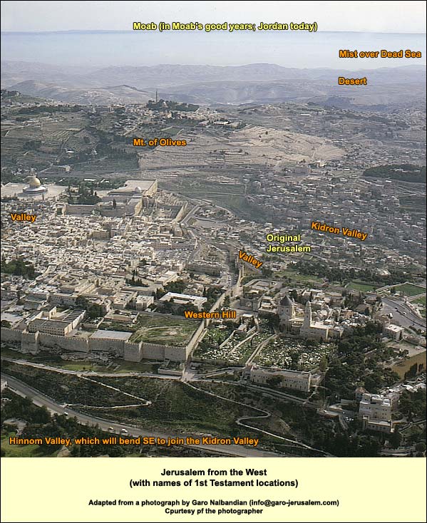
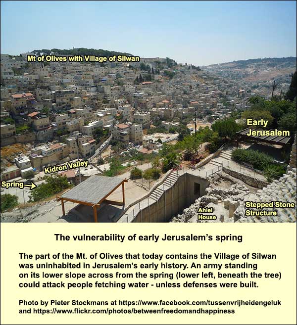
Thus the original Jerusalem had excellent natural defenses on all sides except the narrow north. Here the hill sloped upward, forcing the city's first residents to build a high wall against potential archers. This hill can be considered part of the plateau of Benjamin (to be discussed shortly). Jerusalem had a strong spring, which today produces an average of 1500 cubic metersA cubic meter=1000 liters.daily. Until the 20th century it was intermittent, but now it gets additional water from urban leakage and irrigation, with the result that it flows constantly. We know it as the Gihon, which is the name that appears in 2 Chronicles 32:30, but earlier it may have been called shiloah (sent, Isaiah 8:6) or en shemesh (spring of the sun, Joshua 15:7). It is located in an opening that now lies just beneath the floor of the Kidron Valley (which used to be deeper). In addition, the city was surrounded by watersheds (a major, curving one on the north and west, and another formed by the ridge of the Mount of Olives on the east). There would have been run-off from three sides, which was caught by cisterns in First Testament times. Here is a view from the west:
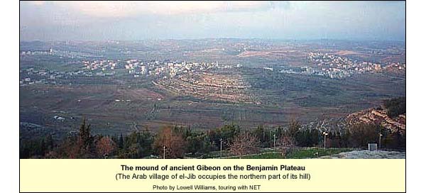
Some hold that Jerusalem was a tiny village in the time of David and Solomon. Indeed the spur is small. Yet the settlements nearby were much smaller, and the other cities on the central mountain range were not as well defended by valleys. We shall see, moreover, that long before David the city had enormous fortifications, unparalleled elsewhere in the central mountain range or indeed, some say, in the land as a whole. Jerusalem was already important enough in the 18th century BC to attract an Egyptian curse in the Execration Texts.The Egyptians wrote the names of their enemies on clay figures, which they then smashed or maltreated, hoping that a similar fate would befall those designated. What made this first Jerusalem important? The answer includes two factors. First, on its north side begins a plateau (10 miles south-to-north by 4 miles east-to-west). Since most of it belonged to the tribe of Benjamin, we can call it the Benjamin Plateau. The southernmost good link road, stretching east-west between the international trade routes, here met the only north-south route in the central highlands. Using an unbroken ridge (rare in these parts), the link road ascended from the west through the Beth Horons toward Gibeon on the plateau. Then the traveler could descend to Jericho and cross the Jordan to Heshbon on the King's Highway.
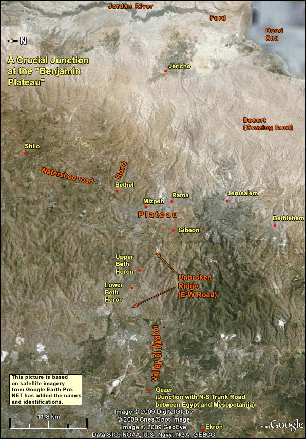
The photograph (right) shows the western part of the ridge road. Armies coming from the west to attack Jerusalem tended to take this unbroken road, reaching the plateau and turning south: for example, the Seleucids on their second attempt to quell the Maccabean revolt, the Romans under Cestius Gallus, the Crusaders, and the British in 1917. We have already seen the second reason for Jerusalem's early importance: Many other cities enjoyed the commercial advantages of the central Benjamin plateau: Bethel, Beeroth, Mizpah, Rama, Gibeon, and Gibeah, while Jerusalem clung to its southern edge. But although these other towns were closer to the intersections, only Jerusalem had deep valleys for defense.
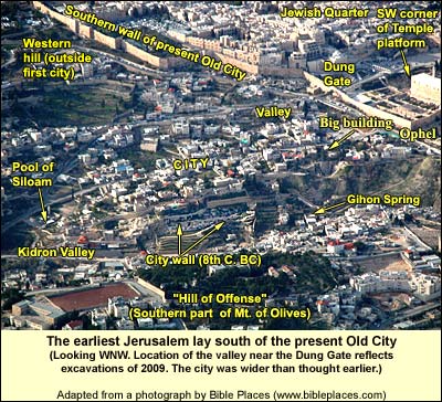
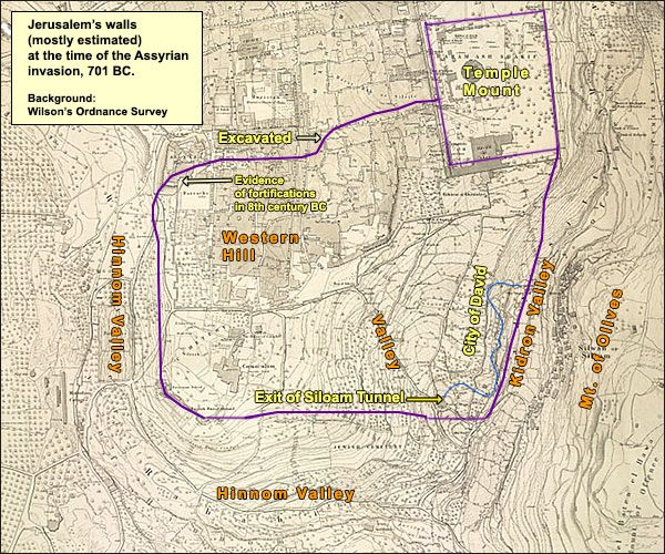
Jerusalem's access to the Benjamin plateau, combined with its defensibility, were among the factors that led David to make it his capital. David had other reasons too for choosing Jerusalem as his capital: After the death of Saul, the whole land was exposed to the Philistines. David, chief of a warrior band, went up to Hebron and ruled Judah. Hebron is ideally situated for controlling the southern quarter of the central highlands, but no more than that. According to 2 Samuel 5: 1-3, after seven years, in response to the Philistine threat, the other tribes asked David to rule over them. Hebron would not be suitable as a capital for such an expanded kingdom: it lay too far south, and its connection with the north was tenuous. Now David cast his eye on Jerusalem: it bordered his home tribe of Judah, and it gave him access to the Benjamin plateau. From here he could connect to all points. On the other hand, if he let it fall to the Philistines, he would be blocked from contact with the north. This particular Philistine threat may have been his principal motive, as KeelOthmar Keel, Die Geschichte Jerusalems und die Entstehung des Monotheismus, Göttingen: Vandenhoeck & Ruprecht, 2007, p. 171. suggests. Concerning the conquest, we read in 2 Samuel 5:6 that Jerusalem belonged to the Jebusites. When David and his forces arrived, "the Jebusite" taunted him, saying that the lame and the blind would suffice to keep him out of the city. Verse 7 says: "And David captured the Fortress of Zion, it is the City of David." (The word for "captured" can mean "ensnared.") And the next verse reads (sticking close to the Hebrew): And David said on that day, "Whoever strikes a Jebusite and touches thetzinnor,In the biblical text, tzinnor occurs only here and in Psalms 42:8, where it seems to mean something associated with water, such as a waterspout. and the lame and the blind are hated of David's soul, which is why it is said that a lame or a blind personThe verse probably refers to the fact that, as stated in Leviticus 21:17-18, Aaron's descendants who were lame or blind or had certain other physical challenges were excluded from officiating as priests in the temple. Otherwise, the lame and the blind had the same access to the temple as all Israelites: In Matthew 21:14, we learn that that lame and the blind came to Jesus in the temple, and he healed them. shall not enter the house." If the sentence about "Whoever strikes a Jebusite" sounds ungrammatical, well, it is! Usually the verse is taken to explain how David conquered the city. But notice the gap after tzinnor. No verb follows the subject-clause ("Whoever..."). Elsewhere in the Bible such a phrase introduces an expression like, "...will be put to death" (Exodus 21:12-17). One might then take the three verses, 6-8, as a chronological sequence: (6) David is taunted; (7) David ensnares the city; (8) David at once issues an edict forbidding his soldiers to harm a Jebusite or touch the tzinnor. This interpretation fits well with the fact that Jebusites continued to live in the City of David. We know they remained because David later bought a threshing floor from Araunah the Jebusite on the peak of the city's hill and erected an altar to Yahweh there (2 Samuel 24:16-25). It is remarkable that the Araunah story survived: According to Deuteronomy 7:1ff.; 20:17 (cf. Joshua 6:21) all non-Israelites were to be driven from the land or killed, and this view clearly guided the editor of the so-called Deuteronomic history (Joshua, Judges, Samuel, Kings). A continued presence of non-Israelites in Jerusalem was an embarrassment for the editor (as in Jericho and Gibeon, where suitable stories explain the anomaly). Perhaps, that is why we do not hear of any other Jebusites by name in the city (this may also explain the above-mentioned gap in the Hebrew of 2 Samuel 5:8). But it is noteworthy, as KeelOthmar Keel, Die Geschichte Jerusalems und die Entstehung des Monotheismus, Göttingen: Vandenhoeck & Ruprecht, 2007, pp. 171ff., 188-89. points out, that after David arrives in Jerusalem from Hebron, he gets an additional high priest (Zadok) to the one he had in Hebron (Aviathar) and an additional military commander (Benayah) to the one he had in Hebron (Joab).In 1 Chronicles 11:6, written centuries later, David adds that the leader of the attack will be head of the army, and this turns out to be Joab, who is already head of the army. Keel believes that the new, additional leaders were veteran Jerusalemites. He also counts Bathsheba and the prophet Nathan in this group. On such a view, the "capture" of the city may have involved an agreement: Many of the Jebusites might well have preferred David's rule over the only alternative, the Philistines. ("The Jebusite" [singular] who taunted David may have represented an opposing faction.) On "ensnaring" the city, David amalgamated his Hebron cabinet with part of the existing Jerusalem (Jebusite) leadership. He managed to hold the two groups together until his death, when the veteran Jerusalemites, led by Bathsheba's son Solomon, defeated the Hebron crowd (Adonijah and Joab were murdered, Aviathar exiled). By force or accommodation or a little of both, David assumed power in Jerusalem and made it his capital. Solomon built the Temple there. This was destroyed by the Babylonians in 586 BC but restored 70 years later by returning Jewish exiles. In 23 BC, Herod began to rebuild it in grander style. To this city and its Temple Jesus made pilgrimage around 30 AD, followed by the many pilgrims who came in his footsteps starting 250 years later. Several centuries after that, Muslims identified Jerusalem as the place of Muhammad's ascent into heaven. All these traditions have led to the growth of the metropolis that we see today. {mospagebreak title=Top of the Hill} The Top of the Hill Apart from the vulnerability of its spring (discussed on the next page), the original Jerusalem had one major defensive problem. No deep valley protected it on the north. Instead, a hill rose gradually, with the result that archers, standing on what would later be the Temple Mount, could easily attack. We can see this by noting the contour lines in the Ordnance Survey by Captain Charles Wilson (1876):
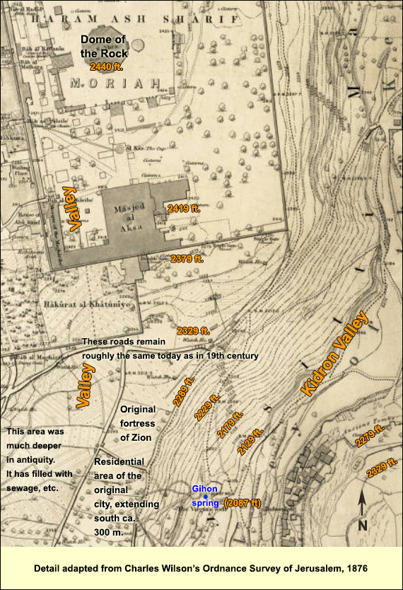
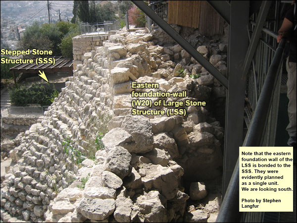
Obviously, the Jerusalemites would have needed a strong fortress on the north. In fact, at the point I have marked "Fortress of Zion" on Wilson's map above, archaeologist Eilat MazarThe Palace of King David. Excavations at the Summit of the City of David. Preliminary Report of Seasons 2005-2007 (Jerusalem). discovered, in 2005 - 2007, what she has dubbed the "Large Stone Structure" (LSS). It was built as a single unit with the longer-known "Stepped Stone Structure" (SSS), which faces the Mount of Olives on the east. In the enlargeable photograph on the right, taken from the east, you can see how the SSS merges into the wall of the LSS. The photograph below also shows that the SSS seamlessly joins the eastern foundation-wall of the LSS (in the foreground and stretching south, where it is preserved to a thickness of more than 5 meters). Although Jerusalem existed already in the Middle Bronze Age IIB (1750 - 1650 BC) and perhaps in the previous millennium (Early Bronze), Mazar's dig revealed no trace of a building on this spot from those times (she did find MB pottery, though). Perhaps the city's northern limit was south of here before the 12th century. Until the SSS was built, the fragility of the karstic bedrock may have made it impossible to build a heavy fortress this far to the north.
Here is a view from above, showing the structural unity:

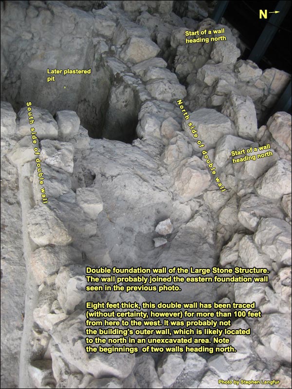
On the inside to the west, here are further foundation walls of the LSS:
Together, the SSS and the LSS amount to a massive project. But when was it undertaken? Archaeological dating is difficult in early Jerusalem for a number of reasons: a) The hill is mostly occupied by private houses, under which one may not dig. b) The slopes are so steep that ancient builders either re-used existing structures or cut back to bedrock, dumping earlier remains, so that little could be found in situ. c) Part of the hill was used as a quarry, probably in the Roman period but perhaps as far back as Nehemiah (5th century BC). d) Much of it was explored by early archaeologists. The importance of broken pottery for dating had not yet been discovered. They threw away the sherds they found. However, Jerusalem's first archaeologists avoided spots where the debris was heavy. One of these was the area beneath the entry platform of the current visitors' center, where Mazar found the LSS. She has dated the project to David, identifying it with the palace that the Phoenicians built for him (2 Samuel 5: 11). This is also the dating preferred by many guides. It is probably the reigning current opinion. Nevertheless, a close, well-argued reappraisal of Mazar's findings has been done by archaeologist Avraham Faust,"The Large Stone Structure in the City of David: A Reexamination," Zeitschrift des Deutschen Palästina-Vereins (1953-), Bd. 126, H. 2 (2010), pp. 116-130. who suggests a date in the 12th or 11th centuries BC, the time of the Jebusite "fortress of Zion" (2 Samuel 5: 6). I shall now present Faust's reasons. Several indicators point to a Jebusite date of construction. Beneath the building, Mazar found a deliberately flattened surface on top of which was an earth accumulation containing pottery from the city's earlier periods through Iron I (1200 -1000 BC or somewhat later), no later. She held that the LSS was constructed on top of the earth-accumulation. However, her cousin, archaeologist Amihai Mazar,"Jerusalem in the 10th Century BCE. The Glass Half Full," in Y. Amit et al. (ed.), Essays on Ancient Israel in Its Near Eastern Context. A Tribute to Nadav Na'aman (Winona Lake), 269-70. noted that the earth-accumulation was not just below some of the structure's walls, but also at a level even with their lower courses. That would suggest a construction date in Iron I. The season of 2006-2007 was especially important in this regard. In the floor of a room within the LSS, Eilat Mazar found a thick layer containing Iron I pottery as well as crucibles such as were used then in metallurgy. This layer continues eastward, abutting the massive eastern foundation wall (W20 in the second photo above). The joining of the crucibles-layer with this foundation wall indicates that the crucibles-layer belonged to the original building. In the layer above the crucibles-layer, she found large sherds of collar-rim jars that are also typical for Iron I. We may conclude that the building - and the whole massive project - originated at a time when Iron I still had a significant period ahead of it. In that case, the construction probably preceded David (who is generally dated to ca. 1000 BC), for in strata throughout the country, according to Faust, the emergence of the Israelite monarchy is associated with the pottery of Iron IIA (1000-900 BC), never Iron I. Why should we associate the monarchy with Iron IIA? Because, at sites that have a claim to being Israelite or Judahite, there are no indications of monumental architecture in Iron I, rather first in Iron IIA. We shall see that archaeologist Jane Cahill, who is responsible for presenting the finds from the major dig that took place here in the 1980s, dates the SSS to around 1200 BC, the start of Iron I. The LSS was likely the Fortress of Zion in which the Jebusites took pride (2 Samuel 5: 6-7And the king went with his men to Jerusalem, to the Jebusite, dweller of the land. And he said to David, "You won't come in here, the blind and the lame will stop you," which is to say, David won't get in here. And David captured the fortress of Zion, which is the City of David.). To be sure, on assuming power in Jerusalem, David could have adopted/adapted the LSS as his palace. Or it could have functioned, in whole or in part, as the city's first "House of Yahweh" (2 Samuel 12: 20;And David arose from the ground [after the death of his first child by Bathsheba], washed and anointed himself, changed his gown, and went to the House of Yahweh and prayed. cf. 2 Sam. 22: 7). It may be the case that the LSS continued in use only until about 900 BC. Although its high, flat area should have been prime real estate even after the city expanded northward (people were then building on the slopes, after all!), hardly any remains were found that could be dated to the rest of the Iron Age, to the Persian period or to the Hellenistic period. The next clear architectural features here come from Herod's time. The missing periods may be explained, however, if we take into account the fact that the Romans tended to clear a space entirely before building on it. At the eastern foot of the hill, an earlier archaeologist, Kathleen Kenyon, found a huge voluted capital (now displayed in the Israel Museum), similar to capitals from Israelite royal structures in Samaria, Megiddo and Hazor. The latter are dated, however to a century after David - a time for which, as said, very little was found in the area where the LSS had been. The Stepped Stone Structure We walk east and behold the steep drop to the Kidron Valley. Across from us rises the southern extension of the Mount of Olives. This southern part of Olivet is called the Hill of Offense, because of a legend that upon it King Solomon erected altars to the gods of his thousand pagan wives. On its steep slope today is the Arab village of Silwan, whose houses seem stacked on one another. The impression is perhaps like the one that Jerusalem offered 3000 years ago, when the houses hung thus on the slopes. In the time of the First Temple, the hill where Silwan is today was honeycombed with cave-tombs hewn into the rock. Most of them are now hidden by the houses. To judge from the workmanship, these were the tombs of the upper classes. The people of ancient Jerusalem lived facing their eminent dead. We can spot the location of the Gihon Spring at the bottom of the hill we are on. We can see that the inhabitants would have had a problem reaching it in times of siege. An enemy could stand on the other side of the narrow valley, where Silwan is today, and shoot arrows or hurl spears at anyone fetching water. We shall see how the early Jerusalemites solved this problem. Descending a staircase to what is called Area G, we turn and examine again the massive, curved Stepped Stone Structure. It continues far beneath the viewing platform. No one has been able to determine how deep it goes (or how wide it is), for much is still covered by debris from the destruction of 586 BC. Some 58 courses of masonry have been exposed, overcoming a difference in height of 17 meters, but Kathleen Kenyon, in the 1960's, unearthed what may be part of it much further down. If so, the difference in height would amount to at least 30 meters. (Indeed, 37.5 meters would have brought it up against the city wall, which would have supported it.) The probable function of the SSS was to reinforce the bedrock (which is cracked by karstic fissures), on which stood the fortress (the LSS). Where we stand the SSS is close to the bedrock that it strengthens, but below, out of our sight line, Kenyon made a probe to determine its thickness. After penetrating horizontally for eleven courses of stones, she feared a collapse and stopped. The SSS consists of a substructure and a superstructure linked by a rubble core. The substructure, writes Cahill,Jane Cahill, "Jerusalem at the time of the United Monarchy: The Archaeological Evidence," in Andrew G Vaughn and Ann E. Killebrew, eds., Jerusalem in Bible and Archaeology: The First Temple Period, Society of Biblical Literature, 2003, p. 34. Because of Shiloh's untimely death, he was not able to publish his final report; Cahill was appointed to this task. "is composed of a series of interlocking terraces formed by north-south spine walls and closely spaced east-west rib walls," creating interlocking compartments. These were "capped by a rubble core that keyed them to a superstructural mantle." This is the mantle of which we see a part, albeit interrupted by later buildings. "The stepped mantle capped and sealed the rubble core, which in turn capped and sealed the soil- and stone-filled terraces." I should mention that archaeologist Yigal Shiloh, under whom Cahill worked in the 1980's, dated the mantle to the 10th century BC but the terraces beneath it to the 14th or 13th.
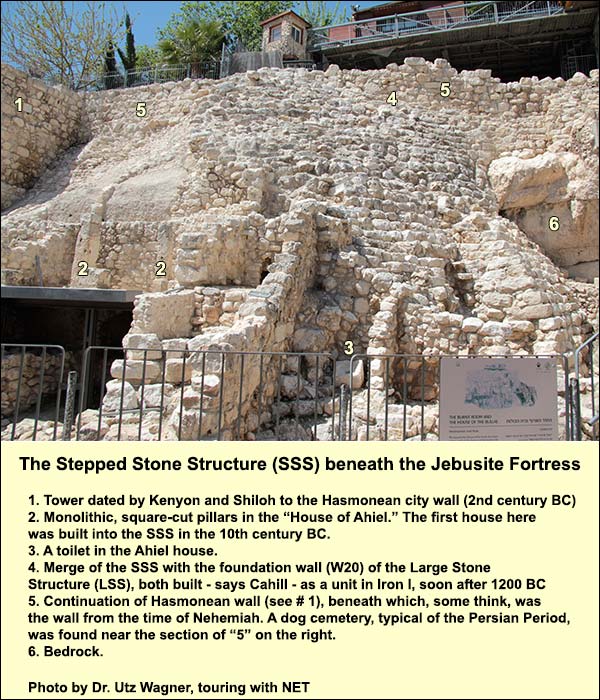
Shiloh probed into the SSS at two places. Cahill interprets the findings as evidenceJane Cahill, "Jerusalem at the time of the United Monarchy: The Archaeological Evidence," in Andrew G Vaughn and Ann E. Killebrew, eds., Jerusalem in Bible and Archaeology: The First Temple Period, Society of Biblical Literature, 2003, pp. 42-45. that the substructure, core, and mantle were built as a single unit. Shiloh also found evidence for the date of the construction. This consists of some 500 sherds from the fills of the substructures and the rubble core; the vast majority, says Cahill (here in agreement with Shiloh), are typical for the Late Bronze Age II (1400 - 1200 BC), and none are later than early Iron I, about 1200 BC, so the SSS was likely constructed not long after 1200. She reports that Shiloh found sherds from the 10th century only on top of the completed mantle. The dating of the SSS to around 1200 fits what we have seen concerning the date of the LSS, which was built, we recall, together with the SSS as a single, massive project. Here we find ourselves within the current debate, which to many will seem abstruse. In brief: Taking a different view, Eilat Mazar "tries to push the date of the LSS to the late Iron Age" (Faust, op. cit., pp. 124-25) and on this basis, she claims that the Shiloh/Cahill dating of the SSS pottery is too early. She claims that the whole structure was built during the years of transition from Iron I (1200-1000 BC or later) to Iron IIA, and she puts the reign of David in that transition. Elsewhere, however, she places David solidly within Iron IIA, as do most scholars. We may note, though, that a construction date in the first half of the 12th century makes good historical sense. It coincides with the period of the great upheaval in the eastern Mediterranean and with Egypt's consequent withdrawal from the country (ca. 1150 BC). The massive defensive project of the SSS-LSS may reflect the loss of Egypt's protection at a time when hundreds of new settlements were springing up nearby in the central mountain range. The project may explain why Jerusalem was not destroyed in the great upheaval, as were Megiddo, Hazor, and almost every other major city in the Levant. At some stage (we shall discuss the date soon), people cut into the SSS to build houses. Standing on the tourist path, looking west, we can see the remains. To the left are two squared monolithic pillars (numbered "2" in the photo above). They belonged to the west side of a house about 8 meters deep and 12 wide, which probably had a second story. (The archaeologists pulled down the remains of the east side in order to explore the continuation of the SSS.) This house, Shiloh noted, was better built, its ashlarsStones cut to fit into a construction more finely chiseled, than the houses he found in a residential area to the south. Inside was an inscribed stone weighing the equivalent of exactly 2500 shekels by the Phoenician standard (i.e., 18.971 kg.) - evidence that very large items were weighed here. (Dozens of weights were found in the next house to the south.) Just south of the pillars is part of a staircase that probably led up to the next terrace, which has since disappeared. Just north of the pillars the diggers found the remains of three service rooms, one containing 37 storage jars from the 7th century BC, the time of Jeremiah. Another small room in the house had a stone toilet (one of five found in the city of this time), still visible, which is shaped for sitting. There is a hole in its center, and beneath it is a pit about eight feet deep. (Investigation of the ancient excrement revealed that the inhabitants had worms.) Inscribed potsherds (ostraca) were also discovered in the house, written in a Hebrew script typical for Jeremiah's time. One contains the name "Ahiel," which modern scholars have used to designate this villa. Shiloh made a thorough exploration of this house and the one to its north (the "burnt room," discussed below). The dating is important, because the inhabitants would not have risked cutting into and possibly harming the SSS if it had still had its original function, namely to shore up the bedrock supporting the city's fortress (the Large Stone Structure or LSS). By the time this residential quarter was built, in other words, the fortress had probably become irrelevant - i.e., the city had expanded northward. Using the Bible and geographical logic, one would think that the expansion occurred when Solomon built his palace and temple, because the only viable place for such big buildings would have been in the area of today's Dome of the Rock. Excavation is not permitted there, but thorough excavations have occurred in the area between the City of David and the al-Aqsa Mosque. (This area is today called by the biblical term "the Ophel" - a modern mistake so deeply embedded that I shall perpetuate it here; Norma FranklinFranklin, Norma. "Dispelling the fog around the Ophel ," in Noor Mulder, Jeannette Boertien, & Eveline van der Steen (Eds.), Exploring the Narrative: Jerusalem and Jordan in the Bronze and Iron Ages, pp. 286-296 (London: Bloomsbury T&T Clark, 2014) has made a persuasive case that the biblical term Ophel signified the SSS.) Now here's the rub: hardly any pottery preceding the 8th century BC has been found in the Ophel. This fact might lead us to think that the city did not expand northward until then (and that the writer of Kings, working in the 7th century BC, misattributed to wise and wealthy Solomon the 8th-century structures he saw on the peak). On the other hand, as Cahill likes to point out, absence of evidence is not evidence of absence. By dating the houses in the SSS, we can get at least circumstantial evidence as to when the city's northward expansion occurred. I quote from an abbreviated version“Jerusalem in David and Solomon’s Time.” Biblical Archaeology Review, Nov/Dec 2004, 20-29, 31, 62-63. http://members.bib-arch.org/publication.asp?PubID=BSBA&Volume=30&Issue=6&ArticleID=5 of Cahill's article, dating the houses in the SSS to the 10th century BC: Each of these houses exhibited more than one phase of occupation, shown by multiple floors laid one atop another. The earliest in both cases was the floor of Stratum 14—from the time of the United Monarchy. The pottery assemblage from the Stratum 14 floor cleared in the Burnt Room House includes an imported Cypro-Phoenician bichrome flask that clearly dates to the earliest phase of Iron Age II [Iron Age IIA, 1000 - 900 BC or later - SL]. In addition, there was a substantial amount of local pottery traditionally dated to the tenth century B.C.E. (Although Israel Finkelstein, arguing for a low chronology, might date this pottery to the ninth century B.C.E., the assemblage is closely comparable to the pottery assemblage from Stratum 12 at Arad, to which all scholars—including Finkelstein—attribute a date in the tenth century B.C.E.) We recall that the Large Stone Structure appears to have been defunct by 900 BC. Thus we have indirect evidence for a 10th century expansion of the city to the north. About 5 yards north of Ahiel's house, there is part of a second staircase adjoining the wall of another structure. Archaeologists call this "the burnt room," for they found many lumps of carbonized wood in it. These included finely worked pieces of boxwood (not native) with motifs such as the palmette, also known from the ivories of this time. Mixed among the pottery sherds were arrowheads of bronze and iron. The impression is one of battle and fire, and to this we can relate the destruction by the Babylonians in 586 BC, as told in 2 Kings 25:8-9: Now in the fifth month, on the seventh day of the month, which was the nineteenth year of king Nebuchadnezzar, king of Babylon, came Nebuzaradan the captain of the guard, a servant of the king of Babylon, to Jerusalem. He burnt the house of Yahweh, and the king’s house; and all the houses of Jerusalem, even every great house, burnt he with fire. cb(25,10); East of Ahiel's, beneath the path we stand on, the diggers discovered another burnt house with arrowheads from that day… and more: 49 bullae, i.e., clay seals from the letters received by the person who lived in this dwelling. The fire had burned the letters and baked the seals. 45 of the 49 consist of names without images, often including a variant on the name Yahweh - e.g., Gemar-yahu son of Shaphan, mentioned in Jeremiah 36: 1-12. In their avoidance of images they resemble 211 bullae and seals that were bought from antiquities shops (including some fakes, no doubt) by various people in the mid-1970's. These were published by Nahum Avigad,Hebrew bullae from the time of Jeremiah, Jerusalem: Israel Exploration Society, 1986 who dated them on paleographic and onomastic grounds to ca. 600 BC. Taking the two collections together, 89% consist of writing only. (Of the rest, some are heirlooms and others do not go beyond figures of plants.) This fact is important because it demonstrates the historicity of King Josiah's reform (621 BC), which banned graven images.Deuteronomy 5:7 in accordance with the part of Deuteronomy discovered in his day.2 Kings 22-23 The ban stands in stark contrast with the continued use of images in neighboring lands. But not only that. It also contrasts with the situation in Judah and Jerusalem before Josiah, when images abounded. They appeared not only on seals and bullae: excavation has brought forth, from almost every pre-Josianic house in Jerusalem and Judah, a small, rather standardized statue of a fertility goddess, whose function no doubt was to help with childbirth, and who may have been modelled on a statue of Ashera in the temple (KeelOthmar Keel, Die Geschichte Jerusalems und die Entstehung des Monotheismus, Göttingen: Vandenhoeck & Ruprecht, 2007, pp. 478-82, 548-52.). Forty-eight years after the Babylonian destruction, the edict of Cyrus allowed the exiles to return and rebuild the Temple. Under Nehemiah (5th century BC), the city wall too was rebuilt, although it enclosed a much smaller area than before the Babylonian destruction. Shiloh found no trace of Nehemiah's wall (against an earlier interpretation by Kenyon), but he did find many sherds from the Persian period, including 23 jar handles stamped with a striding lion that may perhaps be attributed to Nehemiah. According to both Kenyon and Shiloh, it was the HasmoneansThe Hasmoneans: family of Judah Maccabee ("the hammer") and his brothers, who revolted successfully against the Greek Empire in 167 BC. They purified and re-dedicated the Temple in Jerusalem, establishing the festival of Hanukah ("dedication"). They ruled till 63 BC, and their domain extended almost as far as King David's., three centuries after Nehemiah, who built the wall to which belongs a tower that adjoins the upper part of the SSS. Most Jerusalemites at the time of the Hasmoneans lived on the larger hill to the west; there was no longer a need to build houses on the steep slope, so the wall could run this high up, near the spine of the hill. Nehemiah's famous wall, built in 72 days, may lie beneath the Hasmonean wall (# 5 in the photo on the right, which you can click to enlarge). We shall now head downhill to see how the people of the first Jerusalem defended their water supply. {mospagebreak title=Water systems} Early Jerusalem's water systems We have noted the vulnerability of Jerusalem's spring: an army on the Mt. of Olives, across the narrow Kidron Valley where the village of Silwan is today, could make things unpleasant for anyone going to fetch water. How did the first Jerusalemites come to grips with this problem? First, here is an overview looking southeast. The position of the spring is indicated on the lower left side.
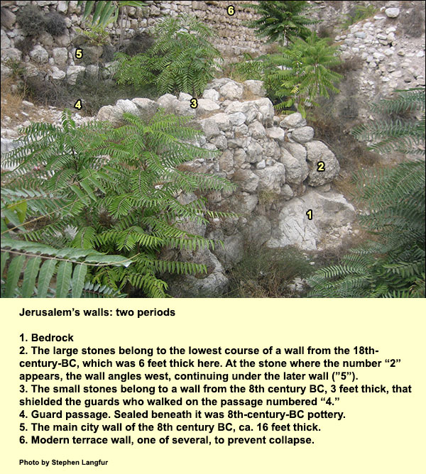
In the Middle Bronze Age IIB, meaning roughly 1750-1650 BC, the Jerusalemites dug to the water from a point high up, inside their city wall. We shall now study their work in detail. We head south from the Stepped Stone Structure until a staircase appears on our left. We descend it, passing the entrance to the underground water system ("Warren's shaft"), until, three-quarters of the way down the steps, we find an assemblage of stones on our left (north of us). For decades they have been understood as belonging to earlier city walls, as explained in the picture below. On studying the pottery in 1967, archaeologist Kathleen Kenyon was able to date the older to the Middle Bronze IIB. This period (again, 1750-1650 BC) will be coming up often in what follows, so we shall refer to it as "MB" for short. At "2" in the photo below, the MB wall angles westward, continuing under a wall ("5") from a thousand years later. The turn suggests that the northeast corner of MB Jerusalem may have been here (which would fit the surmise that the Stepped Stone Structure later extended the city northward). But the turn could have been part of a recess or part of a tower. (Fearing collapse, Kenyon could not follow the wall farther west to find out.) In the light of his recent excavations with Eli Shukron, however, Reich, Ronny. Excavating the City of David: where Jerusalem's history began. Israel Exploration Society, 2011, pp. 255-260.Ronny Reich suggests that Kenyon's "city wall" seems rather minor compared with the very massive MB walls they found near the spring, walls they believe extended on an east-west line right up to the top of the hill. We'll discuss this later.
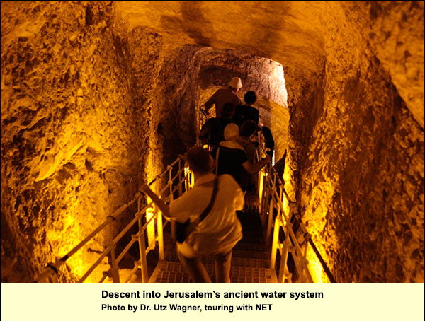
The stones in the MB wall are large, such as only a giant can move, one might think. Such construction is therefore called cyclopean, after a famous giant in Homer's Odyssey. We shall find many such stones after we pass through the underground water system, in the fortification that led to and guarded the spring. We climb back up the steps to the opening of Warren's Shaft. People use this term today to mean the entire underground access system, not just the vertical opening near its end (which I shall distinguish by calling it "Warren's vertical shaft"). Charles Warren, an intrepid British explorer, discovered and cleared most of the system in 1867. The MB Jerusalemites, we have seen, had a problem in reaching their spring during a siege. They solved this by gaining access to it from inside the city. The wall and the shaft were part of one plan. It may be that karstic processes had already done some of the work: there are many karstic fissures in this limestone hill. (On karst.) That is, rainwater picking up carbon dioxide forms carbonic acid, which over a long period dissolves some of the limestone. We descend a staircase into the water system. The purpose of hewing so steep a decline was to stay far below the surface, thus ensuring that the shaft would not destabilize the heavy wall above.
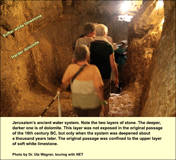
When we reach the bottom of the steps, where the route becomes more horizontal, we are at the point where two teams of hewers met about 3700 years ago, one coming from above and one from the direction of the spring; maybe they poured colored water and followed it as it dripped through the fissures. Continuing, we begin to notice that the height increases and that a difference appears in the shading of the bedrock on the sides. There is an upper layer of soft white limestone, called meleke (royal) because of its high quality, and there is a lower layer of harder, darker dolomite on which we are walking. Only during the excavation by Reich and Shukron, conducted since 1997, have we come to realize that the MB shaft was cut only through the soft white stone of the upper layer. In other words, when Jerusalemites went to fetch water 3700 years ago, they did not walk where we are walking: they were higher; the top of the dolomite layer served as their floor.
Ahead of us is a ladder. When we climb it, we shall enter a passage which was simply the continuation of the one from the 18th century BC. This passage led, we shall see, to a point above a rock-cut pool that collected the water of the spring. There you could cast your waterskins. Before we climb the ladder, however, we face the question: who deepened the passage into the harder, darker stone, when, and why? As to when, the answer lay on the floor of the older MB passage we shall reach with the ladder. Here Reich and ShukronReich, Ronny. Excavating the City of David: where Jerusalem's history began. Israel Exploration Society, 2011, p. 157. found a thick deposit of stone chips from the harder dolomite layer, but none from the soft white meleke. They also found sherds of three oil lamps which they dated to the 8th century BC. So the 8th-century inhabitants had dug the passage deeper but had not finished clearing out their dolomite chips. But why were they digging? Perhaps the MB system seemed vulnerable in the light of the military technology of their time. That system depended, we shall see, on the strength of an exposed tower that was attached by a massively built corridor to the rest of the city. Indeed, perhaps an earthquake had damaged it. In any case, the Jerusalemites would surely have preferred a seamless tunnel directly to the spring, like the ones at Gibeon, Gezer, Megiddo, and Hazor. They could then bury the external access under so thick a mound of rubble that the spring would be unreachable. This is probably why they began to deepen the passage. In the course of the work, a vertical karstic opening was revealed, a kind of natural chimney that descends 40 feet. A bit beyond it the hewers stopped working. Perhaps they figured that the karstic shaft could provide their emergency water supply. Or perhaps their colleagues successfully completed the Siloam Tunnel, of which we'll speak later, so they saw no need to continue deepening the passage.
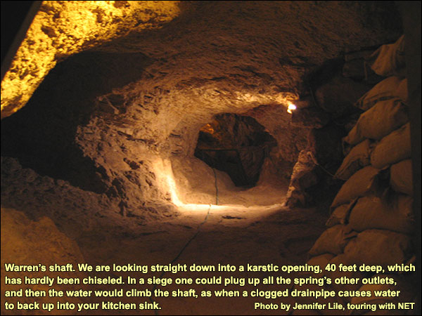
It is possible to draw water from this shaft. While searching for the lost ark and Solomon's treasures, Montague Parker's team in 1909-11 used it to clear mud from their dig below. The problem in antiquity would have been to divert water from the spring to the small cave at the shaft's bottom, which is higher than the spring. To do so in a time of siege, it would have sufficed to dig a connecting passage and plug up all alternatives. The water would then have climbed up the shaft (as when a drainpipe beneath your apartment is clogged and water from below backs up into your sink). This was strictly an emergency measure: when there was no siege, the spring would be allowed to flow to a more convenient place, as we shall see, and Warren's vertical shaft would deliberately be left high and dry. That is why there are no deposits of siltstone or travertine (tufa) in the cave at its bottom. Clearly, such an emergency system would not have sufficed for a large population, and the Siloam Tunnel (aka "Hezekiah's" Tunnel) superseded it. Before we discuss the Judahite water system further, let us continue with the one from the Middle Bronze Age. We climb the ladder and at once find, on our left, the opening into a fortified corridor 3700 years old. This corridor led out of the underground. Its parallel walls were 10 feet thick. Inside, on its stone floor, Reich and Shukron found sherds from the 18th and 17th centuries BC. (Reich and ShukronReich, Ronny and Eli Shukron. "Light at the End of the Tunnel," Biblical Archaeology Review, January/February 1999. , p. 30.) They found similar sherds between the bedrock and the lowest course of stones. This corridor, then, was built at the same time as the wall that Kenyon had discovered: wall, shaft, and corridor were made to fulfill a single plan.
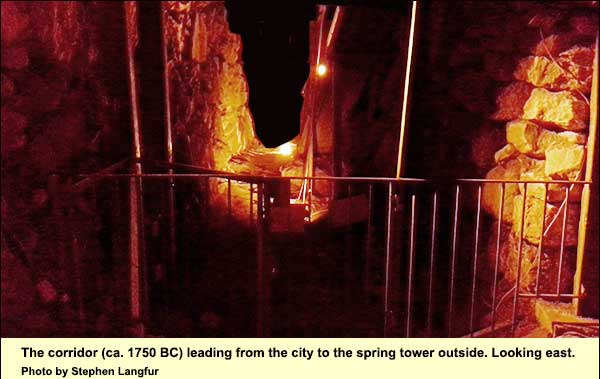
When you look at the photo of the corridor from outside (below), imagine that the walls on either side extend toward you as far as the tower that guards the spring, which begins a few yards behind the photographer. And now imagine the same double wall extending away from you, up the slope of the hill to the top. Although they have not yet excavated there, Reich and Shukron speculate that the fortification continued thus, forming the north wall of the city. As said, Kenyon's bit of wall seems minor when compared with this excavated portion.
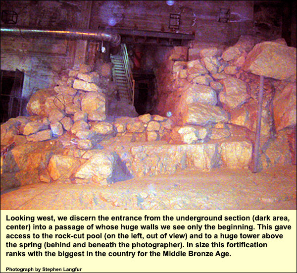
Nearby to the south, Reich and Shukron were astonished to discover a huge rectangular pool cut out of bedrock: 50 feet from east to west, 32 feet from north to south, and up to 46 feet high on its north end. It lines up perfectly with the MB fortification, and on this basis they date it to that time (1750-1650 BC). There must have been an opening in the south wall of the corridor above, from which people could walk onto a wooden platform over the pool and draw water. A wall on the pool's east side would have hidden the water drawers.
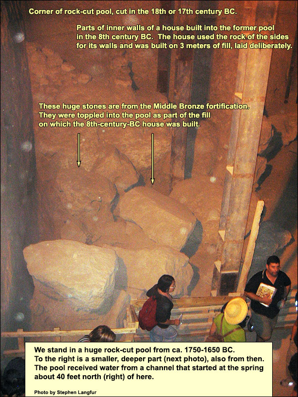
Why is the pool so big? Would the spring water ever have filled it? We recall that the output of the spring is extremely variable. On some days in some seasons, nowadays, it produces just 700 cubic meters, on others 4750. The MB inhabitants would not have wanted any to be lost. It received the spring water from a short tunnel numbered "III" by Father L. H. Vincent of the Parker expedition. Tunnel III got its water from Channel II, which in turn got its water from the spring itself. Here is a diagram with Vincent's numbers.
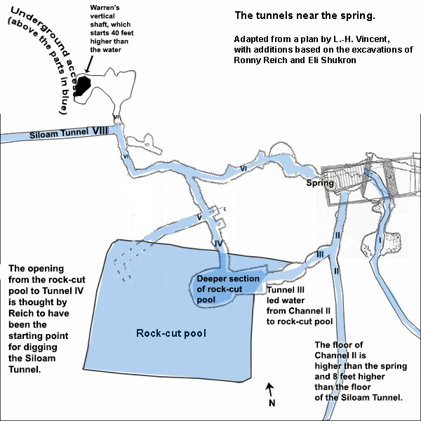
The floor of Channel II is several feet higher than the present spring and nearly 8 feet higher than the floor of the Siloam tunnel.Shanks, Hershel. “Will King Hezekiah Be Dislodged from His Tunnel?.” Biblical Archaeology Review, Sep/Oct 2013, 52–61, 73. http://members.bib-arch.org/publication.asp?PubID=BSBA&Volume=39&Issue=5&ArticleID=4 (accessed 9/28/2014) If we assume that the spring has remained at about the same level, not sinking like the one at Megiddo, we may suppose that the spring water, having no other egress, rose to the level of Channel II. Furthermore, only part of Channel II's water went into Tunnel III and thence to the rock-cut pool. Channel II continued southward - in its MB version for at least 190 meters south of the spring (see the map below). Many used to say that this section was intended to irrigate the fields of the Kidron, but ReichReich, Ronny. Excavatinued southward in Channel II - ng the City of David: where Jerusalem's history began. Israel Exploration Society, 2011, p. 161. casts doubt on that. (Among his arguments is this: The openings toward the Kidron are not human-made; they are karstic fissures, some of them too low to irrigate the valley, and there are no traces of further conduits branching from these fissures to distribute the water.) Reich speculates that Channel II led the water into a pool that would have been conveniently accessible as long as no siege was on. No one has yet searched for such a pool at or near the 190-meter point, partly because the valley is deeply silted here. At the 190-meter point, Channel II becomes a rock-hewn tunnel heading slightly southwest, to the area where the Hasmoneans later built the Pool of Siloam. There is no direct way of dating this southern section of Channel II, but it is thought to be an addition from the time of the Kingdom of Judah. The main use of Channel II was not to supply water to the rock-cut pool: that was an emergency system, requiring an arduous trek through what we today call Warren's shaft, and only a few people at a time could have access. No, its main use was in peacetime: to bring the water to the people at a place where many could draw it at once. In a time of siege, the Jerusalemites would have blocked the peacetime channel, so that the enemy would not get water, and all the water would then flow through Tunnel III to the rock-cut pool. This may explain the two levels in the latter: the smaller, deeper basin was for peacetime use by those living in the north of the city, while most of the water went south; the bigger, rectangular pool was meant to store water for the entire population in a time of siege.
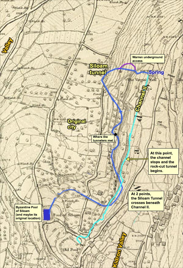
Channel II, or "the Canaanite tunnel" as it is called on the signs at the site, is dry today, and we can walk it for 120 meters. It is quite narrow in places - perhaps for easier plugging when under siege. Indeed, some think it was the tzinnor of 2 Samuel 5: 6-10. Some think, too, that the massive MB fortification at the spring was the "Fortress of Zion" on which the Jebusites relied (if so, it would have been about 700 years old when David reached the nearby Mount of Olives to attack). On the other hand, if the Large Stone Structure was already in place when David came - as I am persuaded it was - then it, combined with the Stepped Stone Structure, would have been the Fortress of Zion. A few meters into Channel II, on the right, is Tunnel III, which led part of the spring's water into the deeper section of the rock-cut pool.
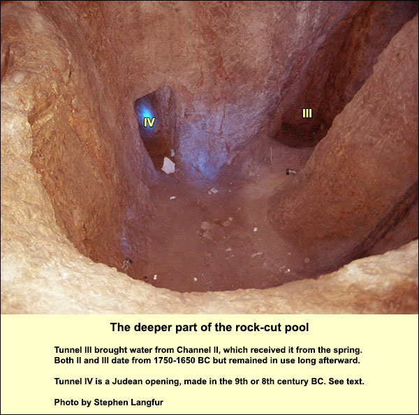
Looking into the deeper part of the rock-cut pool (photo above), we can see the entry of Tunnel III on the right. But notice also the doorlike opening on the left. This would have had no function for the MB Jerusalemites. According to Reich, it was an initial and temporary opening (Tunnel IV), made as the starting point for hewing the Siloam Tunnel (VIII), long known as "Hezekiah's Tunnel." The Siloam Tunnel was hewn by teams coming from north and south, and they met near the middle (see map above). ReichReich, Ronny, and Eli Shukron. "The Date of the Siloam Tunnel Reconsidered." Tel Aviv 38.2 (2011): 147-157. holds that the doorlike opening in the rock-cut pool was the first thing cut by the northern team. He bases this on the following thoughts. The Siloam Tunnel was dug after Channel II. The first 190 meters of Channel II belong to the MB system (the big fortifications incorporate it). Not only does the Siloam Tunnel provide more security, but its floor is almost 8 feet lower than that of Channel II. After the Siloam Tunnel was complete, Channel II would have been left high and dry. Now, the northern team could not have started at the spring itself, says Reich. If they had, the water - instead of climbing to the level of Channel II - would have flowed into their dig, rising against the rock walls and drowning them. They could not have stopped it by building a wall, for in that case they would have immured themselves. The only way, therefore, was to start at a point that was separated by bedrock from the spring; only after the rest of the tunnel was finished could they safely connect to it. (Reich thinks that the last connecting bit was part of Tunnel VI, whose chisel marks go toward the spring.) Where then can we find a feasible starting point for this northern crew? The doorlike opening in the deep section of the rock-cut pool is a good candidate. Furthermore, beside the doorlike opening is a surface that seems to have been prepared for an inscription, although there is none there. (Was it erased by a rival to the person whose name was on it?) If we take the doorlike opening as the starting point, we become immersed in a debate about the date: Was the Siloam Tunnel a project of Hezekiah, who reigned from 729 (but some say as late as 716) until 687 BC? When complete, as said, it deprived the (higher) Channel II of water, and the rock-cut pool went dry. Reich and Shukron discovered that someone then used the sides of the pool as the outer walls of a house. The pool's bottom was too low to suit this person, so before building the house, he dumped in a thick fill, including great stones that were toppled from the MB fortification (maybe they had already fallen). The deeper part of the rock-cut pool, including the presumed starting point for the northern team that dug the Siloam Tunnel, was surely filled as part of the same operation, but here the debris was removed by Parker around 1909-1911. The rest of the pool remained hidden until Reich and Shukron arrived in the late 1990s. They found 6.5 tons of pottery both above and under the floors of the house, including thousands of sherds that could indicate dating (rims, handles, and bases). Alon De Groot and Atalya Fadida have made a preliminary study.De Groot, Alon, and Atalya Fadida. "The Pottery Assemblage from the RockCut Pool near the Gihon Spring." Tel Aviv 38.2 (2011): 158-166. They are confident that the house was abandoned at the end of the 8th century BC, the time when the Assyrian king Sennacherib swept into the land to quell a revolt by Hezekiah, King of Judah. But when was the house first built? When did the builder dump in the fill, which buried Tunnel IV? If we assume with Reich that Tunnel IV was the starting point for digging the Siloam Tunnel, the starting date must have preceded the dumping of the fill. De Groot and Fadida, seconded by Reich and other experts, date the latest pottery from under the house's floor to the end of the 9th century BC. If the doorlike opening to Tunnel IV was indeed the starting point for digging the Siloam Tunnel, and if it was covered with fill around the end of the 9th century, then the tunnel must have been hewn then - or at the latest, "in the early part of the 8th century BCE,"Reich, Ronny, and Eli Shukron. "The Date of the Siloam Tunnel Reconsidered." Tel Aviv 38.2 (2011): 147-157. long before Hezekiah. Against this conclusion we may raise two points. 1. Among the kings of Judah, only Hezekiah is credited by the written sources with waterworks in Jerusalem. 2 Kings 20:20 - "Now the rest of Hezekiah's deeds, and all his might, and how he made the pool and the channel (t'alah) and brought the water to the city: are they not written in the annals of the kings of Judah?" 2 Chronicles 32:2-4 - "And when Hezekiah saw that Sennacherib had arrived and meant to make war on Jerusalem, he took counsel with his ministers and officers to block the water of the springs that were outside the city, and they helped him. Many joined together and plugged up all the springs, as well as the river flowing in the midst of the land, saying, "Why should the kings of Assyria come and find lots of water?" 2 Chronicles 32:30 - "And this was Hezekiah, he plugged the outflow of the water of the upper Gihon and led it straight down below westward to the City of David." Ben Sira 48:17-18 (Skehan translation, 1987, modified by Grossberg:Grossberg, Asher. "A New Perspective on the Southern Part of Channel II in the City of David." Israel Exploration Journal 63.2 (2013): 205-218. "Hezekiah strengthened his city by turning water into it. With bronze tools he cut through the rocks and sealed a mountain site for a reservoir. During his reign Sennacherib led an invasion..." The defender of Reich's redating might answer this objection as follows. Chronicles was written about three centuries after Hezekiah's reign, probably between 350 and 300 BC, when Jerusalem had been reduced in size more or less to its original eastern hill. It may be that the only waterworks known in person by the Chronicler were those of that small city. The same would have been true for Ben Sira, writing in the early 2nd century BC. Both of these sources had 2 Kings 20:20 in front of them, which they interpreted in terms of the small Jerusalem they knew. There they would have been familiar with the marvelous Siloam Tunnel, and since no other king had been awarded credit for it, they may have assumed that it was the work intended by the lost annals quoted in 2 Kings 20:20. This verse, however, need not have applied to the Siloam Tunnel. We need to remember that the city of Hezekiah had long been an expanded Jerusalem, including the Western Hill. Jerusalem's population had grown considerably in the course of the 9th and 8th centuries BC, perhaps because years of relative peace had transformed it into a thriving urban center. (Nadav Na'aman"When and How Did Jerusalem Become a Great City? The Rise of Jerusalem as Judah's Premier City in the Eighth-Seventh Centuries BCE." Bulletin of the American Schools of Oriental Research (2007): 21-56. has cogently opposed the notion that large numbers of refugees from the northern kingdom fled to Jerusalem after the conquest by Sargon II, swelling the city's population.) According to Avraham Faust,"On Jerusalem's expansion during the Iron Age II," in E. van der Steen et al., Exploring the Narrative: Jerusalem and Jordan in the Bronze and Iron Ages (2014): 256-285. the number of inhabitants in the expanded city probably exceeded 20,000. Those on the Western Hill would have needed convenient access to water. It is conceivable, therefore, that the pool and canal mentioned in 2 Kings 20:20 were somewhere to the west. David Amit has suggested (in a personal communication to Shimon Gibson) that the remains of an Iron II water conduit uncovered west of the Jaffa Gate might be part of such a system,Amit, D. 2009. Water Supply to the Upper City of Jerusalem during First and Second Temple Periods in Light of the Mamilla Excavations. In: Amit, D., Stiebel, G. and Peleg-Barkat, O., eds. New Studies in the Archaeology of Jerusalem and Its Region. Jerusalem, 3: 94–108 (Hebrew). and that it might have fed water to the Upper Pool of Isaiah 7:3 (perhaps the so-called "Pool of Hezekiah" in the Old City near the Jaffa Gate). 2. Carbon-14 datingFrumkin, Amos, Aryeh Shimron, and Jeff Rosenbaum, "Radiometric dating of the Siloam Tunnel, Jerusalem," Nature 425.6954 (2003): 169-171. of organic materials in the original floor plaster of the Siloam tunnel yielded dates of "about 700 BC or slightly earlier." However, the defender of Reich's redating might reply to this that given the margins of error in such tests, "slightly earlier" could mean several decades earlier. It is possible, then, that we shall have to stop saying "Hezekiah's Tunnel." But wait! In a recent article,Singer-Avitz, Lily. "The Date of the Pottery from the Rock-Cut Pool Near the Gihon Spring in the City of David, Jerusalem." Zeitschrift des Deutschen Palästina-Vereins 128.1 (2012): 10-14.Lily Singer-Avitz (one of the experts consulted by Reich) argues for a broader range of dates than that given by De Groot and Fadida. The fill beneath the house was a jumble. The builders dumped in debris that they got from the surroundings. Consequently, no strata could be distinguished. The only way to figure out the date of the dumping is to determine which sherds represent the latest pottery types. We can do that by comparing them to sherds that were found in well-stratified settings, if necessary in other cities, where we have an idea of the dates. Now, in the fill under the house floor, certain types were found that do not appear anywhere in strata from the 9th century BC, but that do appear in strata reflecting much of the 8th century in Lachish, the tell of Beersheba, and in Jerusalem itself. These types consisted of flat open bowls, folded rim bowls, and wheel-burnished bowls. De Groot and Fadida supposed that they represent a transitional phase, but Singer-Avitz points out that since there were no strata in the fill, one cannot talk about phases. The fact that a typical 9th-century sherd turned up next to a typical 8th-century one does not indicate a transition, rather just haphazard dumping. The pieces of flat open bowls etc. are simply the latest pottery found in the mix. This means that the fill could have been dumped, and Tunnel IV nullified, during the reign of Hezekiah. We get, then, the following picture. To dig the Siloam Tunnel, the northern crew started by opening Tunnel IV from the rock-cut pool, keeping 40 feet of bedrock between themselves and the spring in order not to be flooded. They then cut west (the left part of Tunnel VI), north, and west again. Here their work changed in style, becoming smooth and straight. After a long stretch they turned south, eventually meeting the other team. At this point the tunnel was complete except for about 20 meters between it and the spring. While the water still flowed into Channel II, they cut the right part of Tunnel VI, doing the last bit during one of the spring's off hours.The spring was once intermittent, as witnessed by Lewis Paton in Jerusalem in Bible times,1907, p. 170. The growth of Jerusalem in the 20th century led to urban leakage, hence an increase of water, with the result that it now flows constantly at varying rates. The connection between spring and tunnel was at last complete. The original starting point -Tunnel IV - lost its function, as did the rock-cut pool and Channel II. When we look at the diagram, a couple of things may bother us about the above account. Notice the nice straight Tunnel V branching off to the west from Tunnel IV and ending abruptly. Was this an early, abandoned attempt by the same workmen to cut the Siloam Tunnel? Leaving that question, notice that Tunnel VI is hewn in the same rough style throughout; it certainly looks like it was done in one piece - and by a different crew from the smooth team that did the Siloam Tunnel. Furthermore, if the Siloam hewers started at IV, why not cut westward from the end of IV, instead of (1) turning west and then north, in VI, toward Warren's vertical shaft and then (2) heading west again, suddenly changing the style of cutting, making the tunnel nice and straight? This question raises a new possibility, which I would put thus: Tunnels IV and VI were part of a system, whether in 800 BC or later, to lead the water from the spring to Warren's Shaft. After digging IV and part of VI as far as the shaft, the workers blocked IV and cut the rest of VI to the spring. Now the shaft and the spring were directly connected. In a time of siege, Channel II could be plugged at its start, leaving the water from the spring no recourse but to climb Warren's Shaft, from which it could be scooped out (again, as when a drain backs up and water gurgles from below into your kitchen sink). As long as there was no siege, Channel VI was plugged and Channel II was open. Such an emergency system, of course, is too limited for a large population. In the time of Hezekiah, therefore, before the Assyrians arrived, the dry vertical shaft could be used by workmen as an entry point for digging the nice, straight Siloam Tunnel, which starts right next to its bottom. This led to the Siloam Pool, to which many could have access from both the eastern and western hills. It was within the city wall. On either of the two scenarios just described - a later pottery dating for the fill in the rock-cut pool or the use of Warren's vertical shaft as entry point for digging the Siloam Tunnel - the name "Hezekiah's Tunnel" still applies. And so we can now describe the historical context. Starting in 735 BC, Assyria swept down upon the country and conquered the Kingdom of Israel. A second Assyrian conquest occurred in 720 under Sargon II, with devastating consequences. By that time many new Jerusalemites were living on the unfortified Western Hill. When Hezekiah planned his revolt (which began in 705), this hill got a massive wall, some of which can be seen today (by enlarging the picture on the right). Although the people on the Western Hill had water from cisterns that collected runoff, and perhaps a pool as well, they had no secure emergency system. If Warren's Shaft on the eastern hill was used for this, as I have speculated, it would not have sufficed for the city's population, which by then amounted to 20,000 or more.Faust, Avraham, "On Jerusalem's expansion during the Iron Age II," in E. van der Steen et al., Exploring the Narrative: Jerusalem and Jordan in the Bronze and Iron Ages (2014): 256-285.) The goal, therefore, was to lead the spring water to a safe and accessible place within the walls of the expanded city. Obviously, the position of the tunnel's outlet would not have made strategic sense if Jerusalem's wall had not encompassed the Western Hill, because in that case an enemy could attack from the latter as easily as from the Mt. of Olives. (See map below.) Since we are pretty sure that the Western Hill got its wall in the time of Hezekiah, this is another reason to ascribe the tunnel to him.
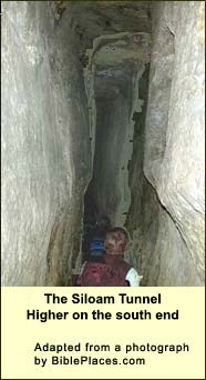
In 2 Kings 18:27, we read that after the Assyrians have taken Lachish, their envoy comes to Jerusalem and proclaims to its people that unless they surrender they are "doomed to eat their own dung and to drink their own urine." (More) Apparently he did not know about the new tunnel. The Assyrians failed to conquer Jerusalem. Hezekiah got off by paying a large tribute. Judea was devastated - essentially reduced to Jerusalem. Hezekiah's tunnel is one reason why the Assyrians failed. Suppose they had succeeded. They would have dealt with the Jerusalemites as they had with the northern tribes and the Judeans of the Shephelah, dispersing the surviving captives among their colonies. The Jerusalemites would probably have lost their national identity as the northerners did, assimilating to the new surroundings. There would then have been no one to preserve the texts that today make up the First Testament. (The Samaritans did not yet exist.) There would be, today, no Bible, no Judaism, Christianity, or Islam. This tunnel, therefore, has had a decisive role in making us who we are. A side note: The lowest part of the fill in the rock-cut pool contained about 180 bullaeClay seals for documents, often bearing an impression made by a ring that lacked Semitic letters but had images and decorations. The existence of such seals indicates that Jerusalem had a developed administrative system before the house was built. (Just to the south and east of the rock-cut pool, in layers corresponding to the upper parts of the fill beneath the house, Reich and Shukron found sherds from the late 8th century BC, as well as a few bullae with Hebrew writing on them.) Also, more than 10,000 fish bones turned up in the fill of the pool, mostly bream and mullet from the Mediterranean, but Nile perch too. We climb out of the rock-cut pool and find ourselves on a modern platform, facing the fortified corridor pictured earlier. We are now on the southern edge of the MB tower that guarded the spring. Almost a millennium after this tower was built, when David's son Adonijah had himself anointed king at a well to the south of the city called Ein Rogel, David countered by commanding that Solomon be placed on his royal mule and anointed "in Gihon." (Cf. Zechariah 9:9.Rejoice greatly, daughter of Zion!...Behold, your King comes to you! He is righteous, and having salvation; lowly, and riding on a donkey, even on a colt, the foal of a donkey.) Solomon probably had this old tower in front of him. How the Siloam (Hezekiah's, after all!) Tunnel was made From the fortified corridor, we descend into an inner section of the great MB Spring Tower, where we prepare to enter the Iron Age Siloam Tunnel. We shall need flashlights and footwear for walking in water, which will reach at a few places up to our thighs. The width of the tunnel remains a pretty consistent two feet, probably enough for Pooh. After feeling the rush of the spring, we wade through a short, roughly-hewn section. This was Tunnel VI. It connects the Siloam Tunnel to the spring. After a few meters, we see on the right, a few feet above the floor, the opening into the cave at the bottom of Warren's vertical shaft. Then we find ourselves in the long straight section. From the Siloam inscription, we know that there were two teams, one hewing from the south end and one from the north. Despite the big S-curve and the danger of passing too high or too low - and without the help of intervening shafts - they managed to meet near the middle. For the long straight stretch that we are now in, however, the tunnel does not head south, rather west, while the hill above gets ever higher. So far as I know, no one has been able to explain this odd westward beginning.
We can speculate. Let us suppose that the original plan was not for the two teams to meet. Rather, there were two separate projects. This becomes plausible when we examine how the southern team began. For when we near the south end, we shall see that the ceiling is much higher than elsewhere in the tunnel - about 15 feet. The reason was not because the southern team was following a karstic fissure, as I and many others used to think. Except for a few meters here and there, including the short stretch within which the two teams met, the natural fractures run crosswiseAmos Frumkin and Aryeh Shimron, “Tunnel Engineering in the Iron Age: Geoarchaeology of the Siloam Tunnel,” Journal of Archaeological Science 33 (2006). to the line of the tunnel, not with it or parallel to it. Why then is the ceiling so high on the south end? Ronny Reich thinks that the southern team began by hewing its floor precisely level with the floor of Channel II, the purpose being to connect to it. Channel II, on the original plan, would remain in use, but the new addition would bring its water to a less vulnerable point on the west side of the City of David (within the walls of the expanded city that included the Western Hill). The northern team was trying something else. They headed west, perhaps in the hope of intersecting with a large vertical fissure that was visible higher on the hill. The hope was that one of these two attempts would succeed, and then the other could be abandoned. But something happened that caused a change of plans. We do not know what. The teams decided to try to meet. The reasoning might have gone like this: Southern team: "We are making good progress toward intersecting the rock-hewn part of Channel II, but it's so close to the city's edge, so high up and vulnerable. Let us dig under it, therefore, to be at the same level as the northerners. Maybe we'll have enough time in this project to meet them. If not, we can always revert to the original plan and link up with Channel II in a jiffy: it will just be a matter of digging upward 2 feet at one of the points where we cross under it." Northern team: "No sign of the fissure we're looking for! They're pouring colored water like mad up there, but we're not seeing it drip. There is too much rock between us and the surface - 100 cubits! We can't hear tapping. We are lost. Let's turn to the left and back to where there isn't so much overburden." Here again is the map, and you can enlarge it to see the logic. The southern team crossed 2.5 meters beneath Channel II at two points, but the distance between their ceiling and the floor of II was only a couple of feet. The northern team wound back to an area of less overburden, where they could be guided by acoustic hammeringAmos Frumkin and Aryeh Shimron, “Tunnel Engineering in the Iron Age: Geoarchaeology of the Siloam Tunnel,” Journal of Archaeological Science 33 (2006). on the bedrock above them or by colored waterReich, Ronny. Excavating the City of David: where Jerusalem's history began. Israel Exploration Society, 2011, pp. 201-202 poured through fissures - or both. In the stretch where the teams were 19 meters apart, there is an exceptional fracture lengthwise in the rock, and each was able to hear the other's chisel. (A rare word in the Siloam Inscription probably refers to this fracture.) They therefore began searching for each other nearby, and this accounts for the many trials and corrections near the meeting point.
Note how well the change of plans would fit the situation of 705 BC, when the revolt against Assyria began. At first Hezekiah had no idea how much time he would have for securing the water supply. Sennacherib might pounce at once, and so he began with the two short-term plans mentioned above, hoping one of them would work. But then word arrived that Sennacherib was busy putting down other uprisings in the eastern part of his realm, and so it was decided (1) to keep a connection with Channel II in reserve as insurance but (2) to attempt the bigger and longer project. It was not until 701 BC that the Assyrian king arrived in the land, and by then the longer project had succeeded. We may wonder how both teams managed to preserve the same level, averting the risk that one group would pass above the other. Throughout the tunnel's 533 meters, the downward grade from north to south is only 30 centimeters. ReichReich, Ronny. Excavating the City of David: where Jerusalem's history began. Israel Exploration Society, 2011, p. 198 proposes an interesting solution. He notes that Channel I, stretching beside the city through the Kidron Valley, was built in such a way that its floor is precisely level with that of the Siloam Tunnel. The workers could have let a little water from it into either end as they dug: as long as the water stood without flowing, the level would be preserved. This may have been the entire purpose of Channel I.
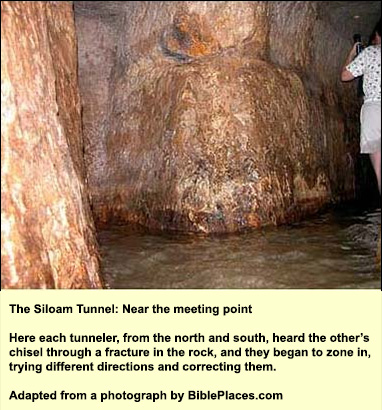
After we have sloshed through the tunnel for about 20 minutes, the passage begins to twist and turn, with occasional false starts and corrections. The hewers must have heard each other's chisels, as the Siloam Inscription indicates (see below). Until then a general direction had sufficed, but now they were honing in on each other.
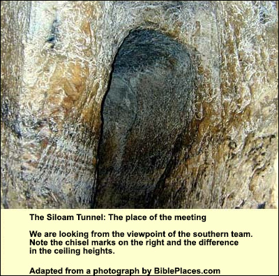
Amid the twists, one can make out a change in ceiling height, like a shallow step. Up to this point, the chisel marks in the sides were made in the direction of our movement. Beyond this point, their direction is against us. This then was the meeting point. The achievement was celebrated in an inscription, which was carved in the rock near the southern end, in the Hebrew letters of the time. A bather discovered it in 1880, when the land was under Ottoman rule. It is in the Istanbul Museum, but a copy appears in the original place on the tunnel wall (as well as in the Israel Museum). Its first part is missing (perhaps it had the name of Hezekiah and was erased by a successor):
[...when] (the tunnel) was finished. And this was the way in which it was cut through: - - while...] (were) still [...] axes, each man toward his fellow, and while there were still three cubits to be cut, [there was heard] the voice of a man calling to his fellow, for there was a crack [?] in the rock on the right [and on the left]. And when the tunnel was finished, the hewers hewed (the rock), each man toward his fellow, axe against axe; and the water flowed from the spring toward the pool for 1,200 cubits and the height of the rock above the head (s) of the hewers was 100 cubits. We emerge from the tunnel into a pool. This was the ByzantineThe Byzantine period – that is, the period of the Eastern Christian Roman Empire –may be dated from 330 AD, when Constantine re-named the city of Byzantium "Constantinople" and dedicated it to the God of the Christians. Its end, in this land, came in 638, when the Muslims took Jerusalem. Elsewhere it lasted much longer: Constantinople finally fell to the Turks in 1453. Pool of Siloam. Although we have no evidence for or against, it makes sense that the original pool of the Siloam Tunnel would have been here. The tunnel, after all, comes out at this point, which was protected by the wall of the expanded city.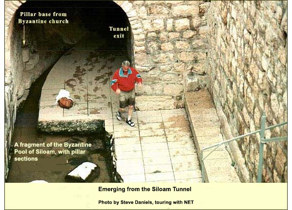
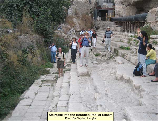
This Byzantine pool's shape is unknown, but certainly it was bigger than what we see. It was not, however, the Pool of Siloam of which we read in the Gospel of John. To it we now turn. The Pool of Siloam as Jesus knew it In the spring of 2004, Jerusalem’s water company decided to replace an old concrete sewage main that ran on a line dividing the south cliff of early Jerusalem from a beautiful green orchard with figs and pomegranates, which is about where the "King’s Garden" of Nehemiah 3:15 would have been.. A bulldozer, while digging a channel for the new sewer main, exposed a couple of stone steps. Thus began the discovery of the Pool of Siloam as Jesus knew it. For the story in full, see Reich. Reich, Ronny. Excavating the City of David: where Jerusalem's history began. Israel Exploration Society, 2011, p. 225ff. He and Shukron uncovered five steps and a landing, then another such grouping below it, and then yet another. Above there was just the cliff, so they understood that the steps could only have led downward. It was then that they suspected that they had found a pool. Reich remembered that earlier archaeologists, Bliss and Dickie, had dug here. Looking up their reports, he saw that they too had discovered steps – but theirs were perpendicular to the ones just found. He and Shukron returned to the spot and rediscovered these, unearthing the southeast corner:
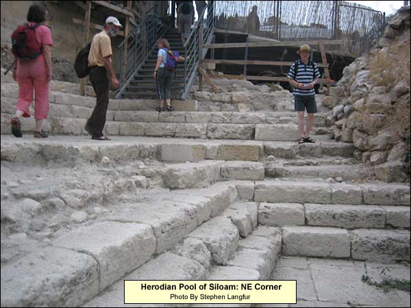
At a couple of places, as you can see in the photo above, the stone steps were gone, revealing earlier steps built of gray cement and rubble with a covering of plaster. Reich remembered the steps of numerous miqva’ot, Jewish ritual baths, from the time of the Second Temple. A metal detector was brought, and in the gray steps they found coins – all from the mid-1st century BC, hence Hasmonean or Herodian. We do not yet know the full dimensions or depth of the pool - or how many more sets of steps may turn up. A crucial section of the unexcavated part belongs to the Greek Orthodox Church, which has not yet permitted a dig. By the time of Jesus' visits to Jerusalem, the Siloam system may no longer have been the city's chief source of water. The Pools of Bethesda were in place (the steps are similar there). Herod had brought more water from elsewhere. Yet the grandeur testifies to Siloam's continuing importance. Below is a view to the northwest. Notice how the pool has silted up on the left. Silt must already have covered it in the Byzantine period, for if any of the pool had been exposed, the Byzantine Empress Eudocia would surely have chosen to build her Pool of Siloam (with church) right here. Seeing no trace, she must have assumed that it would have been in the logical place: at the exit of the Siloam Tunnel (where, indeed, the First Testament pool may have been).
On the northeast, a few yards to the right of the people in the photo above, is a much narrower pool that fed the water from the Siloam Tunnel into this one.
If we walk northwest, we shall find - beside what was a plaza and colonnade - the start of a beautifully paved, stepped Herodian street (with irregular steps like those at the temple itself) that led from the Pool of Siloam north to the temple. The street was much wider here than what we can see: Only a narrow strip on its eastern side is now exposed. The connection between pool and temple suggests that many, even most, of the Jewish pilgrims 2000 years ago would have done their ritual immersion in the pool before ascending to the temple. It didn't matter if you got there sweaty: the point was to be cleansed of impurities as defined by Jewish law, such as those originating in contact with a corpse, semen, or menstrual blood. Impurity, we should note, was quite distinct from sin. We may relate this distinction to John 9. On seeing a man who had been blind from birth, the disciples asked Jesus whose sin had caused the blindness. Jesus answered that no sin had caused it, rather it was so that the work of God might be displayed in his life. He then took some soil, turned it to mud with his saliva, and smeared it on the blind man's eyes, telling him to go wash in the Pool of Siloam.
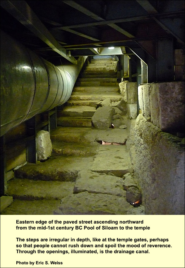
A few steps to the west, beneath an unexcavated part of the same paved road, begins the canal that drained waste for 650 meters from the temple area down to the Kidron Valley. Today you can ascend through this canal. The paving stones of the street are above your head in the southern part, stone vaulting in the northern.
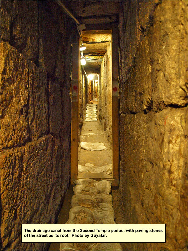
You need not go the whole distance, for there is an outlet after about ten minutes into a new excavation area called Givati. But if you do go the distance, you can pause in some First Temple cisterns on the way, complete with the ancient waterproof plaster. Early Jerusalem, we recall, was not wholly dependent on its spring for water. It had watersheds on the west, north, and east from which it could receive runoff - as these cisterns attest. You can also see the foundation stones of the Western Wall resting on bedrock. The exit is near the southwest corner of the temple platform.
In the drainage canal the archaeologists found many whole cooking pots. One hardly ever finds whole pots, except in tombs. But we know from Josephus (War VI, 9, 4) that when the Romans were about to conquer the city, many Jews hid in the sewers, hoping to live there undetected until the Romans left.
[T]he entire nation was now shut up by fate as in prison, and the Roman army encompassed the city when it was crowded with inhabitants. Accordingly, the multitude of those that therein perished exceeded all the destructions that either men or God ever brought upon the world; for, to speak only of what was publicly known, the Romans slew some of them, some they carried captives, and others they made a search for under ground, and when they found where they were, they broke up the ground and slew all they met with. There were also found slain there above two thousand persons, partly by their own hands, and partly by one another, but chiefly destroyed by the famine; but then the ill savor of the dead bodies was most offensive to those that lighted upon them, insomuch that some were obliged to get away immediately, while others were so greedy of gain, that they would go in among the dead bodies that lay on heaps, and tread upon them; for a great deal of treasure was found in these caverns, and the hope of gain made every way of getting it to be esteemed lawful.
The bodies have disappeared. Perhaps the Romans dragged them out and burned them. But occasionally, while one walks, one can see places where the pavement was opened - apparently by the Romans. In the canal there was also a Roman sword and its leather scabbard. And the pots.
For claustrophobes the drainage canal is a challenge. The happy alternative is to leave the Siloam Pool through its eastern gate and ascend the spine of early Jerusalem. To this we now go.
{mospagebreak title=Spine of the City} Who shall ascend the hill of the Lord? After we issue forth from the Siloam Tunnel, our bus can receive us near the Pool of Siloam, but if we prefer, we can make the steep climb up the spine of the ancient city, or in the words of Psalm 24, we can "ascend the hill of Yahweh." (There is also a shuttle service after 11 a.m. to the top of the hill.) On scaling the edge, we stop for a look at the meeting of the valleys: the Kidron, the Tyropoeon and the Valley of the Sons of Hinnom, which join and cut from here through the wilderness to the Dead Sea. Covering most of the Second Testament Pool of Siloam is a rich green area. We saw its edge at the pool, but now we see all. Here, probably, was the royal garden mentioned in Nehemiah 3:15, where Shelah is Siloam (shiloach in Hebrew): Shallun the son of Colhozeh, the ruler of the district of Mizpah repaired the spring gate. He built it, and covered it, and set up its doors, its bolts, and its bars, and the wall of the pool of Shelah by the king’s garden, even to the stairs that go down from the city of David. We would have liked Shallun's stairs on ascending a minute ago! Continuing upward, we soon find a wire gate on our right. We enter and head a bit further east until we see, to the northwest, the openings of two large rock-cut horizontal shafts (there is a third behind them). They may have once been even longer, but already in antiquity this area became the focus of intensive quarrying - perhaps for the stone to build the Byzantine Pool of Siloam and its church. The marks of quarrying suggest the original lengths.
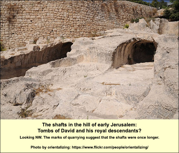
Egyptologist Raymond Weill, who studied the shafts and the area around them in the early 20th century, proposed that here were the tombs of David and his royal successors. David, we know, "slept with his fathers and was buried in the city of David" (1 Kings 2:10). The same formula is repeated for Solomon, Rehoboam, Asa, Jehoshaphat, Ahaziah, Joash, Amaziah, Azariah (2 Kings 15:7, despite 2 Chronicles 26:3), Jotham, and Ahaz. Only to the kings does the Bible attribute burial within the city. (For the later tradition of David's Tomb on Mt. Zion, see here.)
Furthermore, the next verse in Nehemiah is this (3:16):
After him, Nehemiah the son of Azbuk, the ruler of half the district of Beth Zur, made repairs to the place opposite the tombs of David, and to the pool that was made, and to the house of the mighty men.
So the author and first audience of Nehemiah 3 understood the tombs to be not far from the steps going down, where we ascended. It seems we are in the area, which was that of Weill's investigation. In the early 20th century, furthermore, the hill was hardly inhabited; if there had been any other likely places into which so many kings could have been gathered, you would think he would have encountered them. On the other hand, we have no fancy sarcophagus or inscriptions from that time, so we cannot know.
Archaeologists respond to Weill's conviction about these shafts with a kind of pooh-poohing. Such a find, after all, would be too good to be true. But they possess no strong arguments contra. True, the tombs don't look like Judahite tombs we know, but the latter date from two hundred years later. True, a bit of the grayish cement that is typical of the Hasmoneans was found on a bit of the wall, along with a typical Hasmonean lamp-niche, but by that time the memory may have been lost and the tombs may have been re-used. True, there are signs of a synagogue in the vicinity, including a ritual bath and a long dedicatory inscription in GreekIt gives credit to one Theodotus, priest and ruler of the synagogue, for building a synagogue and the associated chambers (evidently a large complex). (found by Weill), so indeed the shafts could have served as basements to it, but that says nothing about their original use. True, the shafts seem rather simple for royalty, but simple likewise are other known royal tombs from the Middle Bronze and Late Bronze ages in the ancient Near East, as Jeffrey Zorn“Is T1 David’s Tomb?.” Biblical Archaeology Review, Nov/Dec 2012, 44-52, 78. http://members.bib-arch.org/publication.asp?PubID=BSBA&Volume=38&Issue=6&ArticleID=6 (accessed 9/29/2014) points out in an essay that is my source for much on this page.
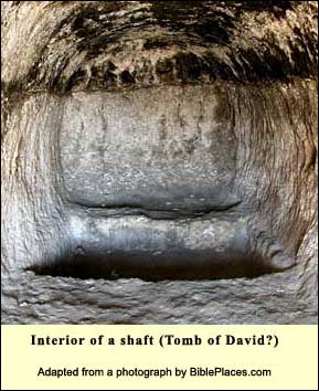
Now let us turn to the positive features (though many could be later modifications). The shaft on the west, which is currently the more impressive, is about 54 feet long, 8 wide, and 6 high. (To judge from the quarrying marks in front, both shafts were once much longer - you could call them tunnels.) At a certain phase people lowered the floor of the first 32 feet, increasing the height there to 12 feet. They then cut a doorway and steps to enable access to this lower portion. Long horizontal grooves on both sides, at the height of the original floor, may have served to insert a platform, so that the result was two floors. In the upper section, in the back, there is a rock-cut depression, 6 feet by 4, which could have held a sarcophagus or a body together with grave offerings. It is the shadowy area in the photo on the left; its long side stretches away from us. Weill found two low masonry walls with a blackish coating that turned the depression - he thinks at the time of the Second Temple - into a basin; he also dates the blackish covering on the ceiling to that time.
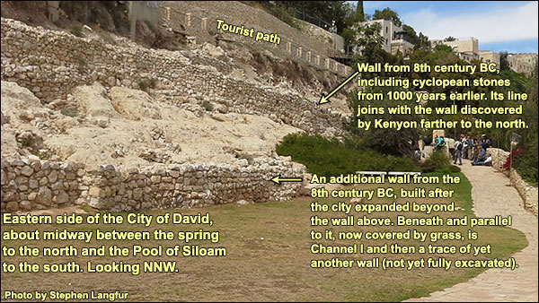
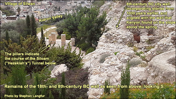
We continue to ply our way up the mountain toward the site of the ancient temple. If the going is hard, let us remember what we are ascending. There was a time when most Jerusalemites lived on this hill, which they would mount in procession toward the temple. We may imagine them singing, as they climbed, Psalm 24.
{mospagebreak title=Logistics} Logistics for visiting the first Jerusalem and the City of David The "City of David Visitors Center" (which has restrooms) controls the site. Telephone: (02)6262341 or *6033. Open in winter from Sunday through Thursday 08:00 -17:00, Friday and holiday eves, 08:00 - 13:00. Open in summer from Sunday through Thursday 08:00 - 19:00, Friday and holiday eves, 08:00 - 15:00. The Pool of Siloam has different hours, which should be checked by phone. The whole site is closed on Sabbaths and Jewish holidays. Leave enough time to complete the tour (e.g. the Siloam Tunnel). For the Siloam Tunnel, 60 cm. wide, be prepared to walk fifty minutes in water, which in a few places can reach your pockets (depending where they are). You will need footwear that won't slip off in the current. A flashlight (candles not permitted!) is necessary. The Canaanite tunnel is dry and shorter, but also narrower in places.There are restrooms at the main entrance, near the end of the Canaanite Tunnel, and at the Second Temple Pool of Siloam. Near the ones at the main entrance are lockers where you can leave clothes and gear before going through the tunnel, but you can also simply carry them in a high-enough backpack.
Since this hill is a residential neighborhood, it can be visited apart from the opening hours. The main entrance is open, and the area of the Stepped Stone Structure is accessible, as well as a spot for an overview. The entrances to the Large Stone Structure, to Warren's Shaft and to the tunnels will be locked. One should be aware, too, that the neighborhood is inhabited both by Palestinian Arabs and Israeli Jews. There are tensions between the two groups deriving not just from the general conflict but also from specific disputes here over land and housing.