Megiddo
{mospagebreak title=Importance}
Why was Megiddo important?
In order to control the ancient world, one had to control Megiddo. Or in the words of Pharaoh Thutmose III (15th century BC), "The capture of Megiddo is the capture of a thousand cities." Why was it so important?
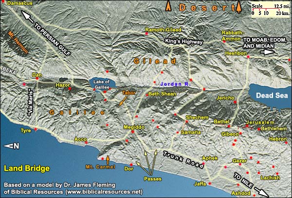
Answer: This land was a kind of bridge between the great civilizations of Egypt and Mesopotamia, for the simple reason that here the traveler had water to drink. The bridge was about 75 miles wide, extending a few miles east of today's Amman in Jordan. That was the limit of the arable land. Further east lay 400 miles of desert. Travelers followed, therefore, the Fertile Crescent, which narrowed in this land.
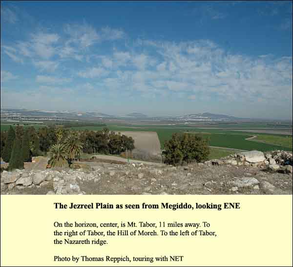
But the land bridge was interrupted by a mountain range. It stretches through the center of the country and bends northwest, thrusting into the sea as Mt. Carmel. Travelers avoided climbing mountains if they could. Any pass through the range was therefore crucial. What's more, the north includes a large flat area called the Jezreel Plain. A pass through the mountain that reached this plain would have international importance. There were three such, but people generally preferred the one that reaches the Plain at Megiddo.
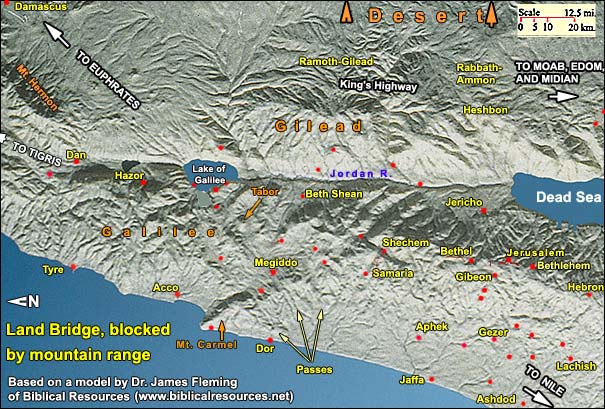
At times when no major empire promoted an alternative trade route, the Megiddo pass was preferred. There were several reasons:
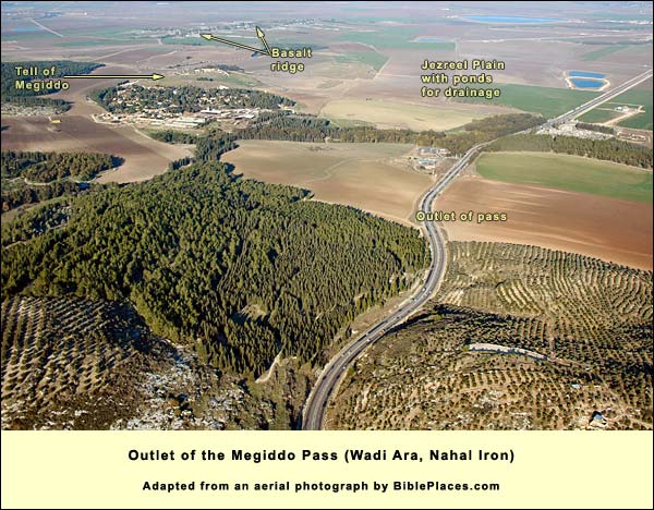
1. Winter posed a problem in the Jezreel Plain. Its corners tilt upward (for example, below the edge of Mt. Carmel in the photo on the right), and there is only the narrow brook Kishon to drain it. Unless special measures are taken (e.g., the reservoirs and fish ponds one sees today) much of the plain becomes mud in the rainy season. But there happens to be a slight basalt ridge stretching across the plain toward Megiddo, starting from a volcanic area near the Hill of Moreh. (Moshav Ha-Yogev and Tell Adashim sit on the ridge today.) By keeping to this rise in the winter, the ancient traveler could stay for the most part above the mud. Anyone who has sampled the mud of the Holy Land knows what this means! The Canaanite general, Sisera, for example, sampled it with his 900 iron chariots: he learned how significant the mud of this plain can be. (Interpreting Judges 4 and 5.)
2. Megiddo was more important than the cities on the ends of the other passes, because it was more central. The Jezreel Plain has the form of an isosceles triangle with Mt. Tabor at the apex. Megiddo sits near the middle of the base. It functioned as a hub. Through it passed not only the Great Trunk Road between Egypt and Mesopotamia, but also branches to (1) Acco and Phoenicia, Beth Shean and the Kings HighwayThe "King's Highway" (Numbers 21:22) was the second major trunk road. It stretched from Arabia Felix (Yemen today, then rich in perfumes and spices) through Transjordan to the great oasis at Damascus. Upon this stretch fell the last rains from the Mediterranean. East of the highway lay 400 miles of desert., as well as the cities of the central range (such as Samaria, Shechem, Jerusalem and Hebron).
3. To continue with the reasons for the importance of this city: the narrow part of the pass to Megiddo is the shortest of the three.
4. Finally, Megiddo was famous for its springs ("the waters of Megiddo" in Judges 5:19).
No wonder, then that the capture of Megiddo was "the capture of a thousand cities." The campaign of Thutmosis III, around 1469 BC, was the first of many battles to focus on Megiddo and its adjoining plain.
{mospagebreak title=Archaeology/History}
Archaeology and History at Megiddo
1. The Early Bronze Age, 3300 - 2000 BC
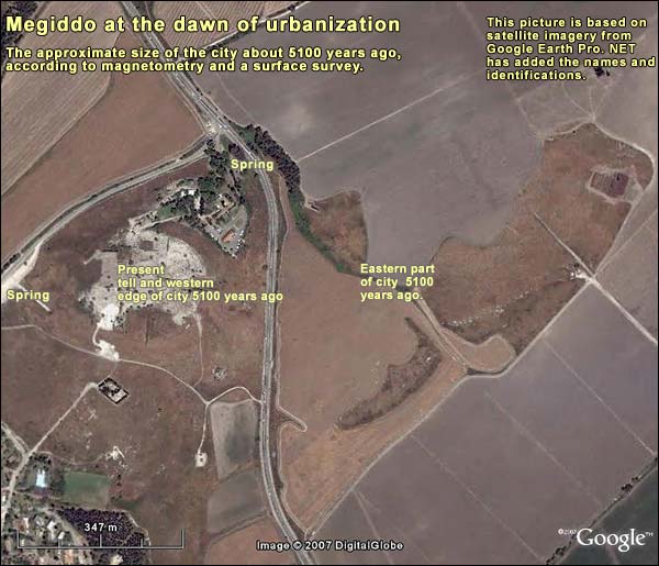
Around 3100 BC, when cities first began to develop all over the ancient world, Megiddo was huge. It included the mound we see today, but magnetometry and a surface survey have shown that it extended for another 800 meters to the east. Its area was about 50 hectares (125 acres). By all accounts so far, this was the largest urban center at the time in the Levant.The lands of the Eastern Mediterranean, from Turkey to Egypt Its position on the international trade route probably did not play a major role then (there may not have been much interaction between Egypt and Mesopotamia when the donkey was technology's cutting edge). The city occupied, however, a dominant position on the routes of local trade (and there is evidence of commerce with Egypt). Megiddo was the midpoint on the base of the isosceles triangle that formed the Jezreel Plain. There were dozens of settlements nearby for which it served as a metropolitan center. In fact, during periods of general decline, when other cities shrank in size and prosperity, Megiddo was the exception. Additional factors were its abundant springs and its large agricultural hinterland. (Megiddo IIIIsrael Finkelstein, David Ussishkin and Baruch Halpern, eds., Megiddo III: The 1992-1996 Seasons, Tel Aviv, 2000 pp. 577-84, and Megiddo IVIsrael Finkelstein, David Ussishkin and Baruch Halpern, eds., Megiddo IV: The 1998- 2002 Seasons, Tel Aviv, 2006, pp. 843-47.)
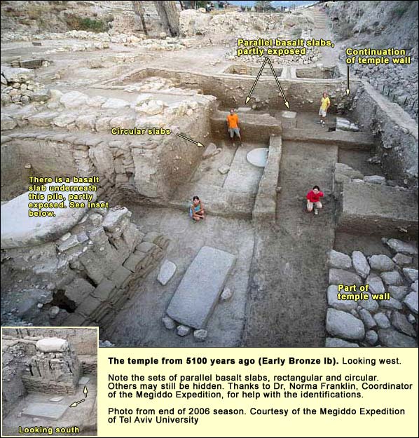
The size of this 5100-year-old city is reflected in its temple, "the most monumental Early Bronze I structure known in the Levant, if not the entire Ancient Near East" (Megiddo expedition website). In its corridors the diggers found a huge quantity of animal bones (mainly of sheep and goats, none of humans); they lay about 25 centimeters (10 inches) deep "across a broad horizontal span of at least 45 metres" Baruch Halpern,Baruch Halpern, "Centre and Sentry: Megiddo's Role in Transit, Administration and Trade," in Israel Finkelstein, David Ussishkin and Baruch Halpern, eds., Megiddo III: The 1992-1996 Seasons, Tel Aviv, 2000 p. 536. To judge from the size of this sacrificial accumulation, it seems that the temple served not only the residents of the city itself, but also those of the towns in its hinterland. The temple's full dimensions have not yet been determined, but the 2006 dig revealed six beautifully cut basalt stones that belonged to the central hall: two rectangles, two circular stones, and again two rectangles. There may be more.
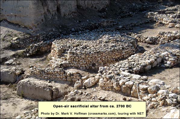
At the start of the 3d millennium BC, the city shrank back within the scope of the present upper mound. Around 2700 BC, in the area of the former great temple, the inhabitants built an open-air sacrificial altar that still stands today. It was uncovered by the American expedition that dug here from 1925 until 1939. Constructed of unhewn stones, and with a staircase ascending it from the east, it is 8 meters across and 1.5 meters high. Walls surrounded it in the form of a square. Between the round altar and the walls the expedition found large quantities of animal bones and potsherds. The altar continued in use through most of the 3d millennium. Temples went up around it.
2. The Middle Bronze Age, 2000 - 1550 BC
In this period Megiddo went through expansions and contractions, always including the tellIn general, before the Roman period, a city needed a hill for defense, with a spring nearby. Certain proportions had to be right: the hill had to be small enough so that the population supplied by the spring would suffice to produce enough soldiers to defend a wall surrounding the hill. You needed enough good agricultural land to feed that population. (You also needed peasants in nearby villages to work the land – about ten for every aristocrat in the city.) If you wanted to engage in commerce, you had to be near a decent road. Only certain hills fulfilled these requirements, and therefore people kept building on them. That is why we find layer after layer on some few hills, called tells, while others remained unsettled that we see today (the upper mound) and sometimes, to its north, a lower one. (The HQ of the American expedition, now the Visitors' Center, occupies a small part of the latter.) In order to form the lower mound, an earthen embankment was built. Perhaps it was topped by a wall. The upper mound was extended about 10 meters northward by a wall over which earth was heaped, forming a glacisAn artificial slope, meant to keep attackers from entering a city.. This type of fortification was typical for cities in the Middle Bronze Age, starting in the 18th century BC. It gave the tells their characteristic shape of an upside-down cupcake.
The horse was domesticated in the Ancient Near East around 2000 BC (although no one is sure, and it may have been earlier). With horses coupled to wagons and chariots, commerce and war could begin between Egypt and Mesopotamia. Canaan became the "land bridge" between the two, though interrupted by a mountain range. It stands to reason that Megiddo would have benefited from its prime position on the best pass through that barrier. So far, however, nothing has been found on the site attesting to long-range commerce or warfare during the Middle Bronze Age.
In 1650 BC, having mastered horse-and-chariot warfare, the HyksosIn the 18th and 17th centuries BC, Canaanites settled massively in the eastern Nile delta, eventually seizing dominion over lower Egypt. The Egyptians called them "Hyksos" ("foreign rulers") – and managed to throw them out after a century. The ceramic remains, scarabs and weapons at the Hyksos capital of Avaris (Biblical Zoan) are very similar to those found in contemporary Canaanite sites. took over Egypt. A century later Pharaoh Ahmose reunited Egypt and expelled them.
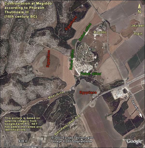
3. The Late Bronze Age, 1550 - 1200 BC For the next 80 years or so, Egypt seems to have made only sporadic raids into Canaan. However, In the time of Pharaoh Thutmosis III (1479 - 1425 BC), a new era opened. Some 119 Canaanite city-states banded together to keep Egypt behind the mountain barrier that interrupts the land bridge. The center of the revolt, therefore, was Megiddo, which sat near the principal pass. By getting through and capturing Megiddo, Thutmosis could begin establishing firm Egyptian dominance over Canaan. He celebrated his first victory in a detailed account, engraved on the wall of the Temple to Amun in Karnak. Thus the first battle in history to be presented in detail is centered on the site of Armageddon! During the march north through the coastal plain, at a town called Yahma, Thutmosis and his generals had a council. The generals expressed their fear of traveling by the narrow pass that led straight to Megiddo. They proposed to take one of the alternative passes. "Will not horse come behind horse and man behind man likewise? Shall our advance-guard be fighting while our rear-guard is yet standing yonder in Aruna not having fought?" (Aruna was the town on the western end just before the pass gets narrow.) A few lines later comes the sentence: "Then went messengers concerning this design which they had uttered..." It may be that the "messengers" were scouts, who discovered that the enemy had split its forces, anticipating an Egyptian advance through the alternative passes as the generals had proposed. Thutmosis replied to the proposal as follows:
"I swear, as Re loves me, as my father Amon, favors me, as my nostrils are rejuvenated with satisfying life, my majesty will proceed upon this road of Aruna. Let him who will among you, go upon those roads ye have mentioned, and let him who will among you, come in the following of my majesty. Shall they think among those enemies whom Re detests: 'Does his majesty proceed upon another road? He begins to be fearful of us,' so will they think."
The generals, of course, fall into line, and Thutmosis leads his army through the pass, going first. He keeps the main bulk of his force at Aruna, until he has secured the outlet of the pass. This he manages somehow to do. Then he brings the main force through. The inscription is explicit about the battle positions:
The southern wing of this army of his majesty was on a hill south of the brook of Kina, the northern wing was at the northwest of Megiddo, while his majesty was in their center, with Amon as the protection of his members, the valor of his limbs.
RaineyAnson F. Rainey and R. Steven Notley , The Sacred Bridge, Jerusalem, Carta, 2006 (p. 67) has suggested the tactic behind this choice of positions. In those days, he writes, chariots were not built for maneuverability, that is, for frontally attacking lines of foot soldiers, but functioned rather as mobile firing platforms. The rebel Canaanite forces probably had an advantage in chariotry. Thutmosis chose therefore to focus the engagement in the narrow, curving valley between Megiddo and the hill to its west, where the the chariots could not maneuver around his flanks.
Then his majesty prevailed against them at the head of his army, and when they saw his majesty prevailing against them they fled headlong to Megiddo in fear, abandoning their horses and their chariots of gold and silver. The people hauled them up, pulling them by their clothing, into this city; the people of this city having closed it against them and lowered clothing to pull them up into this city. Now, if only the army of his majesty had not given their heart to plundering the things of the enemy, they would have captured Megiddo at this moment...
In fact, as we learn from another inscription, the siege lasted seven months! We may well wonder where the besieged could have gotten water for seven months. Was an underground water system already in place, so that they had access to one of the springs from inside the city? And why didn't the rebel allies - more than a hundred towns in number - launch an attack to relieve the siege?
We do not yet know the answers. The result, in any case, was that Egypt established a firm hold on the land bridge east of the mountain barrier. As a precautionary measure, it did not allow Canaanite cities to have walls. No walls have yet been found from this time at Megiddo or elsewhere. The embankment of the upper mound remained in place. The lower mound ceased to be part of the city after the conquest of Thutmosis, but its history was not over.
In the Amarna lettersIn 1887 a peasant woman at el-Amarna in Egypt discovered 379 clay tablets in the ruins of the Pharaoh Ikhnaton's palace. These included letters in Akkadian from princes of city-states in the land of the Bible, such as Megiddo and Jerusalem, as well as some from Babylonia and Assyria. Written in the 14th century BC, they convey an impression of unstable conditions in the land at that time., the king of Late Bronze Megiddo, Biridiya, asks the Pharaoh of that time, Amenhotep III, to send troops to help him against a local chieftain named Labayu, whose power base seems to be in the area of Shechem. Labayu is in league with a group of perennial outsiders called apiru or hapiru (a term that is tantalizingly close to "Hebrew," though no connection has ever been proved). It is interesting that a hillbilly strongman like Labayu (and later his sons) could cast terror among the cities of the plains. Egypt's hold had clearly weakened. Biridiya of Megiddo asserts in a letter that he is protecting the walls of the city, but as said above, no walls have been found. Perhaps he meant the embankment (glacis) of the upper mound, which was still used at this time.
In the 13th century BC, Megiddo got a new lease on life. Both mounds were again occupied. The lower mound included a large public building, but the lower city gate has not yet been located. The gate to the upper mound, however, was discovered preserved to an unusual height. Here is a frontal view:
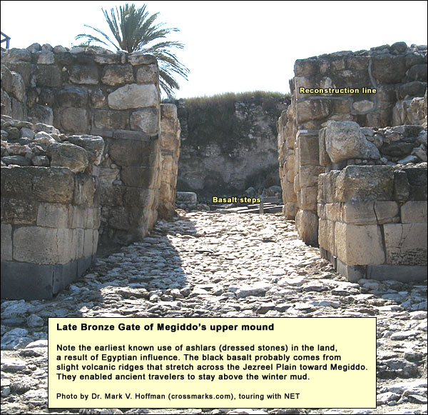
There was, as said, no wall at the time. The gate was built right into the Middle Bronze embankment.
Some of the finds from this last Bronze Age city can no longer be seen on the site. The international connections are indicated by a statue base of Pharaoh Rameses III, as well as a 13th century seal from the Hittite Empire in Asia Minor. Just inside the gate pictured above, to its northwest, was a palace. One floor was paved with sea shells. In a subterranean chamber, the royal inhabitants hid a treasure of 382 ivories. One of them shows a Hittite king. A cartouche of Pharaoh Ramses III appears on a pen case. Other ivories were intended for a lady's dressing table. These include combs, bowls probably for cosmetics, handles for mirrors and fans (or fly swatters), a casket ornately carved from a single piece, and elaborate game boards. (DaviesGraham I. Davies, Megiddo, Cambridge: Lutterworth, 1986, p. 65.)
There were other large public buildings east of the gate, and there was a temple designed like a tower, similar to one from Middle Bronze Shechem. Remarkably, however, most of the upper mound was unoccupied. The few who lived on it were the privileged classes and their servants. "Megiddo," write the current excavators, "seems to provide a good example of the nature of the major city-states in Canaan during the later part of the Late Bronze Age. It served the king and the elite, who ruled over the rural population of the countryside" (Megiddo IIIIsrael Finkelstein, David Ussishkin and Baruch Halpern, eds., Megiddo III: The 1992-1996 Seasons, Tel Aviv, 2000, p. 593.) Research, they continue, has revealed over 30 small sites nearby that were probably subordinate to Megiddo.
This final, sumptuous Late Bronze Megiddo was destroyed in the mid-12th century BC, at a time of famine and great upheaval throughout the eastern Mediterranean basin. Two of the area's three great civilizations collapsed: Mycenean Greece and the Hittite Empire. The turbulence reached the shores of Egypt and almost brought it down as well. Great masses of people were on the move, including Israelites in the wilderness and the Philistines. Nearly every major city north of Egypt fell before these hordes. Under pressure, Egypt withdrew from Canaan. Except for a few brief forays, it would stay out for centuries. Local leaders would get a chance to assert themselves – e.g., the Philistines, Saul, David, Solomon, Ahab and Jeroboam II. Much of Biblical history takes place in the rare interval when no great empire is dominating the land from Egypt, Asia Minor or Mesopotamia.
Iron I, 1200 - 1000 BC
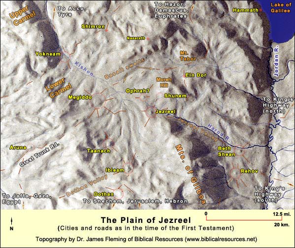
To the period of the great upheaval, which lasted into the Iron Age, we should date the battle of Deborah and Barak against the Canaanites "at Taanach by the waters of Megiddo" (Judges 5:19). Before this battle, a belt of Canaanite city-states controlled the Jezreel plain. (These cities, in a southerly curve from west to east, were Yokneam, Megiddo, Taanach, Ibleam, and Beth Shean; all may be seen in the map below.) The Israelite tribes were cut off from each other. ("Travelers had to take byways." Judges 5:6.) Deborah's victory loosened the Canaanite hold.
A generation or so after Deborah's victory, however, came the Midianites, who crossed the Jordan on camels and raided the Israelite harvests in the Jezreel Plain year after year. In response to this new crisis, Yahweh granted charismatic power to Gideon. Starting from the spring of Harod at the foot of Mt. Gilboa, Gideon and his picked men defeated the Midianites, who were encamped at The Hill of Moreh. (Judges 7)
After Egypt's withdrawal (ca. 1150 BC), those trade relationships that survived continued to focus at Megiddo, which "was ideally placed to interdict as well as promote interregional trade inside Canaan" (Baruch HalpernBaruch Halpern, "Centre and Sentry: Megiddo's Role in Transit, Administration and Trade," in Israel Finkelstein, David Ussishkin and Baruch Halpern, eds., Megiddo III: The 1992-1996 Seasons, Tel Aviv, 2000), p. 552. It was now a mercantile city (still unfortified, apparently) without the earlier hierarchy imposed by a royal or imperial establishment. There was an abundance of Nile perch, presumably shipped in jars filled with oil. Nile perch had been imported earlier, during the time of Egyptian rule, and it continued right through the present phase. The lower mound was occupied for the last time, mainly by domestic structures. On the upper mound (Stratum VI), large buildings replaced the Late Bronze palaces, but they were not as grand. In the sacred area where the tower-temple had been, there were thinner structures with poorer walls. Some ritual activity probably still took place here, but nothing on the scale that the city had known when priests had officiated as part of the Egyptian apparatus. In the southern part of the upper mound, jars were found with rims in the shape of a collar, such as were typical of Israelite highland settlements. But there was also Philistine pottery. "Whatever the time of the layer," writes Halpern (op. cit., p. 555), "it involved a heady economic mix of Philistine and coastal, Egyptianized and local products." The building materials consisted of large timber beams and mud brick. The brick turned red in the intense conflagration that destroyed this Iron I city.
Who lit the fire? Does the burnt brick signify conquest by the Israelites - say, Saul or David? We do not know, nor does the Bible tell us which ruler took Megiddo at this time. Indeed, we may ask, what time was it? Megiddo's current archaeologists differ on this question. Israel Finkelstein, who favors what is called a "low chronology," puts the destruction of the mixed mercantile city in the time after Solomon's death. The destroyer could have been an earthquake, he says, or it could have been Pharaoh Shoshenq I (the Biblical Shishak), who made a campaign through the country in about 923 BC and left a list of the cities he conquered. These included Megiddo. He erected here a victory stele, part of which has been found.
David Ussishkin, Finkelstein's colleague at Megiddo, rules out earthquake. The city, he says, "was destroyed by fire in its entirety. This could have happened only when the warriors of the conquering force walked systematically from house to house carrying burning torches and setting fire to everything that could be burned - wood, oil, straw, etc." Megiddo IV,Israel Finkelstein, David Ussishkin and Baruch Halpern, eds., Megiddo IV: The 1998- 2002 Seasons, Tel Aviv, 2006, p. 850.
Ussishkin also rules out Sheshonq I as the destroyer. The fact that he erected a victory stele indicates that he intended to use Megiddo, and wholesale destruction would not have been logical. He and Halpern are inclined to date the destruction to an earlier part of the 10th century BC. The destroyer might have been Saul or David. I have followed this concept in the dating here. (On dating in archaeology.)
Iron II, 1000 - 586 BC
"This is the reason of the levy which king Solomon raised, to build the house of Yahweh, and his own house, and Millo, and the wall of Jerusalem, and Hazor, and Megiddo, and Gezer." (I Kings 9:15)
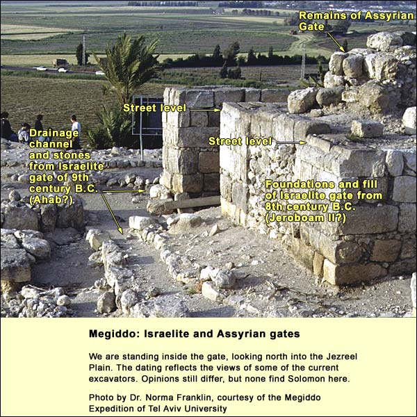
This verse has led many to seek evidence of Solomon at Megiddo. The American expedition discovered a massive gate with 8 piers of dressed stones, forming 6 chambers facing each other. Similar gates were found at Hazor and Gezer. The latter two are connected to casemateA double wall with short cross-walls dividing it into chambers. walls. When the dean of Israel's archaeologists, Yigal Yadin, found remains of what he thought was a casemate wall at Megiddo not far from the gate, he saw here a confirmation of the Biblical verse. He identified the gate and supposed wall as Solomonic.
The new expedition, however, has found no continuation for Yadin's "casemate wall." The remains he identified as such belonged to a building. What is more, the American expedition of the 1920's and 30's did find a wall attached to the gate, but it was solid, not casemate, and it is universally thought to be later than Solomon's time: 9th or 8th century BC. According to members of the present expedition, most of the gate we see today was the foundation. But why use dressed stones for a foundation?
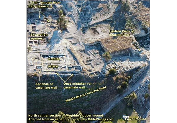
The palace whose outlines appear in the picture above is dated by the current excavators to the 9th century BC. Throughout the Israelite period Megiddo was an administrative center and army base, not a city for many people. As in the Late Bronze Age, the center of the mound was not inhabited. We find palaces and stables (or storerooms), a public grain silo, and a large empty area that may have served as a yard for exercising horses. In time of need, however, people from the surrounding villages could have taken refuge in the city. The ruler would not have wanted the peasants to remain outside, where they could farm the land for a besieging army.
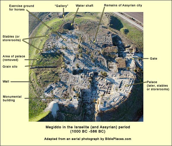
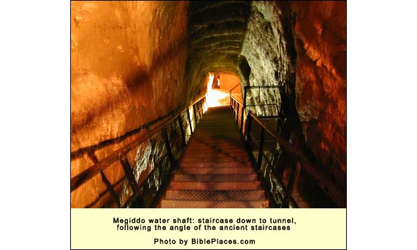
The most remarkable feature of Israelite Megiddo was the internal water system, created to secure the supply in time of siege. (It is possible that it predated the Israelites). To it we devote a separate article.
In 735 BC, the Assyrians conquered Megiddo and established a city here, the first in more than 250 years to fill the entire upper mound. They exiled and dispersed the members of the kingdom of Israel (or at least their leaders), who lost their national identity. (2 Kings 17:5-6.Then the king of Assyria came up throughout all the land, and went up to Samaria, and besieged it three years. In the ninth year of Hoshea the king of Assyria took Samaria, and carried Israel away to Assyria, and placed them in Halah, and on the Habor, the river of Gozan, and in the cities of the Medes.)
And so we come around to the account of King Josiah's death at Megiddo, discussed earlier, which formed the background to the prophecy of Armageddon.
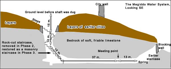
Now the workers needed to hew a horizontal tunnel, but the question was, in which direction? They planted someone on the slope above the spring, and then they stretched a rope from that person across the top of the shaft they had already dug. Two plumblines hanging from this rope - more exactly, a straight line joining the plumblines - would function like an arrow showing them the direction toward the spring. They must have had workers posted on the staircase looking up at the plumblines and directing the hewers below.
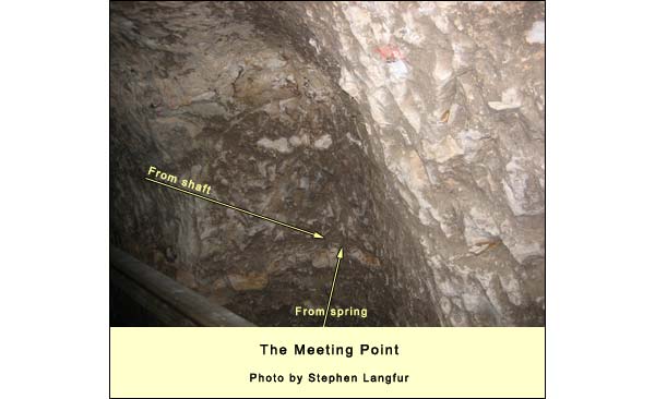
Another team worked from the spring. They had no help from plumblines here. When we stand at the spring and look back through the tunnel, we can see that they went too far to the left. After they had hewn for about 8 meters, however, they must have heard the chisels of the team from the shaft-end (still about 15 meters away) and they made a correction to the right.
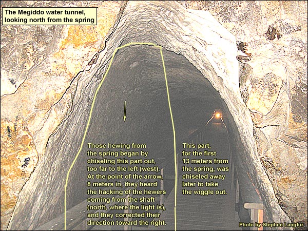
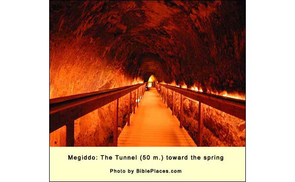
Below is the point of meeting on the right (east). Those from the shaft-end must have started earlier, for they cut through 37 meters. Those from the spring-end cut through 13. They widened the tunnel on the spring-end in order to get rid of the wiggle. Then the whole tunnel was deepened to allow easy passage. The old entrance from outside the mound was blocked with a wall.
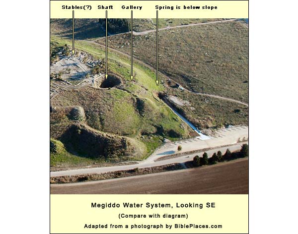
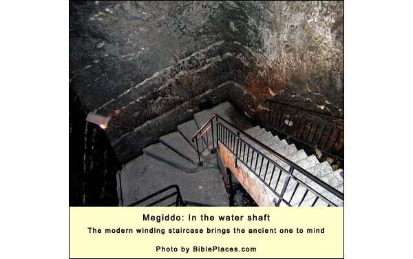
In a second phase, workers removed the rock-cut staircase and angled the floor of the tunnel so that the water would flow to a point directly beneath the shaft, whence it could be hauled as from a well. At the third and last phase, however, a masonry staircase was built roughly where the original had been. This kind of water system was common to many of the larger cities. We find variations of it at Hazor, Ibleam, Gezer, Gibeon, Beersheba and elsewhere. Jerusalem's system goes back to the 18th century BC. Indeed, one site, called Khirbet ez-Zeraqun, has a rock-cut water system dating to the third millennium BC. But the Megiddo shaft is one of the few that today are easily accessible, and it is astonishing to see what the ancients could do. Which ancients? There is currently no way of knowing when the system was first created. It may have been in use when the city's inhabitants held out for seven months while besieged by Pharaoh Thutmosis III. A sign at the shaft, now wisely removed, once informed us that it was hewn in the 9th century BC when Ahab was king. This dating was based on Yadin's conclusions concerning an artificial passage called the Gallery, a section of which was found on the upper edge of the tell. This Gallery seems to have been a covered passage, 2 meters high, leading down the slope toward the spring. Yadin dated it to Solomon's time. Over it ran a solid wall. The theory went like this: before the shaft was dug, water drawers used the Gallery in time of siege to reach the spring without being seen. After the shaft was dug, there was no longer a need for it. Since the Gallery was thought to have been used in Solomon's time, the shaft and wall were attributed to the next great builder-king in the north, Ahab. In attributing the Gallery to Solomon, Yadin depended on one of its dressed stones, which he identified as Solomonic. But Megiddo excavator Norma Franklin,Norma Franklin, "Relative and Absolute Chronology of Gallery 629 and the Megiddo Water System: A Reassessment" in Israel Finkelstein, David Ussishkin and Baruch Halpern, eds., Megiddo III: The 1992-1996 Seasons, Tel Aviv, 2000 (p. 517) has pointed out that the stone in question may have been recycled, as were similar ashlars in the wall above. She notes, also, that the Gallery was built more strongly precisely at the points where it had to bear the weight of the wall above. Conclusion: Gallery and wall were built as a single unit. The Gallery served as a postern, that is, a rear gate through which the city's defenders could make sorties against a besieging enemy, especially if the latter were trying to penetrate to the covered spring. On this reasoning, the shaft may have preceded the Gallery! In other words, if the Gallery was intended as a postern, it could have been added later, so we cannot date the original shaft on the basis of it. There is, as Franklin says, no chronological anchor. To visit the water shaft requires a descent of 183 modern steps. After passing through the tunnel, one reaches the spring. It hardly resembles a spring today, because the {jtips}A layer of water-bearing bedrock{/jtips}aquifer is drained by current users before its water reaches the spot. During a hefty rain, however, the water again gurgles forth in proper springlike fashion. Climbing up and out, using the pre-shaft access - an ascent of 80 steps or so - we emerge outside the mound. From here we can look back and see the Gallery above us. Our bus may be waiting nearby. If not, we turn right just before the fence (we don't go through the turnstile) and follow the signs to the entrance. {mospagebreak title=Logistics} Logistics Phone: (04) 659-0316. Nature Reserves and National Parks (Main office: 02/500-5444) Opening hours (figure on taking at least 2 hours at the site): April 1 through September 30 (approximate dates), from 8.00 - 17.00. (Entrance until 16.00)* October 1 through March 31 (approximate dates), from 8.00 - 16.00. (Entrance until 15.00)* *On Fridays and the eves of Jewish holidays, the site closes one hour earlier. For example, on a Friday in March one must enter no later than 14.00 and leave by 15.00 (which is not enough time - one needs 2 hours at least). Note: the water shaft, a major highlight, closes half an hour before the site does. It involves a descent (illuminated, with banister) of 183 steps and an ascent of about 80 to a street west of the site, where the bus can meet you, or from which you can follow signs back to the entrance.
Restrooms at the entrance only. There is no shade on the mound, but often a strong wind in the afternoon. Bring a hat, water, good walking shoes, a Bible and a map.