Dan (Tel Dan)
The second major road also came from Damascus, stretched westward from the city and reached the sea at Tyre or Sidon. This may have been the "way of the sea" (Vulgate: via maris"Via Maris" was not a Roman term denoting a road somewhere. It is the Latin translation of Isaiah 9:1 (in the Hebrew Bible, 8:23) – "the way of the sea." The prophet was probably referring to the road from Dan to the sea at Tyre, which marked the northern border of Israel at the time of the Assyrian conquest. See Anson Rainey, "Toponomic Problems (cont.)" in Tel Aviv 8 (1981)) of Isaiah 9:1, quoted in Matthew 4:15-16.“The land of Zebulun and the land of Naphtali, toward the sea, beyond the Jordan, Galilee of the Gentiles, the people who sat in darkness saw a great light, to those who sat in the region and shadow of death, to them light has dawned.” The connection with Sidon is obliquely attested in Judges 18:7, "They (the people of Laish, which was the name before Dan) "were far from the Sidonians, and had no dealings with any man.
cb(18,8); "
A third major road passed nearby: it stretched north from Hazor to the cities of the Tigris, via Carchemish and Haran.
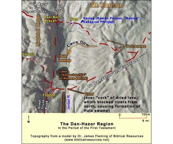
Having command of such a junction, Dan would not have allowed a rival to develop at the nearby spring of Banias. If you didn't pay your toll and spend your money, you would soon find out that (Genesis 49:17):
The story of the Danite conquest (Judges 18) is best told atop the southwestern part of the tell at the Pistachio Tree Lookout. From here, facing south, we can see part of Mt. Hermon and the Golan Heights to the east; the Naftali ridge to the west; the Hula Valley south of us; and on its horizon, the basalt barrier mentioned at Hazor. The barrier has a V-like cut made by modern Israel when it drained the Hula swamp in the 1950's. {mospagebreak title=Gate of Judgment} The Gate of Judgment Heading east from the pistachio tree, crossing an old trench of the Israeli army (for Dan is on the border with Lebanon and the army had positions here until 1967) we take the steps down the rampart and continue east, arriving at a large gate system, partly reconstructed. The gate we see from the trail is the outer of two (not counting the traces of an unreconstructed gate that is nearer to us on the east or right). Biran at first attributed them to Ahab, but the results of his further excavations suggest a somewhat later date. These further excavations were undertaken after a spectacular find: In the late afternoon of July 1993 (so the story goes), the dig's recorder was making a note a few yards to the east of these two gates, in the cobbled plaza, when she tripped and fell. On rising, her eye caught something lit by the slanting rays of the sun: an inscription! There were in fact quite a number of words engraved on the smooth side of a rock that belonged to the ruin of a wall. This rock had been recycled in the building of the wall: it was the large fragment of a stele that someone had deliberately smashed. The language was Old Aramaic, and among the words could be made out "Israel" and "house-of-David," written as a single construct. This is so far the only extra-biblical reference to David dating from within 150 years of his death (or, if Lemaire's reconstruction of the Mesha stele is right, it is one of two). Against minimalist views of the accounts in Samuel and Kings, it shows not only that David existed but that he was important enough to have established a "house," whether this word refers to a dynasty or a place (Jerusalem).
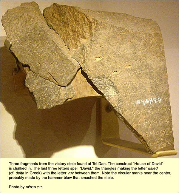
The interpretation of the inscription is a matter of hot dispute, which will not be settled until more fragments are found. (In fact two small fragments have been found and are picture above to the left of the main one, but they do not settle anything.) SomeA. Biran and J. Naveh, The Tel Dan Inscription: A New Fragment, Israel Exploration Journal, Vol. 45, No. 1 (1995), pp. 1-18. think that the inscription's author was the Aramean Hazael, who usurped the power in Damascus around 743 BC and conquered large swathes of territory; he seems to be claiming credit for killing the "king of Israel" and a king from the House-of-David. If these were, respectively, Joram son of Ahab and Ahaziah of Judah, that would contradict the Biblical account of Jehu's killing them (2 Kings 9:14-29). Others argue that the author was Hazael's son, Ben Hadad II, who was threatened on his northern front by Assyria and erected the stele to cow his subjects. (See also a book by Athas.) The smasher could have been someone loyal to King Joash of Israel, or his son Jehoshaphat II, in the early 8th century, when one or the other restored Dan to Israel. It is tantalizing to stand here and look at the ruins, knowing that they must contain the pieces that would solve the puzzle. The fragments are on display at the Israel Museum in Jerusalem. The whole gate system was covered in the ash of the destruction by Tiglath Pileser III, King of Assyria, around 735 BC. As we enter the first reconstructed gate, we see a small platform, original and in situ, with carved stone bases (one of them original) at its corners. These held wooden posts which supported a canopy. To the right is a long bench. Often in the Bible we read of a court session taking place in the city gate or of the elders sitting there. This makes sense, because most people were not living in the city at all, rather in villages outside. Often there would be disputes involving the rural folk, and the ideal place would be the gate. Here at Dan, uniquely, the courtroom has been found: both the platform which supported the ruler's throne and the bench for the elders. The whole procedure was sanctified by a standing stone (Heb. matzeva) to the left of the platform: the ruler's right. After facing the Chief Justice, if we now turn to the right, we see a modest construction including five standing stones (below).
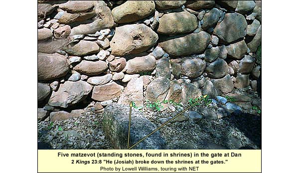
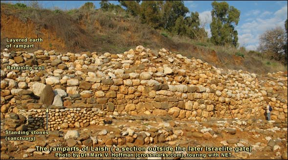
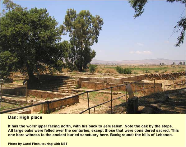
When the ancients located a place as sacred, they often set up such stones. The gate included a sanctuary. The low benches must have held offerings. There was a time, apparently, when many towns in Israel and Judah had shrines in their gates, for King Josiah, we learn, destroyed them: "He broke down the high places of the gates." (2 Kings 23:8) This shrine at Dan escaped Josiah: it had lain under ash for a century by the time his reign began (and besides, his reforming hand did not reach this far north). There was a logic in having shrines at the gates. People wanted divine protection at their borders, whether of the city or the nation. Concerning the nation, the first king of the north, Jeroboam son of Nebat, set up shrines with golden calves at the two extremities of his domain: Bethel and Dan. The high place at Bethel has not been found, but Biran has excavated the one at Dan. We head in its direction, but several things will interrupt us on the way. We go through the gates with their chambers, noting the stones in which the hinges swiveled and, on the inside of the inner gate, the mark of the slamming door. As we ascend the path, our right side would be exposed to the Israelite wall above (if the Assyrians hadn't dismantled it in 735 BC). Since most people are right-handed, members of an attacking army would have had their spears in their right hands and their shields in the left. The access is set up, then, to catch right-handed attackers here. An enemy army would send its left-handed soldiers first, but there is another bend above to deal with them. This double-L access is standard through the ages (e.g., the main Crusader gate at Caesarea Maritima, the Damascus Gate in Jerusalem). At the top of the zigzag path are the remains of yet another gate, later than those below. It was built as an extra defense against the Assyrians (Biran,Avraham Biran, Biblical Dan, Jerusalem: Israel Exploration Society, 1994 p. 246). {mospagebreak title=Early Danites} Traces of the early Danites Following the modern tourist path, we spot a big excavation on the right. If we walk to its north side and look down in, we can see, above the Canaanite levels and intruding into them, a pit lined with small stones. This is one of many such pits that were here. The diggers cleared most of them in order to explore the levels underneath. Such pits are significant. First, they do not fit the kind of upper-class urban culture that characterized Canaanite Laish (as the city was called before the Danites took it). They are thought to be grain-storage pits, made and used by families with little economic surplus. We find clusters of such pits in the numerous small settlements that sprang up throughout the land in the late 13th and the 12th centuries BC. Many of these developed or consolidated into what came to be known as Israelite towns. Here, then, we have a trace of the conquering Danites, who settled in rougher style amid the ruins of what had been an affluent urban culture. The excavators also found fragments of many large storage jars having necks like a collar, and they were able to date them to the 12th century BC. Such jars are not at all typical of Galilee, but they are extremely typical of the above-mentioned proto-Israelite settlements in the hill country farther south. This would fit the notion that the diggers of the storage pits migrated from the south, i.e., that they were the Danites of Judges 18. Returning to the cobbled tourist path, we continue north, soon arriving at the Israelite sanctuary. {mospagebreak title=Golden calf} The Place of the Golden Calf In 1 Kings 12 we read how after Solomon's death, the kingdom split into two parts, Israel in the north and Judah in the south. Before us we have the most tangible sign of that schism: the sanctuary built by Jeroboam the son of Nebat (and added to by his successors) as a rival to the Temple in Jerusalem. The new king of the north set up golden calves and built high placesIn ancient Israel people used to worship on high places (bamot). This was quite in order until the Book of Deuteronomy (12:4) restricted the cult to one center alone. Samuel himself officiated at one high place (1 Samuel 9:12 - 14). The top of an early Israelite example may be viewed at Hazor beneath the (later) foundations of Ahab's palace there. The grandest is the platform at Dan. on the borders of his realm at Dan and Bethel. At Dan the excavators found the high place. Biran and his colleagues noticed an area on the tell that seemed especially suitable. There is a good freshwater spring and an open view to the north, with Mt. Hermon on the right and the Naftali Ridge on the left. Jeroboam, rejecting Jerusalem, would likely want to face away from it: to the north. On the site today one sees an odd aluminum construction, representing the sacrificial altar, as well as a monumental staircase leading up to the high place. Here we can easily distinguish between original stonework and reconstruction. The dressed stones in its wall to the right of the stairs are set in header-stretcher pattern, a technique common to Phoenician and Israelite royal builders. Pottery fragments led Biran to identify the funder as Ahab. It is unclear whether the high place continued in use during the last half of the 9th century BC, when Hazael of Aram had sway in Dan, but much of what we see today is attributed to Jeroboam II (first half of the 8th century BC). It is square, almost 60 feet long on each side, and rose 9 feet above its surrounding courtyard. Probes exposed, beneath it, parts of the original high place built by Jeroboam I, son of Nebat (apparently the first on the spot). A section of this can now be seen immediately east of the staircase. This was the floor of the first platform here.
The monumental staircase was an addition of Jeroboam II, although traces of an older one also turned up. The diggers also found a stone horn of his altar (about 19 inches high and 15 inches long at the base, which is on display in the Skirball Museum of the Hebrew Union College in Jerusalem). The reconstructors used it to estimate the size of the altar itself, represented by the present metal contraption. The kings before him also had altars here. We note the steps that would have led to the top (a violation of Exodus 20:26"Neither shall you go up by steps to my altar, that your nakedness may not be exposed to it." ). Surrounding the altar is a wall. The chambers west of this wall yielded smaller finds, including a numbered die whose opposite sides always add up to seven. It may have been used in getting oracles. After the Assyrian conquest, the sanctuary probably went out of use, but in the Greek period, four centuries later, it flourished again, and from here we have that happiest of finds, an inscription naming the place. It occurs on stone, in Greek and Aramaic: "To the god who is in Dan." Discovered in 1976, a decade after the dig began, this was the first positive indication that the site really was Dan. Until then that had been surmise, based partly on the Arabic name for the tell: Tell al-Kadi, the hill of the judge: dan, in Hebrew, is the root for "judge." Before us, then, is "the sin of Jeroboam", mentioned over and over in the Books of Kings, as in 1 Kings 16:26, For he walked in all the way of Jeroboam the son of Nebat, and in his sins with which he made Israel to sin, to provoke Yahweh, the God of Israel, to anger with their vanities. Standing near the spring (located south of the altar, a few yards into the trees near the southern side of the tourist path), we can re-read Psalms 42 and 43. If we put ourselves in the position of one who longed to make the forbidden pilgrimage to the Temple in Jerusalem, as in the days before the schism, these songs take on new resonance. {mospagebreak title=Arched gate} A triple-arched gate 3750 years old We ascend to the eucalyptus trees just east of the aluminum altar. After a glance into Lebanon, we head a few steps north and find a path that leads east for 200 yards, then south for another 150, until we encounter a sign pointing us to the left down the slope. After descending, we see on our right, set back into the rampart, what looks at first like a doorway. The archaeologists have dug out only part of an arched entrance. It is made of mud bricks laid in radial pattern. There are two similar arches beyond it inside. The whole thing is set in a mud-brick wall. Using bits of pottery discovered in the plaster that covered this wall, together with a few vessels found on the floor inside, Biran dated this gate to the 18th century BC. So much for the myth that the Romans discovered the arch!
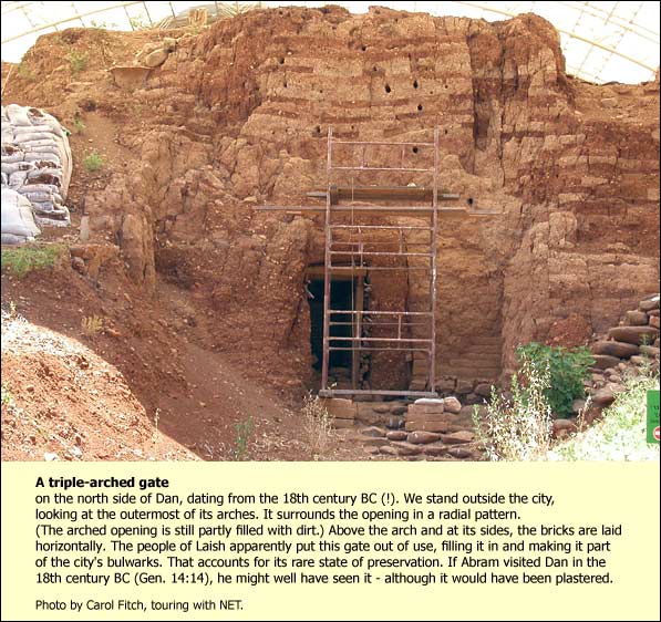
Biran was also able to determine that the Laishites deliberately put the gate out of commission, filling it in and incorporating it as part of the rampart. Apparently, they considered the straight entrance insecure. The happy result, for us, was that the earth preserved the entire assembly. Except for the recently discovered Canaanite gate at Ashkelon, everywhere else we only see foundations or pieces of gates and walls, and we have to extrapolate in order to reconstruct them in our imaginations. Here we have the full thing, except for the plaster coating, even as a visitor like Father Abram might have seen it on reaching "Dan" (Genesis 14: 14). In order to leave the site, we stay below and continue a few steps south, then west around the base of the tell. Soon Ahab's gate complex comes into view. We continue west, remaining below and passing it, for about 150 yards more, until a sign points us left to the wading pool. From here it is a short walk to the parking lot, the restaurant -- and restrooms! {mospagebreak title=Logistics} Logistics Nature Reserves and National Parks (Main office: 02/500-5444) Opening hours: April 1 through October 31, from 8.00 - 17.00. (Entrance until 16.00)* November 1 through March 31, from 8.00 - 16.00. (Entrance until 15.00)* *On Fridays and the eves of Jewish holidays, the sites close one hour earlier. For example, on a Friday in March one must enter by 14.00 and leave by 15.00. Telephone at Dan: 04/695-1579 The visit takes between two and three hours. There are restrooms and a restaurant in the parking lot. Wear good walking shoes and have both hands free.